
Melbourne sprawls. Across roughly 9,900 square kilometres and more than five million people, the city fans out from a tight laneway core into bayside enclaves, creative inner-north strips, leafy eastern foothills, growth-corridor estates, and a semi-rural peninsula. To make sense of it, the Victorian Government’s Plan Melbourne 2017–2050 carves the metropolitan area into six planning regions: Inner Metro, Inner South East, Western, Northern, Eastern, and Southern. Think of them as Melbourne’s six personalities, each with its own postcode logic and weekend routine.
For anyone relocating, house-hunting, or choosing a weekend base, the six-region framework is the fastest way to grasp how Melbourne hangs together. Each region bundles several local government areas (LGAs) that share geography, transport spines, and a broadly similar lifestyle, even if the suburbs inside them quietly disagree on everything else. Skim the quick table to place an LGA, then scroll to the region you’re curious about. Distances are measured from the Melbourne CBD, because that’s still how the city measures itself.
LGA Quick-Reference Table
| Region | Local Government Areas | Distance from CBD |
|---|---|---|
| Inner Metro | City of Melbourne, City of Port Phillip, City of Yarra | 0–6 km |
| Inner South East | City of Stonnington, City of Boroondara, City of Glen Eira, City of Bayside | 4–15 km |
| Western | City of Maribyrnong, City of Moonee Valley, City of Hobsons Bay, City of Brimbank, City of Wyndham, City of Melton | 4–40 km |
| Northern | City of Merri-bek, City of Darebin, City of Banyule, Nillumbik Shire, City of Whittlesea, City of Hume, Mitchell Shire (southern portion) | 5–50 km |
| Eastern | City of Manningham, City of Whitehorse, City of Monash, City of Maroondah, City of Knox, Yarra Ranges Shire | 15–80 km |
| Southern | City of Kingston, City of Greater Dandenong, City of Frankston, City of Casey, Cardinia Shire, Mornington Peninsula Shire | 15–100 km |
Melbourne Regions Map
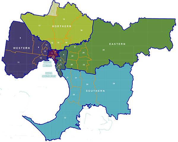
Local Government Area boundary
Metropolitan Partnership boundaries
Part of Mitchell Shire (1)
Region
- 1. Melbourne
- 2. Port Phillip
- 3. Yarra
East Region
- 4. Stonnington
- 5. Bayside
- 6. Boroondara
- 7. Glen Eira
Region
- 8. Melton
- 9. Brimbank
- 10. Hobsons Bay
- 11. Wyndham
- 12. Moonee Valley
- 13. Maribyrnong
Region
- 14. Banyule
- 15. Whittlesea
- 16. Nillumbik
- 17. Hume
- 18. Moreland
- 19. Darebin
- 20. Mitchell (part)
Region
- 21. Manningham
- 22. Whitehorse
- 23. Knox
- 24. Yarra Ranges
- 25. Maroondah
- 26. Monash
Region
- 27. Kingston
- 28. Frankston
- 29. Cardinia
- 30. Casey
- 31. Greater Dandenong
- 32. Mornington Peninsula
Inner Metro Region: the dense, caffeinated core
The Inner Metro Region is Melbourne at full volume. It’s the smallest region by area and the loudest by everything else: laneway coffee queues, tram bells, street art, rooftop bars, and the permanent hum of a city that treats culture like a public utility. Three LGAs make up the core: the City of Melbourne, the City of Yarra, and the City of Port Phillip, covering the ground from Flemington down to the bay at St Kilda.
Geographically, it’s tight. Nothing sits more than about 6 km from Flinders Street, which is why locals cheerfully walk distances that would feel absurd in any other Australian capital. Each LGA has its own accent. The City of Melbourne delivers the CBD, Docklands, and student-heavy Carlton. The City of Yarra bundles bohemian Fitzroy with multicultural Richmond and the industrial-cool of Collingwood and Abbotsford. The City of Port Phillip holds the bayside trifecta of St Kilda, Albert Park, and Port Melbourne, where the tram ends at the sand.
Key suburbs read like a greatest-hits list: the CBD, Southbank, Docklands, Carlton, Fitzroy, Collingwood, Abbotsford, Richmond, St Kilda, South Yarra, Windsor, Port Melbourne, Albert Park, and South Melbourne. For things to do, take your pick: wander laneway street art, eat at Queen Victoria Market before 10am, catch a Test at the MCG, or settle in at St Kilda for a sunset swim and pizza. The NGV, Arts Centre, and Hamer Hall anchor a world-class arts precinct; Melbourne Park hosts the Australian Open and Albert Park the F1 Grand Prix (the noise is genuinely unreal).
Transport: getting around is almost comically easy. The Free Tram Zone covers the CBD, every major rail line passes through Flinders Street, Melbourne Central, and Southern Cross, and the 250-plus kilometre tram network fans out from this core. This region suits travellers, young professionals, students, culture-seekers, foodies, and anyone on a short stay.
Inner South East Region: established, leafy, and quietly loaded
If the Inner Metro is Melbourne in a leather jacket, the Inner South East is Melbourne in a well-cut trench coat. This is the city’s prosperous established belt, sweeping south and east to take in four LGAs: Stonnington, Boroondara, Glen Eira, and Bayside. It runs from Hawthorn and Kew in the north through Malvern and Caulfield in the middle, down to the bathing-box coastline at Brighton and Sandringham.
The character is old money in new paint. Grand Edwardian and Federation homes sit behind mature plane trees, private schools dominate whole postcodes, and the shopping strips (Chapel Street, Glenferrie Road, Church Street in Brighton) carry a no-rush confidence. Boroondara is routinely Melbourne’s most prestigious established municipality. Stonnington pairs upmarket fashion with the late-night edge of Chapel Street. Bayside trades in coastal lifestyle, including the colourful bathing boxes at Brighton Beach. Glen Eira is quieter, with one of the world’s largest Jewish communities around Caulfield and Elsternwick.
Key suburbs include: Toorak, South Yarra, Prahran, Windsor, Malvern, Hawthorn, Camberwell, Kew, Brighton, Hampton, Sandringham, Caulfield, Bentleigh, and Elsternwick. Head to Chapel Street for shopping and people-watching, Como House for Victorian-era gardens, the Camberwell Sunday Market for vintage (arrive early, parking is combat), and the bathing boxes for the obligatory photo.
Transport: is well served but tram-light the further east you go. The Sandringham line runs to Brighton; the Frankston and Glen Waverley lines serve Caulfield and Bentleigh; the Alamein, Belgrave, and Lilydale lines loop through Camberwell and Hawthorn. Trams cover Chapel Street, Toorak Road, and Malvern Road. This region suits families chasing prestigious schools, affluent buyers, bayside lifestyle seekers, and empty-nesters who want a tram into town without the CBD price tag.
Western Region: multicultural, rising fast, and long underestimated
The Western Region is Melbourne’s sleeper hit. Once dismissed as flat and industrial, the west has quietly become one of the most interesting parts of the city to eat, live, and watch evolve. Six LGAs: Maribyrnong and Moonee Valley on the inner fringe, Hobsons Bay on the coast, and Brimbank, Wyndham, and Melton stretching into the growth corridors. Footscray sits just 4 km from the CBD; Melton is a full 40 km west.
Character shifts dramatically as you move outward. Inner-west Footscray and Yarraville have gentrified without losing their Vietnamese, Ethiopian, and Horn of Africa food cultures. Williamstown, on a peninsula jutting into the bay, feels like a maritime heritage village complete with tall ships and fish and chips by the water. Sunshine and St Albans are multicultural in a way few Melbourne postcodes match. Further out, Point Cook, Tarneit, Werribee, and Caroline Springs are building new suburbs at a pace that changes the map every quarter.
Key suburbs worth knowing: Footscray, Yarraville, Seddon, Williamstown, Altona, Newport, Sunshine, St Albans, Moonee Ponds, Essendon, Flemington, Werribee, Point Cook, Tarneit, and Melton. For things to do, take the kids to Werribee Open Range Zoo for a safari bus through giraffe country, tour Werribee Mansion and the State Rose Garden, catch a film at the art-deco Sun Theatre in Yarraville, and graze your way through Footscray Market (go hungry, bring cash).
Transport: runs on the Werribee, Williamstown, Laverton, Sunbury, and Craigieburn rail lines, with Footscray as a major interchange. A summer ferry links Williamstown to Southbank (it’s the best commute you’ll ever have). Outer Wyndham and Melton are largely car-dependent. This region suits first-home buyers, multicultural communities, maritime-history enthusiasts, new migrants, and investors watching Melbourne’s fastest-growing property market.
Northern Region: creative inner-north meets galloping growth corridor
The Northern Region is two regions wearing a trench coat. Inner-north Brunswick, Coburg, Northcote, and Preston are Melbourne’s creative spine (live music, vegan bakeries, tattoo studios, unreasonably good coffee). Outer-north Craigieburn, Epping, and Sunbury are some of the country’s fastest-growing residential corridors. The region stretches from 5 km out to around 50 km and takes in seven LGAs: Merri-bek, Darebin, Banyule, Nillumbik Shire, Whittlesea, Hume, and the southern portion of Mitchell Shire (included for planning purposes because its southern tip sits inside the Urban Growth Boundary).
Character here is bohemian meets suburban-new-build, with a leafy semi-rural buffer between. Merri-bek (renamed from Moreland in November 2022) and Darebin are synonymous with Melbourne’s progressive, creative identity: independent music venues, art-deco cinemas converted into bars, and a High Street in Northcote that Time Out named one of the world’s coolest streets in 2024. Banyule and Nillumbik go green and arty (Eltham has been an artists’ enclave for nearly a century). Hume and Whittlesea do volume: new schools, new freeways, new neighbourhoods every year.
Key suburbs include: Brunswick, Coburg, Northcote, Preston, Thornbury, Heidelberg, Ivanhoe, Greensborough, Bundoora, Eltham, Epping, South Morang, Craigieburn, Broadmeadows, and Sunbury. Wander Sydney Road Brunswick (Melbourne’s longest continuous shopping strip), spend an afternoon at CERES, eat your way along High Street Northcote, and head to Eltham for the Nillumbik galleries.
Transport: is solid inward and patchier outward. The Craigieburn line serves Brunswick, Coburg, and Broadmeadows; the Mernda line covers Darebin and Whittlesea; the Hurstbridge line runs through Banyule to Eltham. Tram route 19 is the Sydney Road workhorse. This region suits creatives and musicians, young professionals, multicultural families, first-home buyers chasing the outer corridors, and anyone who wants a La Trobe postcode in Bundoora.
Eastern Region: leafy liveability, hills, and the Yarra Valley
The Eastern Region is where Melbourne goes to settle down and grow up. It’s consistently ranked among the most liveable slices of the city, thanks to established family-friendly suburbs, quality public schools, walkable village centres, and a ribbon of parks that leads, eventually, to the Dandenong Ranges and the Yarra Valley wine country. Six LGAs cover the arc: Manningham, Whitehorse, Monash, Maroondah, Knox, and Yarra Ranges Shire. It runs from Box Hill and Doncaster at 15 to 20 km out to Healesville and Warburton at 80 km.
Character is leafy, layered, and quietly cosmopolitan. Box Hill in Whitehorse is sometimes called Melbourne’s New Shanghai for good reason: Asian supermarkets, yum cha tables that turn over by the minute, Korean BBQ, and Vietnamese pho all stacked in one walkable grid. Glen Waverley in Monash is a second major Asian community hub. The standout LGA is Yarra Ranges Shire: the Dandenong Ranges National Park, Puffing Billy steaming through mountain ash forests, Healesville Sanctuary, and more than enough cellar doors to fill a long weekend.
Key suburbs include Doncaster, Templestowe, Box Hill, Blackburn, Glen Waverley, Clayton, Ringwood, Croydon, Wantirna, Boronia, Lilydale, Healesville, Yarra Glen, Olinda, and Belgrave. Take the kids to Healesville Sanctuary for Australian native wildlife, ride Puffing Billy through the ferns (legs dangling, of course), and plan a Yarra Valley wine day around Domaine Chandon, Oakridge, and Four Pillars Gin in Healesville.
Transport leans on the Belgrave and Lilydale lines (via Ringwood, Boronia, and Lilydale) plus the Glen Waverley line. The Eastern Freeway (M3) and the Monash Freeway (M1) do the driving, with EastLink (tolled) linking them. Outer Yarra Ranges is firmly car country. This region suits families after quality schools and parkland, food and wine enthusiasts chasing the Yarra Valley, nature-lovers and hikers, weekend day-trippers, and students at Monash University Clayton.
Southern Region: bayside, diverse, and home to the peninsula
The Southern Region is Melbourne at its most varied. No other region swings through such a range of environments in one run, from bayside family suburbs to one of the country’s most culturally diverse municipalities, to the famously good Mornington Peninsula at the southern tip. Six LGAs: Kingston, Greater Dandenong, Frankston, Casey, Cardinia Shire, and Mornington Peninsula Shire. It stretches from Moorabbin at 15 km south of the CBD all the way to Portsea at more than 100 km.
Character shifts with every 10 km of freeway. Kingston offers affordable bayside living along the Chelsea and Mordialloc foreshore. Frankston is the region’s growing arts and services hub and the gateway to the peninsula. Greater Dandenong is Melbourne’s most culturally diverse LGA, with large Afghan, Cambodian, Vietnamese, Sri Lankan, Indian, and Pacific Islander communities around Dandenong and Springvale (the food is extraordinary). Casey and Cardinia are booming outer family corridors. The Mornington Peninsula is the showstopper: more than 50 cellar doors, hot springs, surf beaches, back beaches, farm gates, and weekenders in equal measure.
Key suburbs include Moorabbin, Cheltenham, Chelsea, Mentone, Frankston, Dandenong, Springvale, Noble Park, Berwick, Narre Warren, Cranbourne, Pakenham, Mornington, Rosebud, Sorrento, Portsea, Red Hill, and Flinders. Plan a day around Peninsula Hot Springs in Rye, ride the Arthurs Seat Eagle gondola, walk the clifftops at Point Nepean, and eat your way through Springvale for lunch (Afghan bread, Cambodian noodle soup, Sri Lankan kottu, all within a kilometre).
Transport covers the Frankston line to Chelsea, Mentone, Mordialloc, and Frankston, plus the Pakenham and Cranbourne lines through Dandenong. Beyond Frankston a car is close to essential. In summer, the Sorrento–Queenscliff ferry is a scenic shortcut across the bay heads. This region suits families in newer estates in Casey and Cardinia, beach-lifestyle seekers, peninsula wine and food enthusiasts, multicultural communities in Greater Dandenong, retirees and sea-changers, and day-trippers chasing hot springs.
Frequently Asked Questions
How many regions does Melbourne have?
Metropolitan Melbourne is divided into six planning regions under the Victorian Government’s Plan Melbourne 2017–2050 framework: Inner Metro, Inner South East, Western, Northern, Eastern, and Southern. Together they cover 31 metropolitan local government areas, plus the southern portion of Mitchell Shire.
What is the difference between Melbourne’s eastern and western suburbs?
Melbourne’s eastern suburbs are generally more established, leafy, and well-serviced by public transport, with a reputation for good schools and family amenity. The western suburbs are more multicultural and diverse, historically working-class, and now rapidly gentrifying in the inner west (Footscray, Yarraville) with major greenfield growth in the outer west (Wyndham, Melton). The west tends to offer better affordability; the east is associated with prestige schools, the Dandenong Ranges, and the Yarra Valley.
What are the inner suburbs of Melbourne?
Melbourne’s inner suburbs are typically those within about 10 km of the CBD. The Inner Metro Region covers the CBD plus Yarra (Fitzroy, Richmond, Collingwood) and Port Phillip (St Kilda, South Melbourne, Port Melbourne). Nearby Inner South East suburbs include South Yarra, Prahran, Hawthorn, and Malvern. The inner-north (Brunswick, Northcote, Coburg) sits within the Northern Region.
Where is the Mornington Peninsula in relation to Melbourne?
The Mornington Peninsula is part of Melbourne’s Southern Region, extending roughly 70 to 100 km south of the CBD. It forms the western arm of the bay, with Port Phillip Bay on its western side and Western Port Bay to the east. Major townships include Mornington, Rosebud, Rye, Sorrento, and Portsea at the tip. It’s accessible by car via the Mornington Peninsula Freeway, or by train to Frankston followed by bus.
Is the Yarra Valley in Melbourne?
The Yarra Valley and Dandenong Ranges fall within the Eastern Region of metropolitan Melbourne, specifically Yarra Ranges Shire and (at its inner fringe) the City of Manningham. While it feels like a rural escape, it’s within the metropolitan planning boundary. Key destinations like Healesville, Lilydale, and Yarra Glen are 45 to 75 minutes by road from the CBD.
What is the Northern Region of Melbourne like?
Melbourne’s Northern Region spans from the inner-north suburbs of Brunswick, Coburg, and Northcote (just 5 to 8 km from the CBD) out to the fast-growing outer corridors of Craigieburn, Epping, and Sunbury. The inner LGAs of Merri-bek and Darebin are known for their creative arts scene, independent music venues, multicultural dining, and progressive community culture. The outer LGAs of Hume and Whittlesea are among Melbourne’s fastest-growing residential areas.
Which part of Melbourne is best for families?
Family-friendly areas vary by budget and priorities. The Eastern Region (Manningham, Whitehorse, Maroondah, Knox) is consistently popular for its quality schools, leafy streets, and parks. The Inner South East (Boroondara, Bayside, Stonnington) is prestigious but expensive. The Northern Region’s middle ring (Banyule, Darebin) and the Southern Region’s growth corridors (Casey, Cardinia) offer more affordable options for families. The Mornington Peninsula suits families who prefer a sea-change lifestyle.
What does LGA mean in Melbourne?
LGA stands for Local Government Area, which is the municipality governed by a local council. Metropolitan Melbourne has 31 LGAs, each with its own council responsible for planning, roads, parks, and community services. For planning purposes, the Victorian Government groups these LGAs into six regions. Every suburb belongs to one LGA.
Why is Mitchell Shire included in Melbourne’s Northern Region?
Mitchell Shire is a rural shire north of Melbourne, but its southern portion sits within the Urban Growth Boundary, meaning land there is designated for future urban development as Melbourne expands northward. For metropolitan planning purposes under Plan Melbourne 2017–2050, this southern portion is included in the Northern Region. The shire itself is otherwise considered regional Victoria.
How do I use public transport to get around Melbourne’s different regions?
Melbourne’s metropolitan train network connects most regions from the CBD. Use the Frankston line for the Southern Region, the Belgrave and Lilydale lines for the Eastern Region, the Craigieburn, Mernda, and Hurstbridge lines for the Northern Region, and the Werribee, Williamstown, and Sunbury lines for the Western Region. Within the Inner Metro Region, trams are free inside the CBD and connect most inner suburbs. The Mornington Peninsula and outer Yarra Ranges are best tackled by car.
Six regions, 31 LGAs, and one sprawling, self-contradicting, endlessly rewarding city. Pick the region that matches your pace, pack a Myki, and go work out which Melbourne is yours.