
Three local government areas, 77 square kilometres, and more than 337,000 people sharing the dense, walkable core of Australia’s most famously liveable city. Melbourne’s Inner Metro Region is where Victorian bluestone laneways, a UNESCO-listed exhibition hall, bayside piers, and the Southern Hemisphere’s largest tram network stitch together into a single neighbourhood. The region spans the City of Melbourne, the City of Yarra, and the City of Port Phillip: each with distinct personalities and a shared habit of cramming a lot of living into very little space.
This guide is for anyone trying to get the shape of inner Melbourne: visitors planning where to stay, new residents weighing up a strip to call home, and locals who want a refresher on the neighbourhood next door. You will find a character read on each LGA, a background note, and a plain-English portrait of every inner suburb, with practical tips. See here for a view of the larger Melbourne Metropolitan area.
Melbourne Inner Metro Map
City of Melbourne
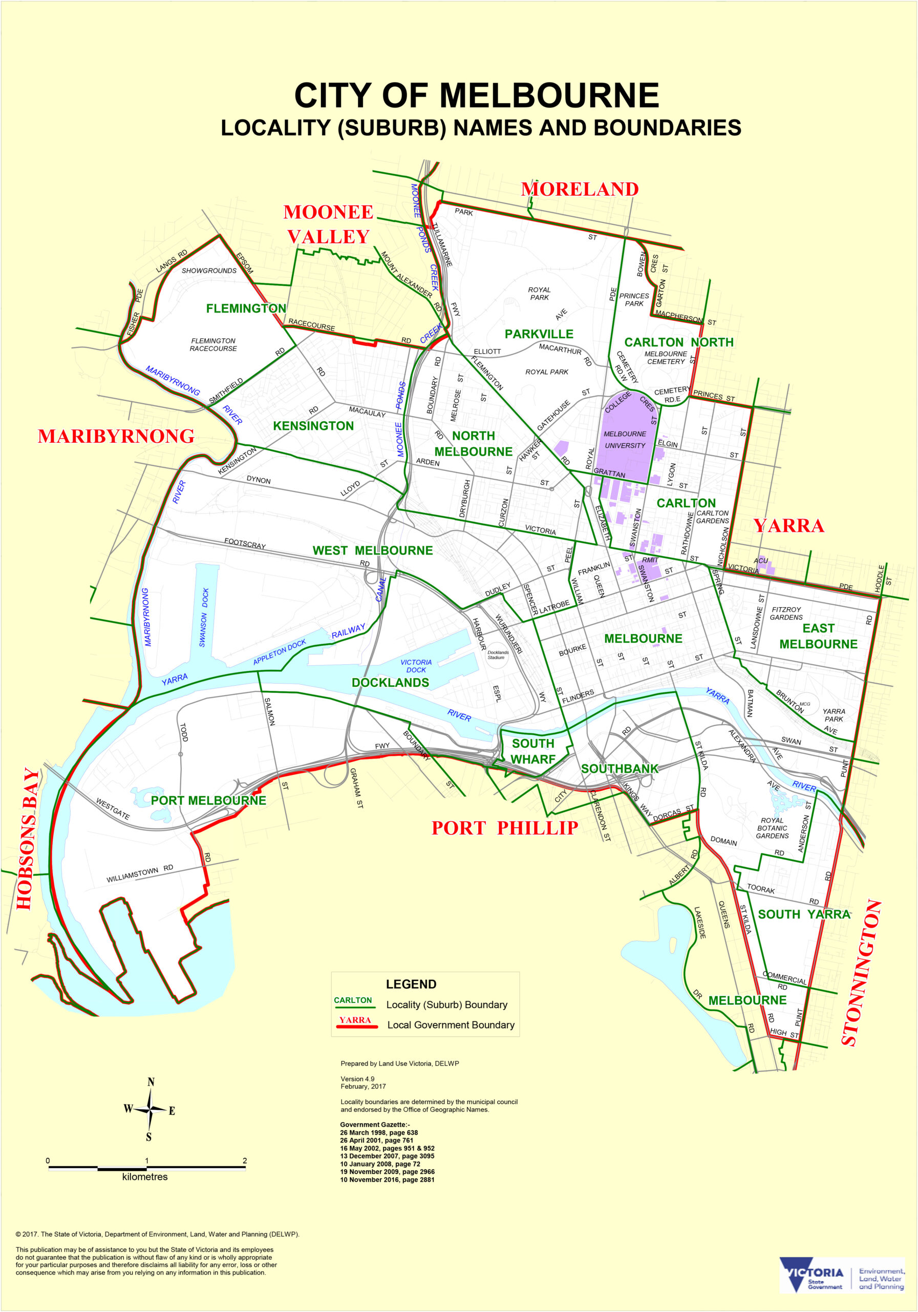
Melbourne was founded in 1835 when settlers arrived by schooner near the present site of Queen’s Wharf, on Wurundjeri Country of the Kulin Nation. The settlement was incorporated as a town in 1842 and elevated to city status on 25 June 1847. Today the LGA covers 37.7 square kilometres and around 177,396 residents (2023), taking in the CBD and a ring of inner suburbs that each wear a different hat: laneway grid, Italian-heritage Carlton, the hospital and university cluster at Parkville, the grand terraces of East Melbourne, and the purpose-built waterfront at Docklands. Flinders Street Station sits at the civic heart with every metropolitan line passing through it, and the Free Tram Zone threads the CBD and Docklands at no cost across 24 routes.
Melbourne CBD
The grid. Wide boulevards, bluestone alleys, and a skyline that has climbed steadily since the 1990s. The CBD is the dense, walkable heart of the city, internationally famous for laneway coffee, theatres, galleries and a shopping offer that mixes Victorian arcades with contemporary high-rise retail. Ride the Free Tram Zone between the CBD, Docklands and Southbank at no charge, and for the celebrated coffee strike out along Degraves Street, Centre Place or Flinders Lane.
Southbank
Cultural armature on the south bank of the Yarra. Southbank was industrial until the 1990s; three decades have rewired it into Melbourne’s arts and hospitality precinct, with the National Gallery of Victoria, Arts Centre Melbourne, the Melbourne Recital Centre and Crown Melbourne strung along a riverside promenade. Admission to the NGV’s permanent collection is free, and the walk from Flinders Street across to South Wharf pays off best in the early evening when city lights hit the water.
Docklands
Purpose-built waterfront, developed from the late 1990s on former industrial land beside the CBD. Docklands is one of Australia’s largest urban renewal projects: high-rise apartment towers, wide promenades, Victoria Harbour, Marvel Stadium, and the retail and dining precincts around NewQuay and The District Docklands. Around 17,700 residents live here. The suburb sits inside the Free Tram Zone, and the flat, bike-friendly harbour walk from NewQuay to Seafarers Bridge is a pleasant way to see it.
Carlton
Italian heritage, student life, UNESCO-scale history. Carlton is nationally known for Lygon Street (Melbourne’s Little Italy), its tree-lined streets of Victorian terraces, and one of Australia’s highest concentrations of university students. Carlton Gardens anchor the cultural end with the Royal Exhibition Building (UNESCO World Heritage-listed) and Melbourne Museum; around 55 per cent of residents were born overseas. Readings on Lygon Street is one of the country’s finest independent bookshops, and tram routes 1 and 8 along Swanston Street drop you in the thick of it.
Parkville
Civic Victorian on a quiet grid. Parkville is residential streets, grand terrace houses, and major institutions: the University of Melbourne’s main campus plus Royal Melbourne, Royal Women’s, Royal Children’s and the Victorian Comprehensive Cancer Centre. Royal Park, at 181 hectares the largest of Melbourne’s inner-city parks, holds Melbourne Zoo. The Route 19 tram runs up Royal Parade, and the zoo is best tackled early on a weekday before school groups arrive.
North Melbourne
Village scale, five minutes from the CBD. North Melbourne is an inner-city pocket with a small-town feel that belies its proximity to Flinders Street: Victorian-era buildings, an industrial past, and leafy residential streets make it persistently coveted. The beating heart is Errol Street, a café and bar strip in heritage shopfronts, and in 2025 Time Out ranked North Melbourne the 24th coolest neighbourhood in the world. The Route 57 or 58 tram along William Street has you there in under 10 minutes from the city.
Flemington
Racecourse famous, multicultural in feel. Flemington is a compact suburb of well-preserved Edwardian and Victorian homes, with Racecourse Road as its multicultural dining heart: Italian, Greek, Egyptian, Somali and South Asian kitchens on a single strip. Flemington Racecourse, home of the Melbourne Cup on the first Tuesday of November, is the headline landmark. The Ethiopian, Somali and Middle Eastern spots along Racecourse Road are worth a deliberate trip for Melbourne’s best-value eating in the inner north, and Newmarket Station puts you in the CBD in under 10 minutes.
Kensington
A village strip with a postcode twin. Kensington shares its postcode with Flemington but has its own character, centred on Pin Oak Crescent: a short strip of independent cafés, bakeries, delicatessens and homewares boutiques among Victorian workers’ cottages. Once a sleeper suburb, Kensington offers solid relative value against its glossier neighbours. Pin Oak Crescent is compact but rewarding on a weekend morning, and Kensington Station on the Craigieburn Line hits Flinders Street in about eight minutes.
East Melbourne
Quietly prestigious, five minutes from Flinders. East Melbourne is one of Melbourne’s most settled addresses: grand Victorian terraces, Art Deco apartments, and tree-lined streets that feel peaceful a short walk from the CBD. Flanking the suburb are Fitzroy Gardens and Treasury Gardens, and the MCG is easily reached on foot. Fitzroy Gardens’ Conservatory has free entry and seasonal flower displays, and the 15-minute walk through the gardens to the MCG is one of the city’s finest match-day rituals.
West Melbourne
A suburb in transition, wearing its industrial bones proudly. West Melbourne mixes wide streets, Victorian cottages, light industrial buildings and adaptive-reuse apartments, shifting from heritage industrial to medium-density residential in real time. Festival Hall, the iconic live music venue, is its most recognisable landmark, and more than 80 per cent of residents now live in apartments. The suburb sits inside the Free Tram Zone and is a flat 10 to 15-minute walk to the CBD via Collins or Bourke Street, with Flagstaff Gardens on the eastern edge.
City of Yarra
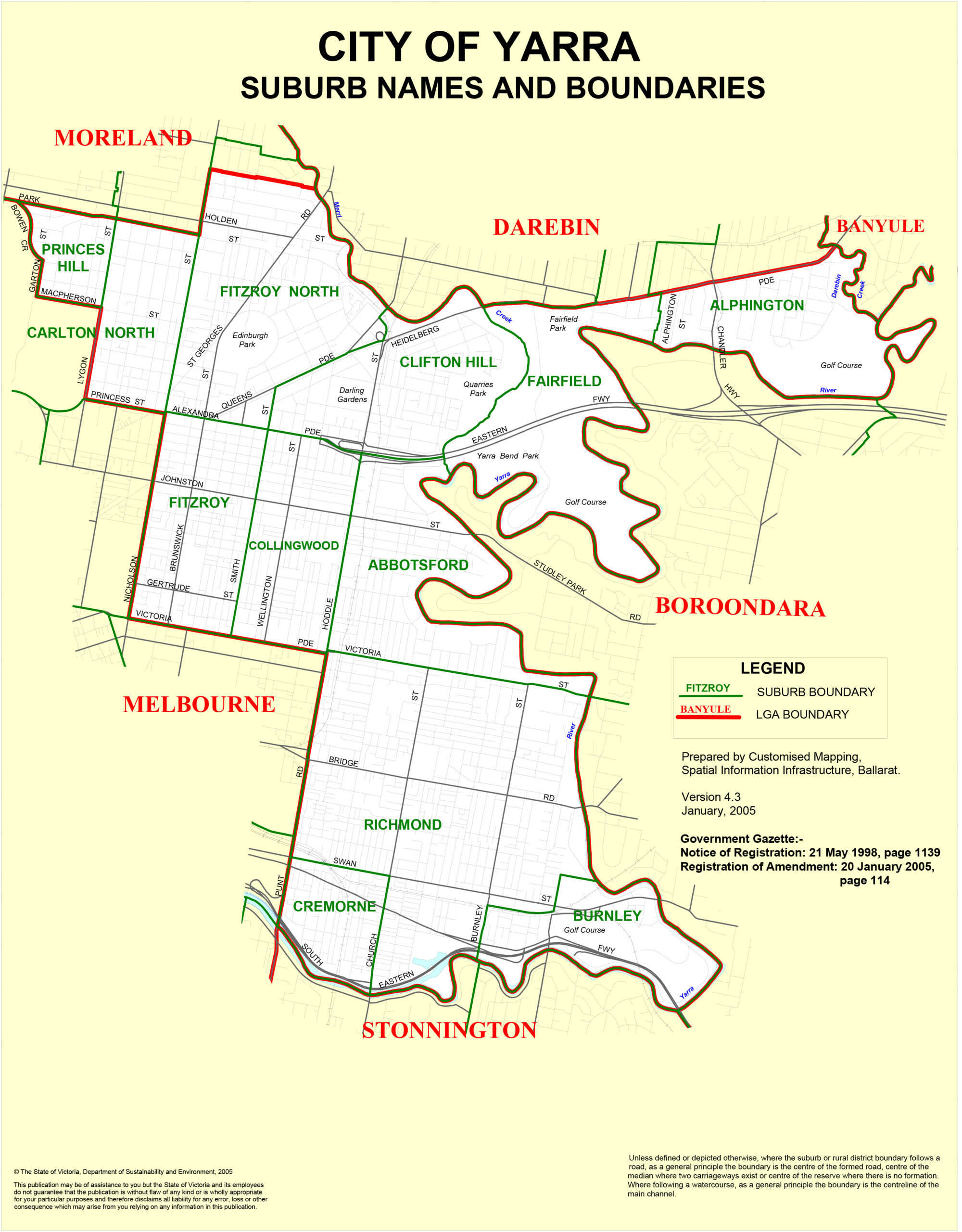
The City of Yarra was formed in 1994 through amalgamation of the former Cities of Richmond, Collingwood and Fitzroy, on Wurundjeri Country. The name Yarra comes from Aboriginal words meaning ‘ever flowing river’. Victorian cottages, terrace rows and Edwardian streetscapes from the 1880s survive in large numbers, and from the 1980s a wave of gentrification brought younger professionals who reshaped Fitzroy, Collingwood and Richmond without entirely scrubbing them clean. Compact at 19.5 square kilometres with 91,543 people (2021), the City of Yarra is the second most densely populated LGA in Victoria: the spiritual home of Melbourne’s arts scene, live music, café and bar sophistication, and two of its great sporting temples (the MCG and AAMI Park) just across the river. Hurstbridge and Mernda trains serve Collingwood, Clifton Hill and North Richmond; Richmond Station is a major interchange; tram routes 86, 12, 48 and 75 thread the rest; and the cycling network is first-rate.
Fitzroy
The original bohemian quarter. Fitzroy is the suburb that gave Melbourne its reputation for café culture, independent bookshops, street art and gently theatrical rebellion. Brunswick Street is the spine: vintage fashion, eccentric bars, organic bakeries and intimate music venues along one walkable strip. Gentrification has polished Fitzroy since the 1980s without smoothing it. Brunswick Street is best on a Saturday morning (coffee, then Polyester Records and Readings), and the Route 86 tram from the CBD drops you on Smith Street, a short walk across.
Fitzroy North
Fitzroy’s quieter, more family-scale sibling. Fitzroy North is a suburb of wide, intact streets laid out in the 1870s, lined with Victorian and Edwardian terrace houses in excellent condition. Edinburgh Gardens, a large inner-city park and former home of the Fitzroy Football Club, is the neighbourhood’s social anchor for weekend sport, picnics and community events. Bring a blanket on a sunny Sunday for Edinburgh Gardens, and the Alexandra Parade to Nicholson Street loop makes an excellent walking circuit through the suburb’s 19th-century architecture.
Collingwood
Inner-north honesty with a Keith Haring on the wall. Collingwood is less polished than Fitzroy, more practical, and arguably all the better for it. Smith Street is its commercial spine (independent cafés, a serious dining scene, galleries, boutiques), while Gertrude Street on the Fitzroy-Collingwood border runs one of the city’s best wine-bar rows. Collingwood is internationally recognised for street art, including a 1984 Keith Haring mural on Johnston Street, one of only 31 surviving Haring works worldwide. Visit on a weeknight for the dining scene without the weekend crush.
Abbotsford
Industrial heritage and a convent turned arts precinct. Abbotsford is small but culturally dense: the Abbotsford Convent, a 6.8-hectare complex on the Yarra River founded in 1864, now operates as Australia’s largest arts and cultural precinct, with studios, galleries, cafés and a popular weekend market. The Collingwood Children’s Farm, the Carlton Brewhouse and the Yarra Trail past Dights Falls give the suburb a surprising rural streak. The Abbotsford Convent market runs on the first and third Sundays of the month, and the Yarra Trail links south to the CBD and Richmond, or north toward Northcote.
Richmond
AFL heartland, Little Saigon, converted warehouses: Richmond fits three suburbs into one. The MCG is a short walk from its western edge, Victoria Street is the destination for Vietnamese food (pho, bánh mì and fresh spring rolls at wallet-friendly prices), and Bridge Road and Swan Street carry the retail and post-match hospitality load. Richmond Station is a major interchange: jump off there for the MCG on game day.
Burnley
Quiet, leafy, often overlooked. Burnley sits between Swan Street and the Yarra River in south Richmond, developed mostly in the Edwardian era, with a family-friendly, park-rich character: Burnley Gardens and the Burnley Golf Course trace the river, and most amenities spill in from Swan Street to the north. Burnley Station is two stops from Flinders Street on the Alamein, Glen Waverley and Lilydale/Belgrave lines, and Burnley Park makes a lovely picnic spot or a starting point for the Capital City Trail.
Cremorne
A fifteen-minute suburb that became a tech industry heart. Cremorne is a pocket so compact you can cross it on foot in a quarter of an hour, wedged between Richmond and the Yarra River with Church Street as its main artery. Once industrial, it has rapidly become Melbourne’s tech and creative cluster (Seek, Carsales and REA Group all headquartered here), with heritage silos and factories reworked into design-led offices and apartments. Church Street is strong on working-lunch cafés, and the suburb is a short tram or cycle to the CBD.
Clifton Hill
Elevated ground, Victorian grid, creekside calm. Clifton Hill sits in the north-east corner of the City of Yarra, sharing postcode and streetscape DNA with Fitzroy North. Laid out by Clement Hodgkinson in the 1870s, it retains an excellent stock of Victorian and Edwardian terrace housing, and it is quieter and more residential than suburbs to its south. The Merri Creek Trail is one of Melbourne’s best off-road cycling and walking routes, linking south to the Yarra River and north to Northcote.
Northcote
High Street, community energy, Merri Creek around the corner. Northcote sits on the City of Yarra and Darebin border, and its identity ties tightly to High Street: yoga studios, live music venues, health food shops and a café scene that has matured without getting corporate. It ranks among Melbourne’s more liveable suburbs, balancing community character, green space and relative affordability against inner-south equivalents. The Northcote Social Club and Westgarth Theatre anchor the live music and cinema scene, and trams along High Street connect quickly to the inner city.
City of Port Phillip
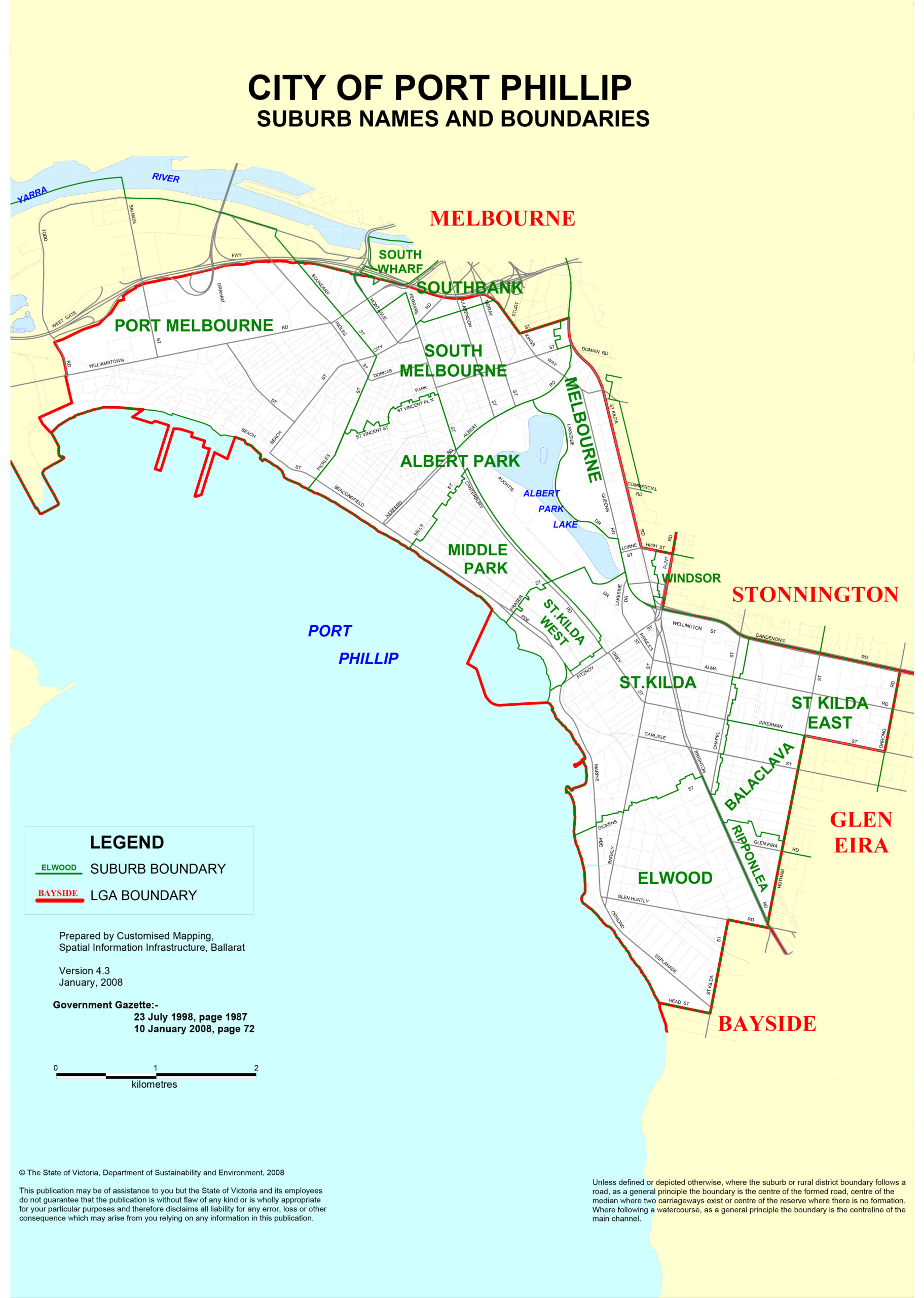
The City of Port Phillip was also formed in 1994, through amalgamation of the former Cities of South Melbourne, St Kilda and Port Melbourne, on Boon Wurrung Country. European settlement began in the 1840s with Melbourne’s first seaport at Port Melbourne (then Sandridge), and cable trams in the late 1880s accelerated development, making St Kilda the city’s premier seaside resort. The LGA covers 20.7 square kilometres and houses 112,669 residents (2024) at roughly 5,474 persons per square kilometre: the most densely populated LGA in Victoria. Character here is defined by the bay, from the cosmopolitan energy of St Kilda’s Fitzroy and Acland Streets to the quiet elegance of Middle Park and the waterfront paths of Port Melbourne. Route 96 light rail (the busiest tram line in the network) runs from the CBD to Acland Street, Route 12 runs via St Kilda Road, the Sandringham line serves Balaclava and Windsor, and the Bay Trail makes Port Melbourne and South Melbourne easy by bike.
St Kilda
Melbourne’s iconic beachside suburb, and its most contradictory. St Kilda has been bohemian, seedy, glamorous and globally celebrated at different points in its history, and today it works as a cosmopolitan destination where backpackers and billionaires share the same Acland Street cake shop. The foreshore strip (Luna Park, the pier, the fairy penguin colony and the Palais Theatre) is the city’s most visited outdoor attraction. The pier penguin viewing is free every evening at dusk: arrive 30 minutes before sunset for a position at the breakwater, and Route 96 from the CBD reaches Acland Street in about 25 minutes.
St Kilda East
St Kilda’s quieter, more residential neighbour. St Kilda East is characterised by Edwardian and Art Deco apartment blocks and a strong Jewish community presence around Carlisle Street. The suburb blends the energy of its famous sibling with a more lived-in, neighbourhood-scale atmosphere, and Carlisle Street has quietly built one of the city’s best café, bakery and casual-dining strips. Carlisle Street is underrated (quieter and more authentic than Acland Street), and Balaclava Station on the Sandringham line puts the CBD about 15 minutes away.
South Melbourne
One of Melbourne’s oldest and most liveable suburbs. South Melbourne sits just two kilometres from the CBD, with Clarendon Street as its commercial spine and the much-loved South Melbourne Market at its core. The streets mix distinctive Victorian architecture with modern apartment builds, attracting professionals and families who value inner-city convenience and a workable neighbourhood scale. South Melbourne Market runs Wednesday, Friday, Saturday and Sunday, and the Saturday morning dim sim from the market’s long-running stall is a Melbourne institution worth building a weekend around.
Port Melbourne
Melbourne’s first seaport, now a waterfront neighbourhood. Port Melbourne (originally Sandridge) holds the distinction of being the city’s earliest seaport, established in the mid-19th century. Today it blends maritime heritage with contemporary bayside living: the Bay Trail foreshore walk, views across Port Phillip Bay, a growing café culture along Bay Street, and high-quality residential development along the water. The Bay Trail traces the foreshore all the way to St Kilda and beyond, one of the best flat walking or cycling routes in the city, and Bay Street has a solid cluster of cafés for a weekend morning.
Albert Park
Wide streets, London Plane trees, a Grand Prix circuit around a lake. Albert Park is an inner suburb of consistent heritage character, centred on Albert Park Lake: a 225-hectare reserve hosting the Albert Park Golf Course, the Melbourne Sports and Aquatic Centre, and the Albert Park Circuit used for the Australian Formula 1 Grand Prix each March. Dundas Place is the village dining strip. The 4.7-kilometre lake track is free, flat and popular with morning exercisers; during the Grand Prix in March, book restaurants well ahead.
Middle Park
Calm coastal-village energy between Albert Park and St Kilda. Middle Park is leafy, family-oriented and architecturally stately, with Victorian homes, the Beaconsfield Parade foreshore promenade, and the intimate Armstrong Street café strip carrying everyday life. Property values are among the highest in Port Phillip. Armstrong Street is an ideal spot for a slow weekend breakfast, and the foreshore walk along Beaconsfield Parade between Middle Park and St Kilda ranks among the city’s most pleasant early-morning routes.
Elwood
Bayside community with a strong family streak. Elwood is characterised by Edwardian and Interwar architecture, leafy streets lined with London Plane trees, and a beach that windsurfers, cyclists and families treat as their summer backyard. Ormond Road and Ormond Esplanade form the café and dining spine, and the suburb has a tight-knit community culture distinctly different from nearby St Kilda. Elwood Beach is quieter than St Kilda Beach and a better pick for families; Elsternwick Station on the Sandringham line or the Route 67 tram provide access.
Balaclava
Compact inner suburb with a strong Jewish community identity. Balaclava has been shaped by a large Orthodox Jewish population: kosher restaurants, Jewish bakeries, visible Shabbat observance, and specialist Jewish schools give the suburb a particular rhythm and streetscape. It takes its name from the Battle of Balaclava (1854), and Balaclava Station on the Sandringham line makes the commute easy. Many kosher establishments close on Saturdays (Shabbat), so a weekday or Sunday visit shows the suburb at its busiest.
Ripponlea
Small, quiet, and home to a heritage mansion you can actually visit. Ripponlea is known for its Jewish heritage, handsome period homes, and the Ripponlea Estate: a National Trust-classified Victorian-era mansion and garden open to the public. The suburb is predominantly residential, with Glen Eira Road forming the main commercial strip at its edges, and Ripponlea Station on the Sandringham line puts Flinders Street roughly 15 minutes away. The estate gardens reward a slow wander, particularly in spring.
Frequently Asked Questions
What is Melbourne’s Inner Metro Region?
Melbourne’s Inner Metro Region comprises three local government areas: the City of Melbourne, the City of Yarra, and the City of Port Phillip. Together they cover about 77 square kilometres and house more than 337,000 residents. The region stretches from Flemington and Kensington in the north-west through the CBD to the Port Phillip Bay foreshore at St Kilda and Port Melbourne. See here for a broader view of the larger Melbourne Metropolitan area.
Which Melbourne inner suburb is best for visitors?
It depends on what you are after. For heritage laneways and café culture, the CBD and Fitzroy are unmissable. For a beachside experience, St Kilda is the classic choice. For food, Collingwood’s Smith Street, Carlton’s Lygon Street, and Richmond’s Victoria Street are all excellent. Southbank is ideal if you are visiting arts institutions like the NGV.
What is the difference between Fitzroy and Collingwood?
Fitzroy (centred on Brunswick Street) is Melbourne’s original bohemian neighbourhood: slightly more polished, with a stronger arts and alternative heritage. Collingwood (centred on Smith Street) is less polished, more practical, and has a denser food and nightlife offering. Both are excellent for dining, bars and street art.
Is public transport good in Melbourne’s inner suburbs?
Yes. The CBD is covered by the Free Tram Zone, trams radiate out to all inner suburbs, and metropolitan train lines connect Flinders Street Station to Richmond, Collingwood, Clifton Hill, Balaclava and other inner stations. All public transport uses the Myki card system.
Where is St Kilda and how do I get there?
St Kilda is six kilometres south-east of the Melbourne CBD in the City of Port Phillip. The easiest way in is the Route 96 light rail tram from the CBD, which takes about 25 minutes to Acland Street. The nearest train stations are Balaclava (Sandringham line) and Windsor.
Where can I see fairy penguins in Melbourne?
Little (fairy) penguins can be seen at the St Kilda Pier breakwater most evenings at dusk. Viewing is free and managed by volunteer rangers. Arrive 20 to 30 minutes before sunset, and note that flash photography is prohibited.
What is the City of Yarra known for?
The City of Yarra is Melbourne’s cultural and sporting heartland: it contains Fitzroy and Collingwood’s café and arts precincts, the MCG, Victoria Street Richmond’s Vietnamese restaurant strip, the Abbotsford Convent, and the Yarra River trail. It is the second most densely populated LGA in Victoria.
Which suburb is best for new residents moving to inner Melbourne?
For café culture and creative energy, try Fitzroy or Collingwood. For community and relative affordability, consider North Melbourne or Kensington. For quiet, leafy prestige, East Melbourne or Middle Park make sense. For bayside living, Elwood or Port Melbourne. For student and academic life, Carlton or Parkville.
Take the Inner Metro Region one strip, one tram line and one coffee at a time; it reveals itself faster on foot than it ever will from a map.
References
- DataVIC – https://www.data.vic.gov.au – map data
- City of Melbourne – https://www.melbourne.vic.gov.au – map data, CBD information