
Four local government areas, roughly 160 square kilometres, and some of Melbourne’s most coveted postcodes. The Inner South East stretches from South Yarra’s boutique strips and Hawthorn’s elm canopy across Boroondara’s private-school belt, through Glen Eira’s culturally layered residential grid, and out to Bayside’s Port Phillip foreshore where painted bathing boxes have become shorthand for a particular kind of Melbourne life. Elm-canopied streets, football clubs with waiting lists, private schools at every second corner, and a café culture that takes itself just seriously enough.
This guide covers all four LGAs and every suburb within them. Whether you are deciding where to stay, weighing up a move, or just trying to decode which side of Glenferrie Road belongs to which council, you will find a plain-English portrait, a practical transport note, and the kind of local detail that takes years to accumulate.
Melbourne Inner South East Map
Inner & Bayside Legend
City of Stonnington
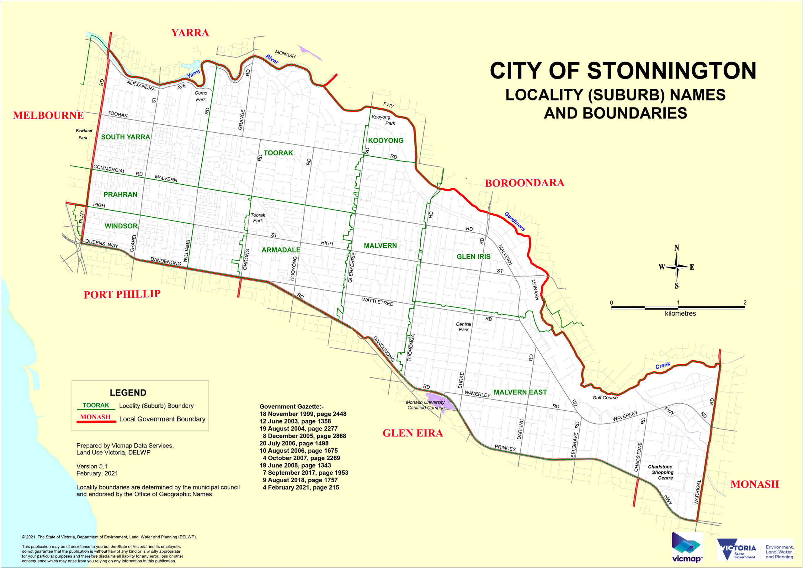
The City of Stonnington was formed in 1994 from the Cities of Malvern and Prahran, on Boon Wurrung and Wurundjeri Country. It takes its name from Stonington Mansion in Malvern, a grand 1890 residence named after Stonington, Connecticut. At 25.7 square kilometres with a median resident age of 35, Stonnington runs from the Royal Botanic Gardens edge to Gardiners Creek, holding Chapel Street, Glenferrie Road, High Street and Toorak Road: corridors that have been commercially significant long enough to feel inevitable.
South Yarra
Leafy, fashionable, and comfortable with itself. South Yarra flanks the Royal Botanic Gardens on Domain Road (walk it in autumn when the plane trees turn gold) and stretches south to where Chapel Street gets more interesting. Toorak Road in between is the quiet register: boutique wine shops, independent cafes, actual tablecloths. Tram routes 8 or 72 from Flinders Street; or walk through the gardens in twenty minutes.
Prahran
Lively, opinionated, and good at lunch. Prahran is the loudest section of Chapel Street, anchored by the Prahran Market on Commercial Road: one of Melbourne’s oldest fresh-food markets, quality over footprint, no mass-produced stall-filler. Market days are Tuesday, Thursday, Friday and Saturday; Saturday before 9am is the optimal window.
Windsor
The grittier, younger sibling at the southern end of Chapel Street. Windsor ranked tenth on Time Out’s global coolest neighbourhoods list: independent music venues, low-key bars, and self-possession earned from years of being overlooked. Greville Street provides a second thread. Windsor Station (Sandringham line) drops you at the action; the suburb reads better at night.
Toorak
Melbourne’s reference point for residential prestige. Grand mansions, immaculate gardens, elite private schools and Toorak Road’s luxury-brand mile. The streetscape rewards a drive more than the reputation suggests. Toorak Road trams (routes 8 and 72) run frequently; parking is competitive enough that transit makes more sense.
Malvern
Quality and heritage without flash. Malvern centres on Glenferrie Road: boutique shops, cafes and grand Victorian and Federation homes, with some of Melbourne’s better-known private schools nearby. The suburb has been desirable long enough to be completely uninterested in proving it. Malvern Station (Alamein line) is the easiest entry.
Malvern East
A shade more relaxed than Malvern, with better green space. Malvern East has Hedgeley Dene Gardens (a heritage-listed reserve of native and exotic plantings), Central Park, and the enormous gravitational fact of Chadstone Shopping Centre (the Southern Hemisphere’s largest) at its eastern edge. Gardiner Station (Glen Waverley line) covers the northern end; direct buses from Darling Station reach Chadstone without the weekend car-park ordeal.
Armadale
Armadale is where Melbourne’s serious boutique fashion lives. High Street is a premier retail strip for fashion, homewares and antiques, set among Victorian and Edwardian homes with elm cover. Union Street Gardens provides a quiet counter to the shopping energy. High Street trams (route 6) run frequently; Saturday morning is the optimal retail window.
Glen Iris
Glen Iris straddles the Boroondara and Stonnington boundary, with Gardiners Creek defining the split. The Stonnington portion is settled and family-focused, with Ferndale Park and the creek trail as its green backbone. The Alamein line passes through; the Gardiners Creek Trail connects west toward the Yarra River, one of the better off-road cycling corridors in the inner south-east.
Kooyong
Small and exclusive, internationally recognised for the Kooyong Lawn Tennis Club: the spiritual home of Australian tennis, host of the Australian Open before it moved to Melbourne Park, and now home to the Kooyong Classic ATP warmup each January. The suburb around it is residential and quiet. The Classic sells out; check the August schedule and book early.
City of Boroondara
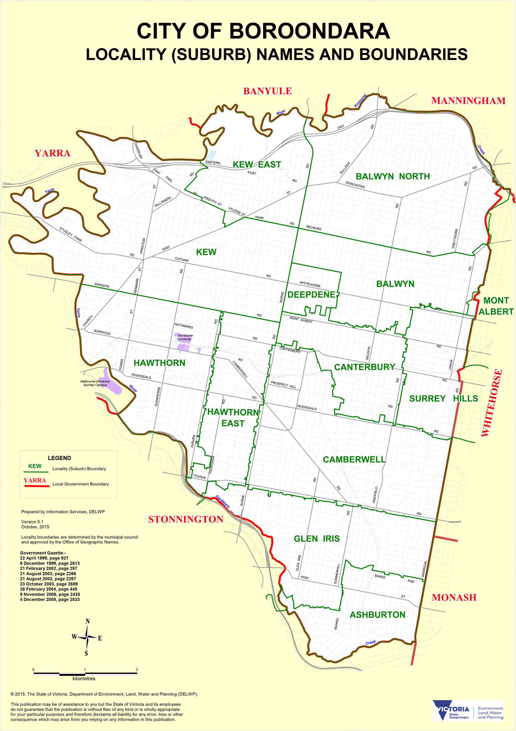
Boroondara takes its name from the Woiwurrung language, meaning ‘where the ground is thickly shaded’, and the elm and oak canopy earns that description still. Surveyor Robert Hoddle declared it the Parish of Boroondara in 1837, on Wurundjeri Country; the current council was formed in 1994 from the Cities of Kew, Camberwell and Hawthorn. At 60 square kilometres with a population of 167,903 (2021 Census), it is the largest of the four Inner South East LGAs. Nearly 30 per cent of residents were born overseas, tracing heritage to more than 150 countries. Alamein, Glen Waverley, Belgrave and Lilydale train lines thread through; trams run on Toorak Road, Glenferrie Road, Burke Road and Whitehorse Road.
Hawthorn
Hawthorn runs on Glenferrie Road: cafes, boutiques and bookshops under a consistent elm canopy, with Swinburne University adding student energy to the north. Home to the Hawthorn Football Club and the school-belt (Scotch College, Xavier, Methodist Ladies’). Glenferrie Station sits right on the strip; Hawthorn Arts Centre has free exhibitions worth checking.
Hawthorn East
Quieter than central Hawthorn, with the same Edwardian and 1920s intelligence. Hawthorn East appeals to families, downsizers and young professionals seeking school access without the Camberwell Junction price tag. Trams on Burke Road and Riversdale Road; Camberwell Station is a short walk east.
Camberwell
Camberwell Junction is one of Melbourne’s most satisfying shopping destinations: a hilly period-shopfront strip with an indoor fresh-food market, excellent restaurants, Readings bookshop, and one of the city’s best suburban public libraries. The surrounding streets are quintessential established Melbourne: grand homes, deep blocks, serious tree cover. The Camberwell Sunday Market runs in the Station Car Park most Sundays; arrive before 10am for the best of it, after which the car park becomes more about the car than the market.
Canterbury
One of Melbourne’s most exclusive residential addresses, old-money in character without effort. Grand Federation and Edwardian homes on generous allotments, limited commercial intrusion, and Maling Road as the village strip: cafes, bookshops, specialty food. Canterbury Station is a short walk; Maling Road on a Saturday morning is as pleasant as suburban Melbourne gets.
Balwyn
Almost entirely residential, consistently among Victoria’s most expensive suburbs. Leafy streets, a significant Chinese-Australian community, and a school zone with serious gravitational pull: several of Melbourne’s best private and public schools are within reach. Whitehorse Road is the main retail strip; bus-dependent, but the blocks are generous and streets quiet.
Balwyn North
Developed in the 1950s and 1960s, Balwyn North retains large blocks, quiet streets and a family-oriented character. Balwyn High School ranks among Victoria’s top public schools; the catchment is a significant factor in property demand. Bus routes serve the area; minimal commercial development means the suburb is residential in character without distraction.
Kew
Seven kilometres from the CBD with institutional confidence earned over a century. Affluent, well-treed and dense with private schools (Trinity Grammar, Ruyton Girls’, Xavier). Cotham Road is worth a slow drive; Kew Boulevard above the Yarra has views worth the detour. The 109 tram on Collins Street is the standard CBD connection.
Kew East
Kew’s eastern neighbour shares the same affluent character and school proximity, with a quieter, more suburban pace. Period homes are well-maintained; bus routes along Burke Road connect to the CBD, and the Eastern Freeway is close for drivers.
Deepdene
One of Melbourne’s smallest named suburbs, tucked between Kew, Balwyn and Camberwell. Almost entirely residential, with Deepdene Park and the Deepdene Trail as the green anchor. Well-kept and discreet; bus routes on Burke Road are the main connection.
Surrey Hills
Heritage village feel grounded in architectural fact: Federation, Edwardian and interwar homes give Surrey Hills a consistent character. Union Road and Canterbury Road carry the café and retail strip with genuine community energy. Surrey Hills Station serves four train lines; compact, walkable and relatively unselfconscious about being as good as it is.
City of Glen Eira
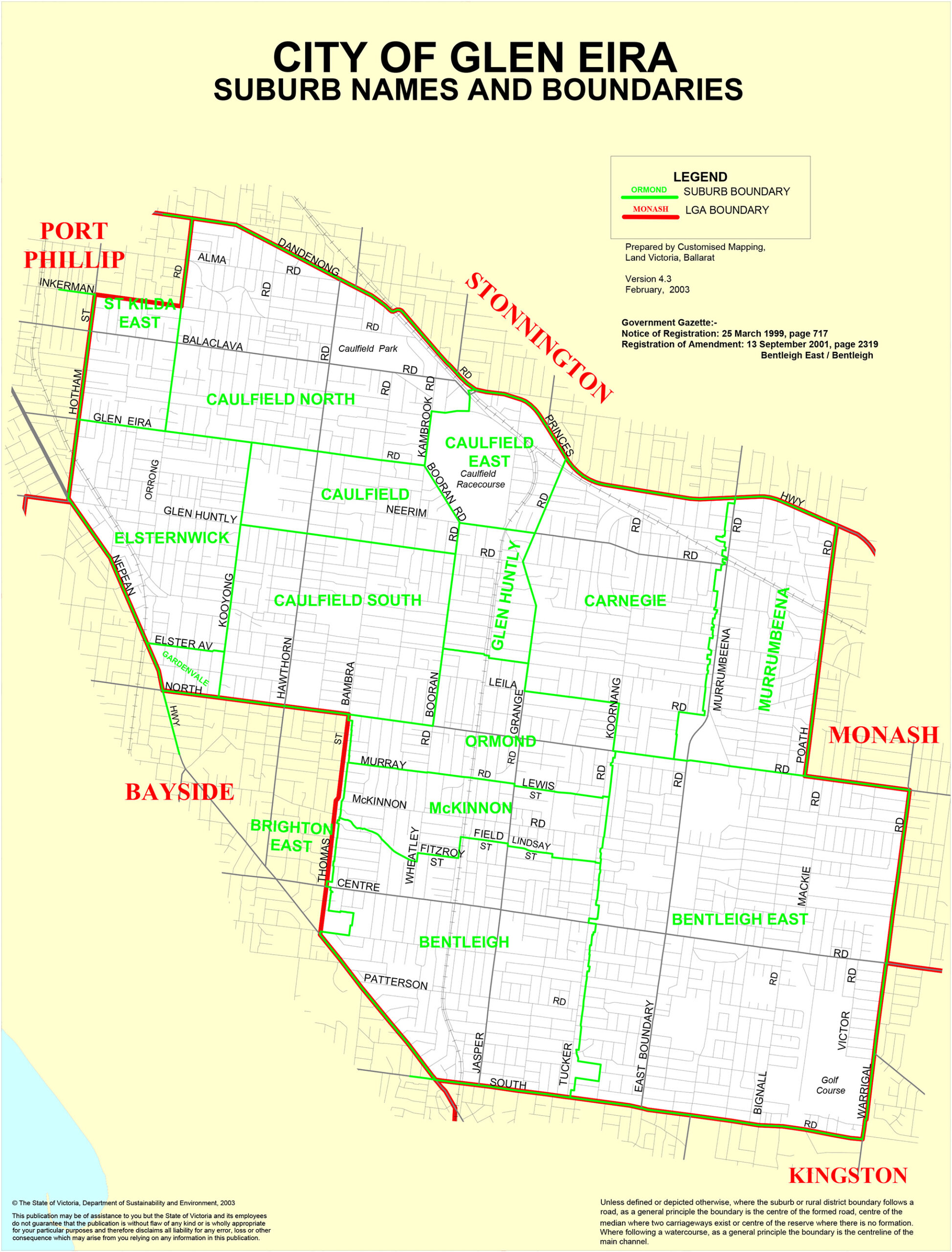
The City of Glen Eira was formed in 1994 from the City of Caulfield and parts of the City of Moorabbin, taking its name from Glen Eira Road and the nearby mansion. It covers 39 square kilometres on Boon Wurrung Country with an estimated population of 153,858. Glen Eira’s most distinctive characteristic is its Jewish community: at the 2011 Census, 54.9 per cent of all Victorian Jews lived in the LGA, concentrated in Caulfield, Caulfield North, Elsternwick and St Kilda East. Broadly diverse overall, 36 per cent of residents were born overseas. The Frankston and Sandringham train lines, with trams on Glen Huntly Road, Hawthorn Road and North Road, provide the transit backbone.
Caulfield
Shaped by its racecourse and its community. Caulfield Racecourse hosts the Caulfield Cup in October and operates as a major event venue year-round. The surrounding streets carry Glen Eira’s Jewish community character: kosher restaurants, specialist bakeries, and a rhythm that shifts around Shabbat. Caulfield Station is a major interchange; Monash University’s Caulfield Campus is within walking distance.
Caulfield North
An upmarket residential pocket with roots in the 1880s mansion era. Some of Glen Eira’s grandest heritage homes, a strong Jewish community presence, and a low-profile character. Trams on Hawthorn Road (routes 64, 67) are the main public transport link.
Caulfield South
Quieter and more residential than Caulfield North, with good Elsternwick Park access. Families value the parks, solid school options and moderate prices relative to the north end. Trams on Glen Huntly Road and North Road cover the east-west corridors.
Caulfield East
Predominantly residential, Caulfield East sits between the racecourse precinct and Carnegie’s commercial strip. Practical and well-connected without the price premium of Caulfield North; Carnegie Station on the Frankston line is the main rail access point.
St Kilda East
Shared between Glen Eira and Port Phillip, St Kilda East has a strong identity distinct from its famous neighbour. Edwardian and Art Deco apartments, a large Jewish community, and Carlisle Street’s quietly excellent strip of cafes, bakeries and casual restaurants. Balaclava Station (Sandringham line) provides rail access; Carlisle Street is less crowded and more authentic than Acland Street.
Elsternwick
One of Glen Eira’s most characterful suburbs. Strong café and deli culture on Glen Huntly Road, a Jewish community hub, and the Rippon Lea Estate as its cultural centrepiece: a National Trust-listed Victorian mansion and garden open to the public, worth a deliberate visit in spring. Elsternwick Station (Sandringham line) is about 20 minutes from the CBD.
Gardenvale
A quiet residential suburb between Elsternwick and Brighton, with well-maintained interwar homes and a settled neighbourhood feel. North Brighton Station (Sandringham line) provides easy access without the foreshore premium.
Bentleigh
Bentleigh has one of Glen Eira’s most active commercial centres on Centre Road: cafes, restaurants, shops and community services. A strong stock of Californian bungalows, many on the heritage register. Bentleigh Station (Frankston line) sits on Centre Road; the weekend energy here has an authenticity that more prestigious suburbs north sometimes lack.
Bentleigh East
Classic postwar suburban Melbourne: large blocks, open gardens, solid schools and Westfield Southland proximity. Increasingly popular with families for school access and relative affordability. Centre Road trams serve it; a car is useful for the wider grid.
Carnegie
Glen Eira’s most genuinely multicultural suburb, and Koornang Road is the evidence: Korean BBQ, Vietnamese bakeries, Indian grocers and independent cafes from half a dozen communities, coexisting without ceremony. Carnegie Station (Frankston line) makes it easy from the CBD. Go for dinner; the Korean restaurants punch above their postcode.
Murrumbeena
A settled interwar suburb with solid parkland and quiet streets. Murrumbeena Park gives it genuine green credentials, and Murrumbeena Station (Frankston line) provides direct CBD services. Well-positioned between Carnegie and Ormond for day-to-day amenities.
Ormond
Predominantly residential with an interwar character. Ormond has a small commercial strip on North Road and good Monash Freeway access. Ormond Station (Frankston line) is direct to Flinders Street; Central Park makes a solid weekend walk.
Glen Huntly
A compact suburb with a local-scale shopping strip on Glen Huntly Road. Diverse community, older apartment stock and period homes. Practical and well-connected for those wanting inner-south access without inner-south prices; Glen Huntly Station (Frankston line) and trams connect north toward the city.
McKinnon
Small, quiet and sought-after for McKinnon Secondary College, consistently one of Victoria’s top-performing public schools. Outside the catchment question it is a pleasant suburb of period homes and McKinnon Reserve. McKinnon Station is on the Frankston line; check zoning boundaries carefully if catchment matters, as they are strictly applied.
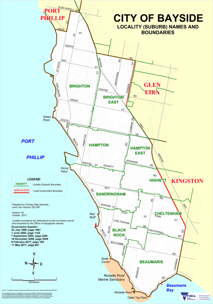
City of Bayside
The City of Bayside was formed in December 1994 from the Cities of Brighton and Sandringham, and parts of Mordialloc and Moorabbin, on Boon Wurrung Country. European settlement began in 1841 when Henry Dendy purchased a ‘special survey’ covering what is now Brighton, Brighton East, Bentleigh and McKinnon. The council covers 36 square kilometres with a population of approximately 105,718, stretching 8 to 20 kilometres south of the CBD along Port Phillip Bay. The bay is not decorative: it is the organising principle of the LGA. Beaches, foreshore paths, yacht clubs, golf courses and the Brighton bathing boxes all anchor daily life. The Sandringham line is the main rail artery; trams serve Nepean Highway.
Brighton
Melbourne’s quintessential bayside address. Brighton is Church Street’s premium retail, the 82 rainbow-painted bathing boxes on Brighton Beach (among the most photographed images in Victoria, privately owned), elite private schools, and the Royal Brighton Yacht Club. The foreshore in the early morning is worth the early alarm. Brighton Beach Station is closest to the bathing boxes; North Brighton Station serves Church Street.
Brighton East
Brighton East has the leafy prestige without the foreshore price. Federation and Edwardian homes, excellent schools and Elsternwick Park proximity make it a practical family choice. Gardenvale and Elsternwick stations (Sandringham line) cover the northern part; bus routes serve the interior.
Hampton
Relaxed and community-oriented between Brighton and Sandringham. Hampton Street is a solid village-scale café and shopping strip with real local character; the beach and foreshore path give it easy outdoor quality year-round. Hampton Station (Sandringham line) is central; the foreshore walk north to Brighton or south to Sandringham is flat and consistently good.
Hampton East
A post-war residential suburb in gradual transition, with original homes on large blocks increasingly giving way to townhouses. Family-friendly feel, good access to Hampton Street amenities without the beachfront premium. No train station; buses connect to Hampton and Moorabbin.
Sandringham
Sixteen kilometres south of the CBD, Sandringham is anchored by Sandringham Village: cafes, restaurants and boutique shops around the station that feel like a coastal town rather than a suburb. Period homes, a working yacht club, a beach that draws locals rather than day-tripping crowds. Sandringham is the terminus of its line; express services from Flinders Street run in around 30 minutes.
Black Rock
Genuine coastal drama that more northern suburbs trade for prestige. Red Bluff, a cliff of oxidised iron in burnt orange tones, is the suburb’s most striking feature; the foreshore below is excellent for swimming and kayaking. Quiet, community feel, strong period architecture. Bus route 709 from Sandringham; Red Bluff at low tide gives full beach access.
Beaumaris
The southernmost Bayside suburb and among the most naturally compelling. Beaumaris has clifftop views over Port Phillip Bay and an unusual architectural heritage: a well-preserved collection of mid-century modernist homes from the 1950s to the 1970s, rare and largely intact in the Australian context. Native vegetation reserves and coastal walking trails complete the picture. Bus-only; the cliff walk from Black Rock is free and excellent.
Cheltenham
A suburb in active transition: Westfield Southland (one of Melbourne’s largest shopping centres, opened 1968) anchors the commercial core, while surrounding streets see steady renovation and new medium-density builds. Good transport and relative affordability make Cheltenham increasingly popular with younger families. Cheltenham Station (Frankston line) sits adjacent to Southland.
Highett
Split between Bayside and Kingston, Highett is a post-war suburb whose trajectory has moved upward for a decade, drawing younger families and professionals to renovate older stock. Highett Station (Sandringham line) is well-connected; reasonable value relative to Hampton and Sandringham for those who can live without immediate foreshore access.
Moorabbin (part)
Only part of Moorabbin falls within Bayside (the remainder is Kingston). The Bayside portion is residential and practical, close to Westfield Southland and the Cheltenham amenity cluster. Bus routes on Nepean Highway and Moorabbin Station on the Frankston line are the main transit links.
Frequently Asked Questions
What is Melbourne’s Inner South East Region?
Four local government areas: the City of Stonnington, the City of Boroondara, the City of Glen Eira and the City of Bayside. Together they cover roughly 160 square kilometres from the boutique strips of South Yarra and Hawthorn to the Port Phillip Bay foreshore at Brighton, Sandringham and Beaumaris.
Which suburb is best for a bayside holiday base?
Sandringham offers the best balance of coastal access, a village-scale dining strip and direct train access to Flinders Street in around 30 minutes. Brighton is more prestigious and more expensive; Beaumaris is quieter and more scenic but is bus-only. Hampton is an excellent middle option with a solid café strip and good foreshore walking.
What is Chapel Street and where does it run?
A 4.3-kilometre retail, dining and nightlife corridor through South Yarra, Prahran and Windsor. The South Yarra end is upscale; the Prahran middle is lively and food-focused; the Windsor southern end is younger and more independent. Tram route 78 runs the full length.
Where are the Brighton Beach bathing boxes?
The 82 bathing boxes line the Brighton foreshore, south of Dendy Street Beach. They are privately owned, colourfully painted, and among the most photographed landmarks in Victoria. Brighton Beach Station on the Sandringham line is the closest stop; the foreshore promenade is freely accessible at all times.
Where is the Kooyong Lawn Tennis Club?
In Kooyong, City of Stonnington, roughly 5 kilometres south-east of the CBD. The club hosted the Australian Open before it moved to Melbourne Park, and now hosts the Kooyong Classic ATP warmup each January. Tickets sell quickly; check the August schedule.
Which suburb is best for multicultural dining in the south-east?
Carnegie’s Koornang Road is the standout: Korean, Vietnamese, Indian and Chinese restaurants along a walkable strip, served directly by Carnegie Station on the Frankston line. Elsternwick on Glen Huntly Road is excellent for Jewish delis and Middle Eastern food. Caulfield has strong kosher dining options concentrated along Caulfield Road.
Where is Melbourne’s Jewish community concentrated?
Primarily in the City of Glen Eira, concentrated in Caulfield, Caulfield North, Elsternwick and St Kilda East. At the 2011 Census, 54.9 per cent of all Victorian Jews were recorded as living in Glen Eira.
Is public transport good in the Inner South East?
It varies. Stonnington is well-served by trams and the Sandringham, Alamein and Glen Waverley lines. Glen Eira has the Frankston and Sandringham lines with trams filling gaps. Boroondara’s inner suburbs have solid coverage; outer Balwyn North is more car-dependent. Bayside’s Sandringham line reaches Hampton; buses cover Black Rock and Beaumaris.
What makes Boroondara different from Stonnington?
Boroondara is larger, extending further north and east, with a more suburban scale in even its inner suburbs. Stonnington is denser and more urban, containing Chapel Street, Melbourne’s most commercially active inner-south corridor. Both share affluent, leafy character and private-school culture; Boroondara’s Hawthorn, Kew and Camberwell carry a slightly more established identity than Stonnington’s Toorak and Armadale.
Which Bayside suburb has the most interesting architecture?
Beaumaris, without competition. The suburb has an unusually intact collection of mid-century modernist homes built from the 1950s through the 1970s, a period and style that was largely demolished elsewhere in Melbourne’s suburbs. Brighton has grand Victorian and Edwardian heritage; Sandringham has a solid period village character; but Beaumaris is genuinely distinctive in the Australian context.
The Inner South East rewards familiarity. Take one suburb at a time, on foot where the trams go and by bike where the creek trails allow; the region gives itself up slowly, one café and one heritage streetscape and one foreshore walk at a time.