
Melbourne’s west has always done its own thing. While the inner east earned its reputation on coffee and gallery openings, the west was busy building the city’s actual industrial backbone, absorbing wave after wave of migration, and quietly developing a character that no amount of gentrification can smooth away. The result is a stretch of suburbs that ranges from maritime heritage towns and multicultural food corridors to some of the fastest-growing residential communities in Australia.
Six local government areas form what planners call Melbourne’s Western Region: Maribyrnong, Moonee Valley, Hobsons Bay, Brimbank, Wyndham and Melton. Together they cover an enormous arc from the inner suburbs 5 kilometres west of the CBD all the way out to the rural fringe at Little River, nearly 60 kilometres from the city. That arc contains more geographic and demographic variety than most visitors expect. This guide works through each LGA and its key suburbs so you know what you are heading into before you arrive.
Melbourne Western Region Map
Note: based on electorate boundaries.
Western Region Legend
City of Maribyrnong
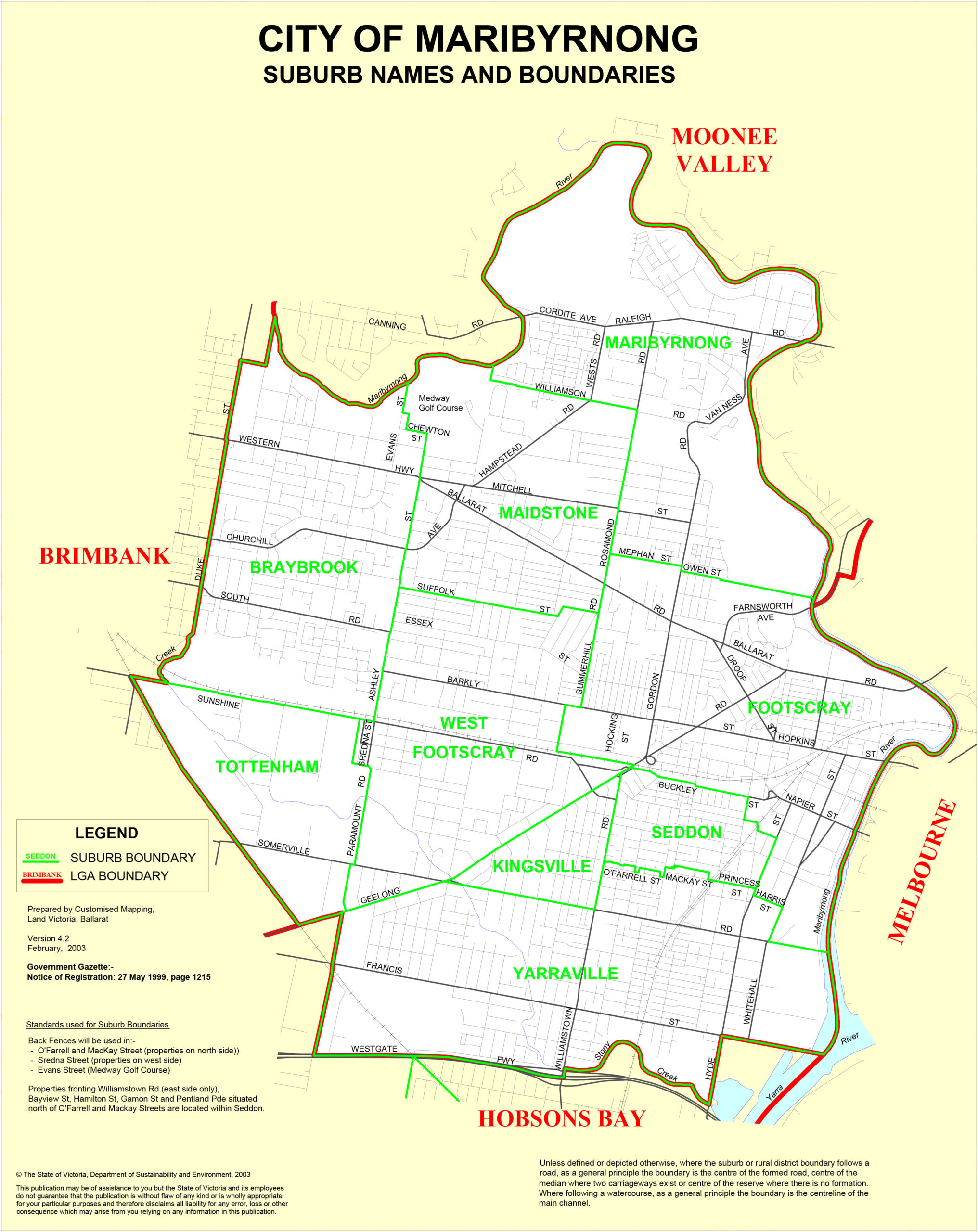
Maribyrnong was formed in 1994 from the former City of Footscray and parts of the City of Sunshine, and it covers the inner western suburbs roughly 5 to 10 kilometres from the CBD. The Maribyrnong River forms the western boundary and the council’s most prized recreational asset: the river trail runs through parkland, past wetlands and industrial remnants, connecting suburbs that once turned their back on the water. Post-war migration shaped the character of the area more profoundly than any planning decision ever could. Greek, Italian and Yugoslav communities arrived first, Vietnamese and East African communities followed, and the resulting food culture is arguably the city’s most genuinely diverse. Heritage workers’ cottages, now eagerly sought after, line the streets of the inner suburbs, and the arrival of microbreweries, creative studios and converted industrial spaces has layered a newer identity on top of the old without erasing it.
Footscray
Footscray sits 5 kilometres west of the CBD and carries its multicultural identity without any self-consciousness. The market opposite the station is where you understand the suburb most quickly: Vietnamese pho joints, Pinoy kiosks and a Sicilian cannoli shop (T. Cavallaro and Sons, making the same recipe since 1956) operating within metres of each other. Time Out placed Footscray 13th in its 50 Coolest Neighbourhoods in the World in 2019, and the suburb has continued to evolve since then. Head to Hopkins and Leeds Streets for the city’s best pho, and look for Nhu Lan for banh mi that rivals anything you would find in Ho Chi Minh City.
Seddon
Seddon is 7 kilometres west of the CBD and rewards patience. Its tree-lined streets of Victorian and Edwardian cottages are quieter than Yarraville’s, its wine bars and independent cafes a little less conspicuous, and its entry prices a step more accessible. Young families and first-time buyers have made it their own precisely because it offers the inner-west lifestyle without the premium. Victoria Street is the main strip for coffee and weekend browsing.
Yarraville
Yarraville Village is the inner west’s most coherent precinct, 6 kilometres from the CBD and genuinely walkable in a way few Melbourne suburbs manage. The Art Deco Sun Theatre (built 1938, restored faithfully) anchors the main strip, with acclaimed restaurants, artisan cafes and independent boutiques radiating out from it. Families and young professionals were drawn here by Victorian and Edwardian housing stock that felt undervalued for years. It no longer does, but the neighbourhood energy justifies the premium. Catch a film at the Sun for the kind of cinema experience that modern multiplexes have stopped trying to replicate.
Kingsville
Kingsville is compact and residential, squeezed between Seddon and Yarraville. Heritage homes, tree-lined streets and an absence of commercial noise make it feel like a slightly removed version of its neighbours. It relies on Yarraville and Seddon villages for eating and drinking, which suits residents fine. The transport position is unusually good: walking distance to three stations (Yarraville, West Footscray and Tottenham) without owning a car being any kind of hardship.
Maidstone
Maidstone is a residential suburb shaped by its proximity to the Maribyrnong River and the Highpoint Shopping Centre. Solid post-war housing on generous blocks attracts families who want space without the outer-suburb commute. The river trail is accessible directly from the suburb, and Highpoint’s 418 shops and cinema handles everything else.
Braybrook
Braybrook is honest about what it is: an affordable, multicultural suburb west of Footscray with working-class roots and good freeway access. Post-war housing sits on larger blocks than the inner suburbs, and the Western Ring Road makes it efficient for both commuting and freight. Residential pockets closer to the river are the quieter and more appealing corners.
Maribyrnong
The suburb of Maribyrnong (separate from the LGA) has reinvented itself around its waterfront. A cluster of cafes and restaurants along Rosamond Road, new apartment developments, and the river trail connecting south to Footscray Park have attracted a younger demographic looking for a calmer version of the inner-west lifestyle. Walk or cycle the trail south for excellent views of the city skyline across the water.
Highpoint City
Highpoint City is a suburb in name, a shopping complex in practice. Built on a former quarry site in 1975, it is one of Melbourne’s six super-regional retail centres: 107,000 square metres, department stores, 418 specialty shops, cinemas and dining. It serves the entire western catchment and is well connected by bus routes from across the LGA.
Sunshine West
The eastern portion of Sunshine West that falls within Maribyrnong is an affordable, predominantly residential area with a multicultural community and proximity to the broader Sunshine services corridor. Western Ring Road access makes it practical for both residents and businesses.
City of Moonee Valley
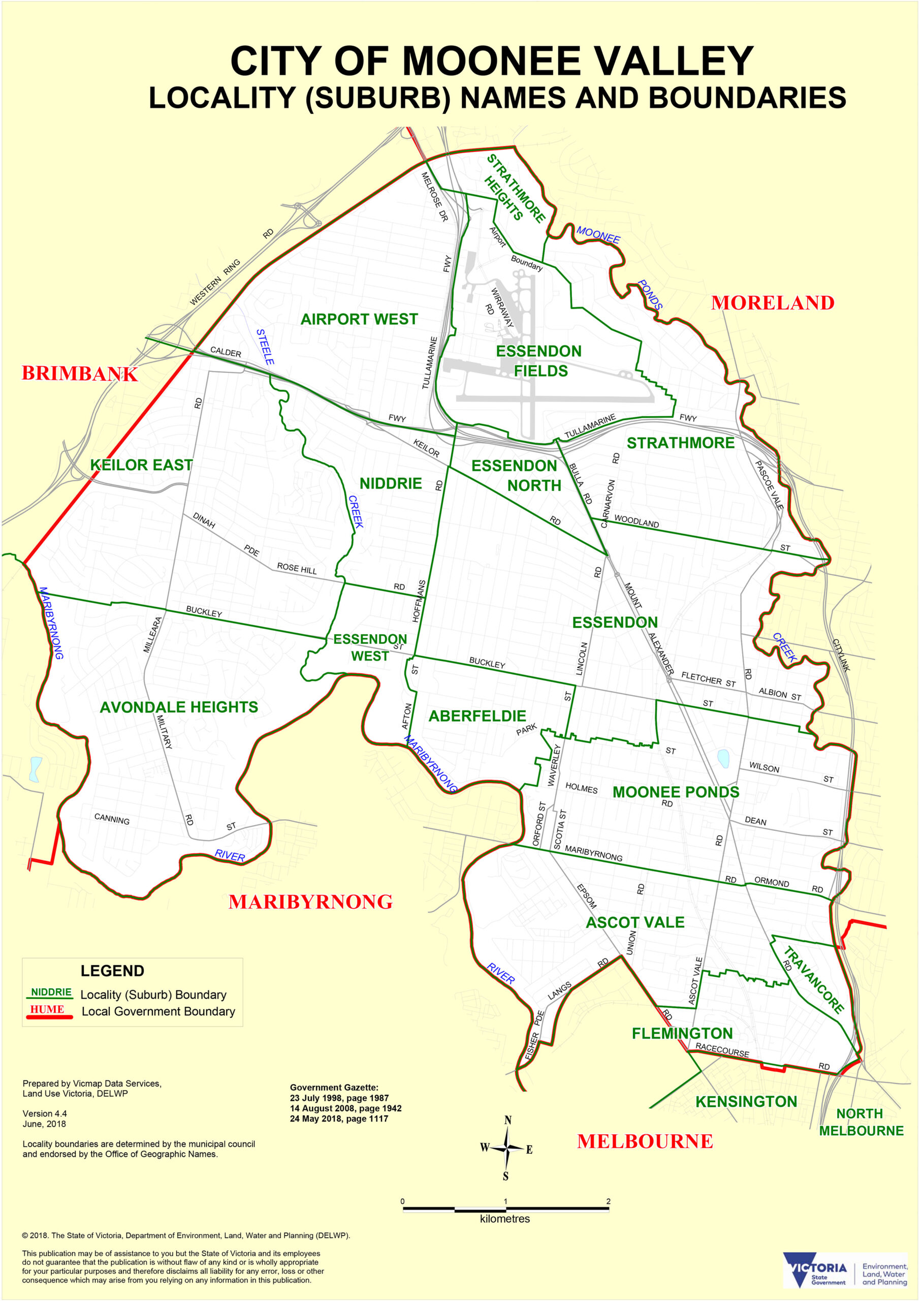
Moonee Valley was formed in December 1994 from the City of Essendon and part of the City of Keilor, covering 43 square kilometres of the north-western suburbs between 7 and 15 kilometres from the CBD. The population reached 129,732 in June 2024. The area sits on Wurundjeri-woi-worrung Country, with European settlement beginning in the 1830s. The Gold Rush through the 1850s transformed the Mount Alexander Road corridor, creating the commercial towns at Flemington, Moonee Ponds and Essendon that retain much of their Victorian-era streetscape today. Two things define Moonee Valley’s contemporary identity above all: the Cox Plate (run at Moonee Valley Racecourse since 1883) and the Essendon Football Club, one of the AFL’s most storied clubs with 16 premierships to its name.
Moonee Ponds
Moonee Ponds sits 7 kilometres north-west of the CBD. Puckle Street is its commercial heart: heritage facades dating to the 1890s, boutique fashion, al fresco cafes and restaurants that fill up on weekend mornings. The suburb carries a gentle cultural joke as the fictional hometown of Dame Edna Everage, though the real Moonee Ponds is considerably less outrageous and considerably more pleasant. Young professionals, established families and downsizers mix here, drawn by tram access along Mount Alexander Road and the street-level appeal of Puckle Street itself.
Essendon
Essendon is 8 kilometres north-west of the CBD and carries itself with the quiet confidence of a suburb that has never needed to prove anything. Broad, tree-lined streets and Federation-era homes define the streetscape. The Essendon Bombers football club was formed in the suburb in 1872 and the AFL identity runs deep in local life. Walk the Moonee Ponds Creek linear trail along the suburb’s eastern boundary for a surprisingly peaceful urban green corridor.
Essendon North
Essendon North extends the residential streetscape further toward Broadmeadows, with post-war housing mixed with newer development and more accessible price points than central Essendon. Keilor Road connects it to the retail and transport infrastructure of the broader precinct.
Essendon West
Essendon West runs from Hoffmans Road to the Maribyrnong River, with an elevated section offering views across the river valley. It is a quiet suburb, often overlooked in favour of its more prominent neighbours, which is exactly the reason some residents chose it. The river forms a natural western boundary and recreational draw.
Flemington
Flemington is synonymous, internationally, with one Tuesday in November. The racecourse has hosted the Melbourne Cup since 1861 and transforms the entire suburb on race days. Beyond the racing calendar, Flemington is a compact residential neighbourhood with good tram access to the CBD and a community that is relaxed about sharing its streets with 100,000 racegoers once a year.
Ascot Vale
Ascot Vale is 6 kilometres north of the CBD with a housing stock that reads like a Victorian-era pattern book: preserved Edwardian homes, interwar bungalows and modern apartments sharing the same streets without obvious friction. The Melbourne Showgrounds anchor the suburb and host the Royal Melbourne Show annually. Union Road is the local shopping strip for independent food stores and cafes.
Avondale Heights
Avondale Heights occupies the south-western tip of the LGA, above the Maribyrnong River. Predominantly 1960s brick-veneer homes on generous blocks attract families who want proximity to the city without the inner-suburb density. The riverside reserves along the eastern boundary are the suburb’s most enjoyable feature.
Keilor East
Keilor East spans multiple decades of development: 1950s weatherboards, 1970s and 1980s larger homes, 1990s estate builds and contemporary townhouses all sitting alongside each other. A practical, well-connected suburb with Calder Freeway access to the airport and the north-west.
Niddrie
Niddrie is 13 kilometres north-west of the CBD and well-regarded for the quality of its day-to-day life. The Niddrie Shopping Centre on Keilor Road is a genuine focal point: a broad mix of cafes, restaurants and specialty shops that serve the surrounding residential catchment. Families, couples and retirees coexist here with an ease that reflects a well-established suburb.
Strathmore
Strathmore is 11 kilometres north-west of the CBD, quiet, leafy and well-established. Moonee Ponds Creek forms part of its boundary, and the Tullamarine Freeway is close enough to be useful without being intrusive. Strathmore Station on the Craigieburn line provides direct city access.
Aberfeldie
Aberfeldie is a small, elevated suburb in west Essendon with a boutique feel: quiet streets, character homes and a handful of local cafes. Aberfeldie Park looks over the Maribyrnong River valley and offers a view of the city’s western fringe that feels genuinely removed from urban life. Head there at dusk for the full effect.
Airport West
Airport West is 12 kilometres north-west of the CBD, defined by its proximity to Essendon Airport and the associated light industrial and freight uses. For most visitors, the main draw is Essendon DFO, one of Melbourne’s major outlet shopping destinations with factory-direct pricing across fashion, homewares and electronics. Visit mid-week to avoid weekend queues.
Pascoe Vale South
Pascoe Vale South sits at the northern boundary of Moonee Valley, sharing characteristics with both the Essendon precinct and the northern Coburg suburbs. Affordable, quiet and well-connected by tram and bus to both Moonee Ponds and Coburg’s commercial strips.
City of Hobsons Bay
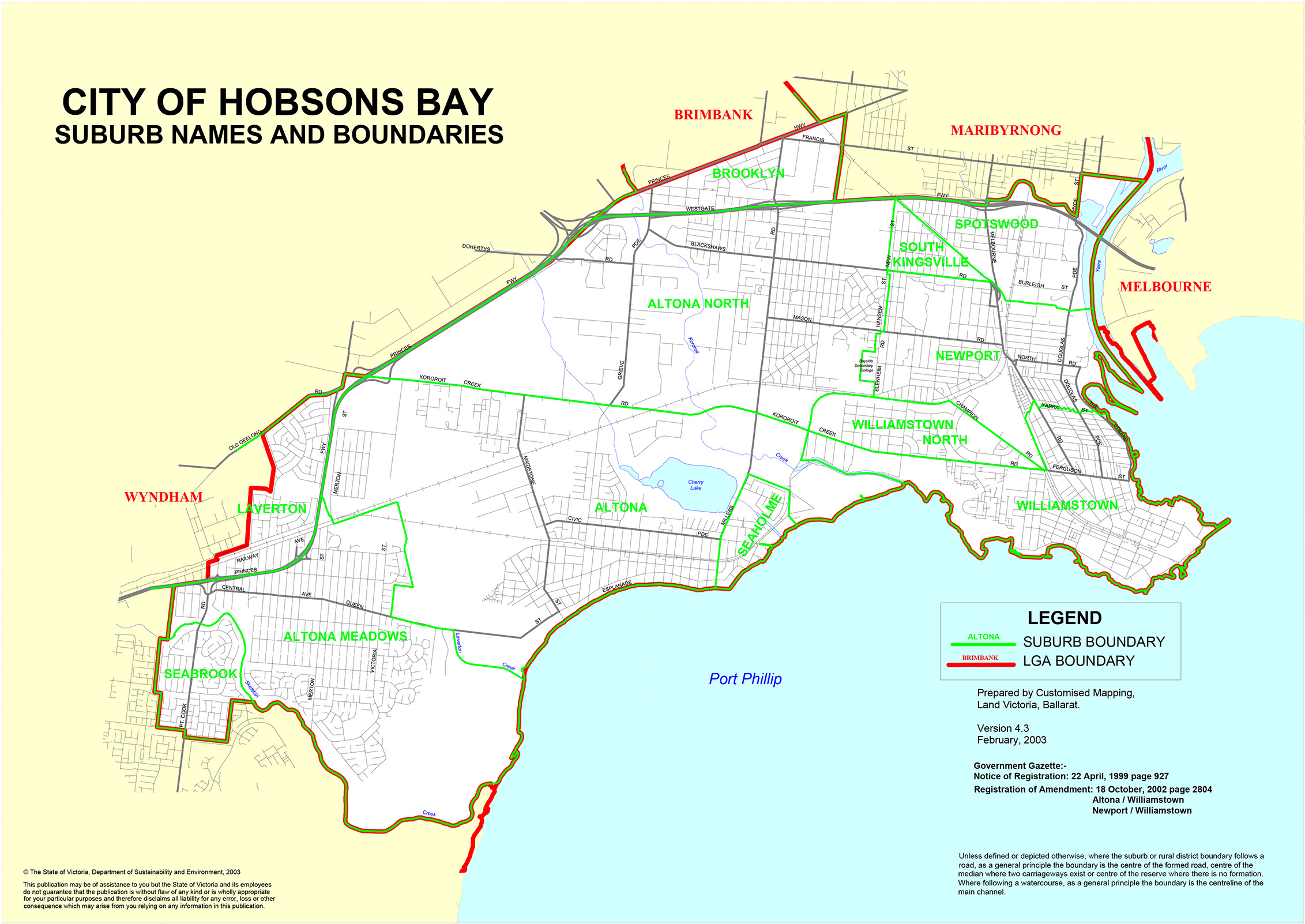
Hobsons Bay was founded in 1994 from the amalgamation of the City of Williamstown, the City of Altona and the suburb of South Kingsville. The LGA covers the south-western suburbs along Port Phillip Bay, 6 to 20 kilometres from the CBD, and takes its name from the bay named after Captain William Hobson. European settlement began in 1837 with the establishment of Melbourne’s original port at Williamstown, and maritime identity has never fully left the area. Each of the LGA’s distinct neighbourhoods retains its own personality, from the heritage port of Williamstown to the coastal family suburb of Altona, the arts enclave of Newport and the science-museum suburb of Spotswood.
Williamstown
Williamstown (Willy to everyone who lives there) is Melbourne’s oldest port settlement, established in 1837, and it wears its maritime heritage openly. HMAS Castlemaine, a World War II minesweeper, is permanently moored at Gem Pier as a museum ship. The Seaworks Maritime Precinct preserves Victoria’s seafaring history at a working deep-water port. The Timeball Tower dates to 1840, the Botanic Gardens to 1860. Victorian and gold rush-era architecture lines the main streets, and the annual Williamstown Literature Festival draws the country’s finest authors to the waterfront. Arrive by ferry from Docklands rather than by car: it is a far more enjoyable approach, and the views of the bay coming in are difficult to replicate from a car park.
Williamstown North
Williamstown North is a quieter, more residential extension of Williamstown proper, sharing the broader maritime precinct without the tourist traffic. Newport Lakes Regional Park provides excellent walking and wildlife spotting immediately to the north.
Altona
Altona faces west across Port Phillip Bay and offers Melbourne’s finest bay sunsets as a result. The beach is popular for swimming and the Pier Street strip provides cafes and a relaxed community atmosphere. Direct Werribee line access makes the CBD a straightforward 30-minute commute.
Altona Beach
Altona Beach is a small residential suburb positioned directly on the bay between Altona and Seaholme. The lifestyle is coastal and the streets are quiet. Cherry Lake reserve to the south provides a calmer water experience than the main beach when the crowds arrive on summer weekends.
Altona Meadows
Altona Meadows is an inland residential suburb developed from the 1970s, offering family-sized housing, good schools and solid infrastructure without the premium of the bay-facing suburbs. Bus connections link it to Laverton Station on the Werribee line.
Laverton
Laverton has a working-class heritage and ongoing regeneration underway. Laverton Station is a key Werribee line interchange. RAAF Base Williams borders the suburb, giving it an unusual dual identity of military and residential. The station is also a useful interchange for bus services reaching further west into Wyndham.
Newport
Newport has evolved from a major railway industry hub into a suburb that balances industrial heritage with genuine cultural energy. The Hall Street and Mason Street precincts offer boutique cafes, artisanal bakeries and heritage pubs. The Substation, a repurposed electric substation on Market Street, is a premier contemporary arts venue with year-round performances and exhibitions. The Newport Folk Festival and monthly artist markets bring the community together. Check the Substation’s program before you arrive.
Spotswood
Spotswood is 6 kilometres from the CBD and contains Melbourne’s most celebrated family cultural destination: Scienceworks. The hands-on science museum and its Planetarium occupy a site defined by the suburb’s industrial past, and the combination of period cottages, warehouse conversions and a strong community character makes Spotswood considerably more interesting to live in than its industrial reputation suggests. Book the Planetarium show in advance: it sells out on school holidays without exception.
South Kingsville
South Kingsville is a small, quiet residential suburb between Spotswood and Altona North, with post-war housing and a low-key community character. Newport and Spotswood supply the amenities and transport connections the suburb relies on.
Seaholme
Seaholme is one of Melbourne’s smallest suburbs: a compact bayside pocket between Altona and Altona Beach with attractive seaside streetscapes and a tight-knit community. Cherry Lake reserve and the coastal park are within easy walking distance, making Seaholme disproportionately pleasant for its modest size.
City of Brimbank
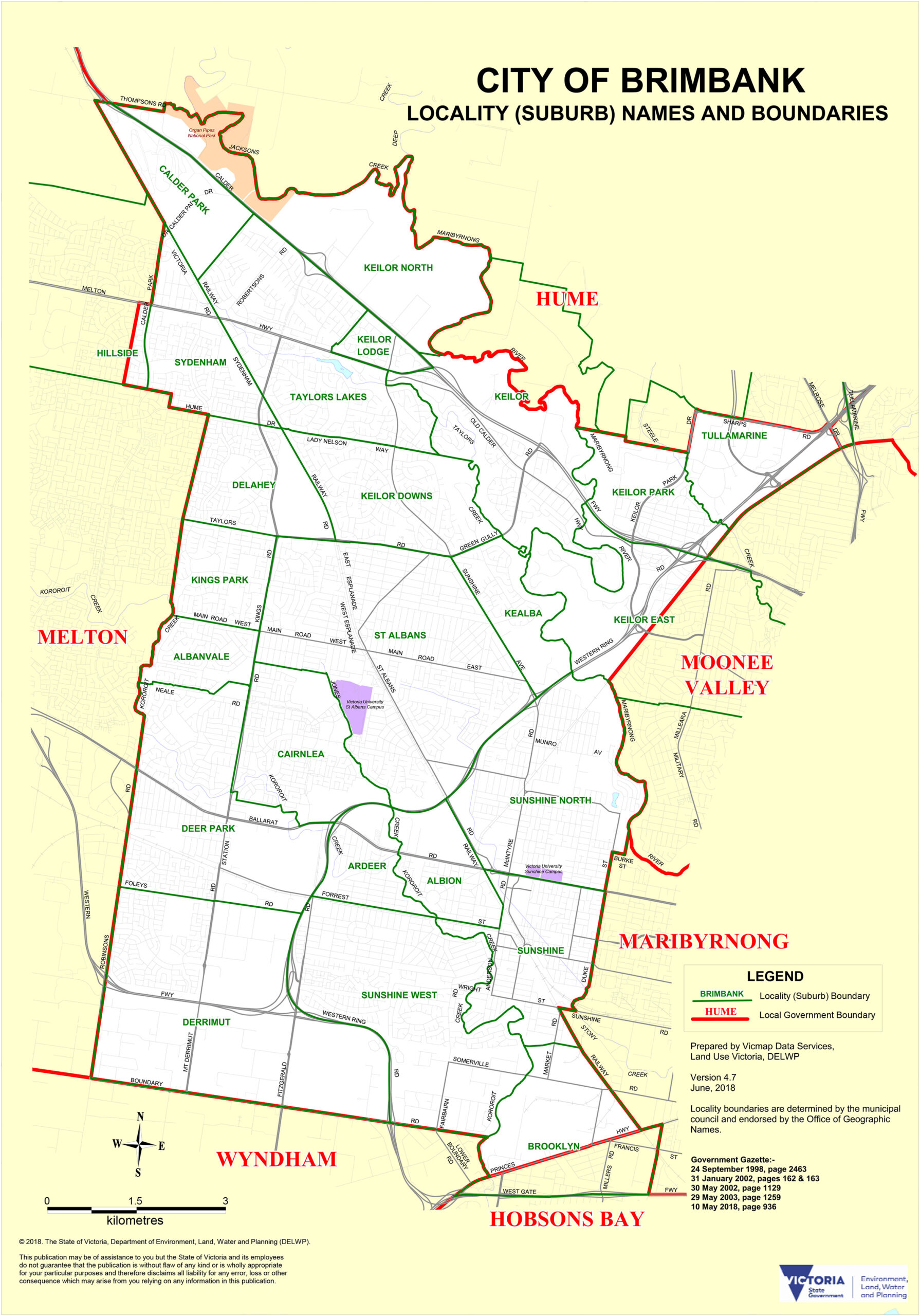
Brimbank was formed on 15 December 1994 from the western portions of the former Cities of Keilor and Sunshine, and is named after Brimbank Park in Keilor on the Maribyrnong River. With a population of 198,152 (2024), it is the sixth most populous municipality in Greater Melbourne and one of Australia’s most culturally diverse. Nearly half of residents were born overseas, and more than 160 languages are spoken across the LGA. Development after World War II drove rapid settlement from migrants originating in Yugoslavia, Malta and Italy, followed by Vietnamese, Sudanese and Burmese communities in subsequent decades. The five activity centres of Sunshine, St Albans, Deer Park, Sydenham and Keilor each serve their own catchment, and Sunshine is a major rail interchange where the Sunbury, Melton, Ballarat and Bendigo lines diverge.
Sunshine
Sunshine is 12 kilometres west of the CBD and a genuine cultural crossroads. Once anchored by the Sunshine Harvester Works (whose heritage-listed H.V. McKay Memorial Gardens survive from 1909), the industrial core has gradually given way to a multicultural food and retail scene along Hampshire Road. Vietnamese bakeries, African restaurants and Indian eateries operate side by side. A $143 million revamp of Hampshire Road has added contemporary walkways, cycle paths and green spaces to a street that did not previously invite lingering. As Melbourne’s western rail hub, Sunshine also has a practical utility that the inner city cannot match for those travelling outward.
St Albans
St Albans is 17 kilometres north-west of the CBD, established in 1887. Only 32.5 per cent of residents were born in Australia, a figure that tells you more about the suburb’s character than any architectural description could. Vietnamese and Eastern European heritage communities give St Albans its food identity. The St Albans Wildflower Garden on Main Road West is spectacular in spring (September through October) and consistently undervisited by anyone who does not live nearby.
Albion
Albion is a small suburb adjacent to Sunshine, with Albion Station serving as a key rail interchange on the Sunbury and Melton lines. The suburb’s character is a mix of light industrial and residential uses, shaped primarily by its role as a transport and logistics node.
Deer Park
Deer Park is 17 kilometres west of the CBD with Maltese, Italian, Vietnamese, Spanish and Macedonian communities giving it a multicultural texture. Deer Park Station on the Ballarat line is the transport anchor, and the suburb offers affordable family housing as an alternative to the more expensive inner-west suburbs.
Keilor
Keilor is the LGA’s historic northern anchor, officially laid out in 1850 as a gold rush stopover on the route to the diggings. The charming, tree-lined Keilor Village has retained much of that heritage character. Brimbank Park, on the Maribyrnong River and the park for which the entire LGA is named, offers extensive bushwalking that feels genuinely removed from urban Melbourne. It is one of the city’s underappreciated natural escapes.
Keilor Downs
Keilor Downs was developed from the 1970s and offers family-sized homes with good school options and proximity to Watergardens Town Centre, the region’s major retail hub. Watergardens Station on the Sunbury line provides direct CBD access.
Keilor Lodge
Keilor Lodge is a quiet residential suburb adjacent to Keilor Downs, settled primarily in the 1980s and 1990s. Good Calder Freeway access and proximity to Watergardens makes it a practical choice for families who want suburban space without sacrificing connectivity.
Kings Park
Kings Park is a quiet, residential suburb in Brimbank’s north-east, developed from the 1990s with family homes and a relaxed character. St Albans Station on the Sunbury line is the nearest rail access.
Ardeer
Ardeer carries a history tied to ICI (now Orica) explosives manufacturing on its western edge. The residential pockets are quiet and private, largely because the industrial land use to one side keeps the suburb off most people’s radar. That suits residents who chose it for exactly that reason.
Cairnlea
Cairnlea is a planned residential estate developed from the early 2000s on former industrial land. Generous open spaces, walking tracks and community facilities were built into the original design. A younger demographic and strong family focus define the suburb’s energy.
Sydenham
Sydenham sits at the outer edge of Brimbank’s north-west, straddling the boundary with Melton. Sydenham Station on the Sunbury line is its main infrastructure anchor, and recent residential growth has extended the suburb’s footprint into what was previously open land.
Taylors Lakes
Taylors Lakes is a leafy, family-oriented suburb developed from the 1990s with curvilinear streets, generous parks and a relaxed outer-suburban character. Watergardens Town Centre is a short drive or bus ride and provides the suburb’s main retail destination alongside cinema and dining options.
City of Wyndham
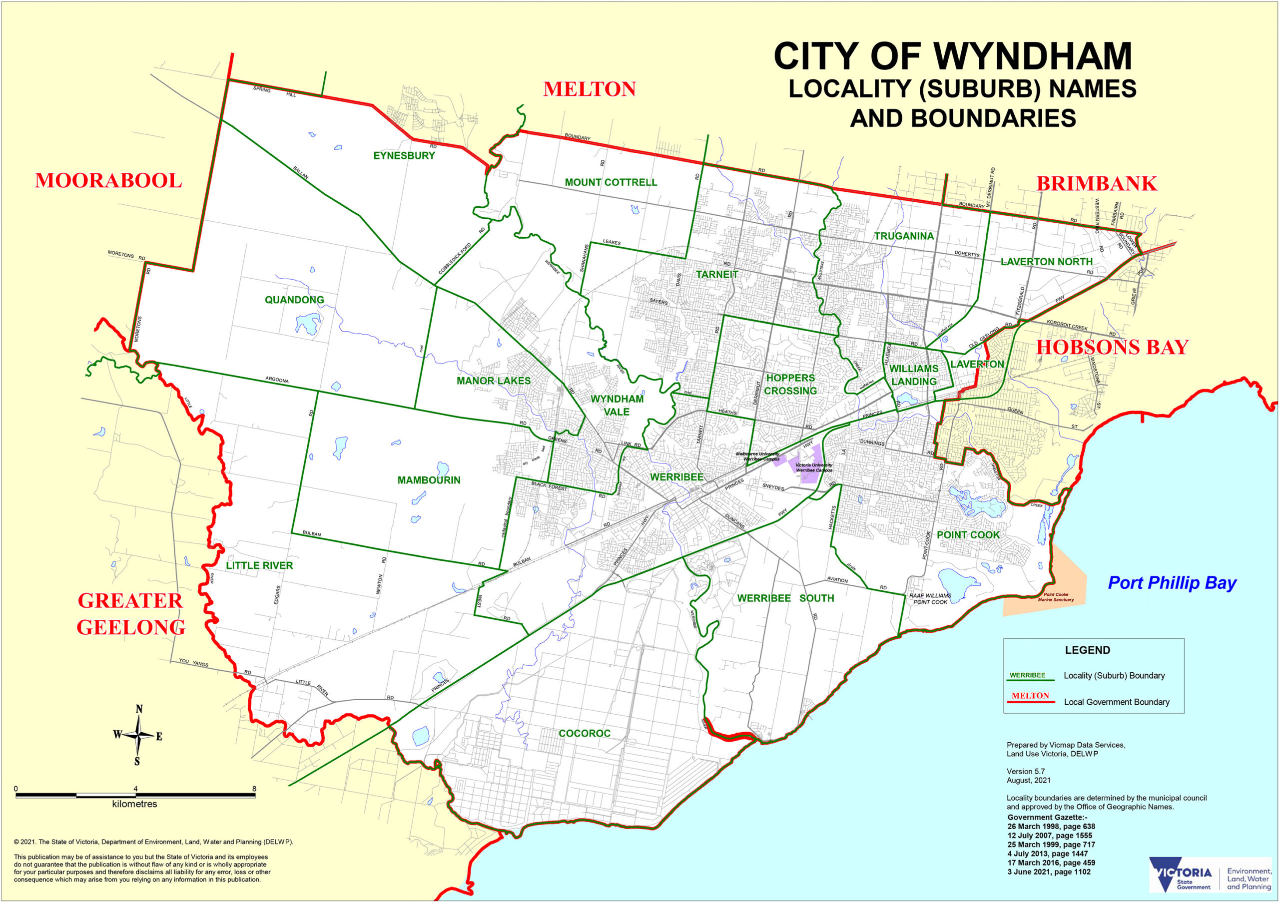
Wyndham covers 542 square kilometres of Melbourne’s outer south-western fringe and recorded a population of 292,011 at the 2021 census, with projections that put it past 500,000 by 2050. It is one of Victoria’s fastest-growing regions, and that growth is concentrated in Point Cook, Tarneit, Truganina and Wyndham Vale, where new housing estates arrive faster than maps can be updated. The area sits on Wadawurrung Country. European settlement began in the 1830s with pastoral expansion, and the landscape of the Werribee Plains remains visible beneath the new estates: wide skies, flat land and occasional remnant vegetation. The historic heart of the LGA is Werribee township, where the Chirnside brothers built their extraordinary pastoral estate in the 1870s and the state’s finest heritage zoo and rose garden now occupy the grounds.
Werribee
Werribee is 30 kilometres south-west of the CBD and carries the LGA’s heritage identity most visibly. The Werribee Park Mansion (60 rooms, Italianate-Renaissance Revival, built 1874 to 1877) is listed on the Victorian Heritage Register and now part of a precinct that includes the Victoria State Rose Garden (over 5,000 blooms), the K Road Cliffs and the Werribee Open Range Zoo. The zoo, on 225 hectares of African savannah-style landscape, is a genuine Melbourne day-trip highlight: rhinos, cheetahs, giraffes and zebras in open enclosures, plus a safari bus that requires advance booking on weekends. Book it.
Hoppers Crossing
Hoppers Crossing was Wyndham’s first major residential expansion, first subdivided in 1963 and developed through the 1970s and 1980s. It is now a well-established family suburb anchored by Pacific Werribee, one of the state’s largest suburban shopping centres with over 300 stores, cinemas and restaurants. Good Werribee line rail access makes the CBD manageable for daily commuters.
Wyndham Vale
Wyndham Vale is a rapidly growing suburb south of Hoppers Crossing, with new estates, schools and community facilities arriving in parallel with its expanding population. Wyndham Vale Station on the Werribee line opened as part of the Regional Rail Link, and the suburb’s median house price continues to attract first-home buyers priced out of closer-in suburbs.
Truganina
Truganina straddles the Wyndham and Melton boundary and is among Melbourne’s fastest-growing communities. New housing estates, parks and schools are being established alongside a diverse population including significant South Asian and East African communities. The Western Ring Road and Princes Freeway provide efficient access while public transport infrastructure catches up with the growth rate.
Tarneit
Tarneit is projected to exceed 56,000 residents by 2026. Tarneit Station connects directly to the CBD and park-and-ride facilities are available, though early arrival on weekday mornings is advisable. The suburb has the energy of a community assembling itself in real time: schools, sporting clubs, retail precincts and parks arriving as the population demands them.
Point Cook
Point Cook has grown from agricultural land into one of Melbourne’s most popular planned coastal communities since the late 1990s. It sits on Port Phillip Bay 23 kilometres south-west of the CBD, and Point Cook Coastal Park preserves a significant stretch of bay frontage for walking and birdwatching. RAAF Base Williams, at the suburb’s southern edge, is historically significant as the site of Australia’s first aerodrome. The combination of coastal access, planned infrastructure and proximity to the city has made Point Cook one of the west’s most sought-after family addresses.
Little River
Little River is a small rural township at the extreme south-western edge of Wyndham, on the boundary with Greater Geelong. The township is essentially unchanged from a century ago, with historic buildings and a wide, flat rural landscape that makes it feel genuinely remote. It is worth a brief detour on the Geelong road if you want to see Melbourne’s rural fringe in its least-developed form.
City of Melton
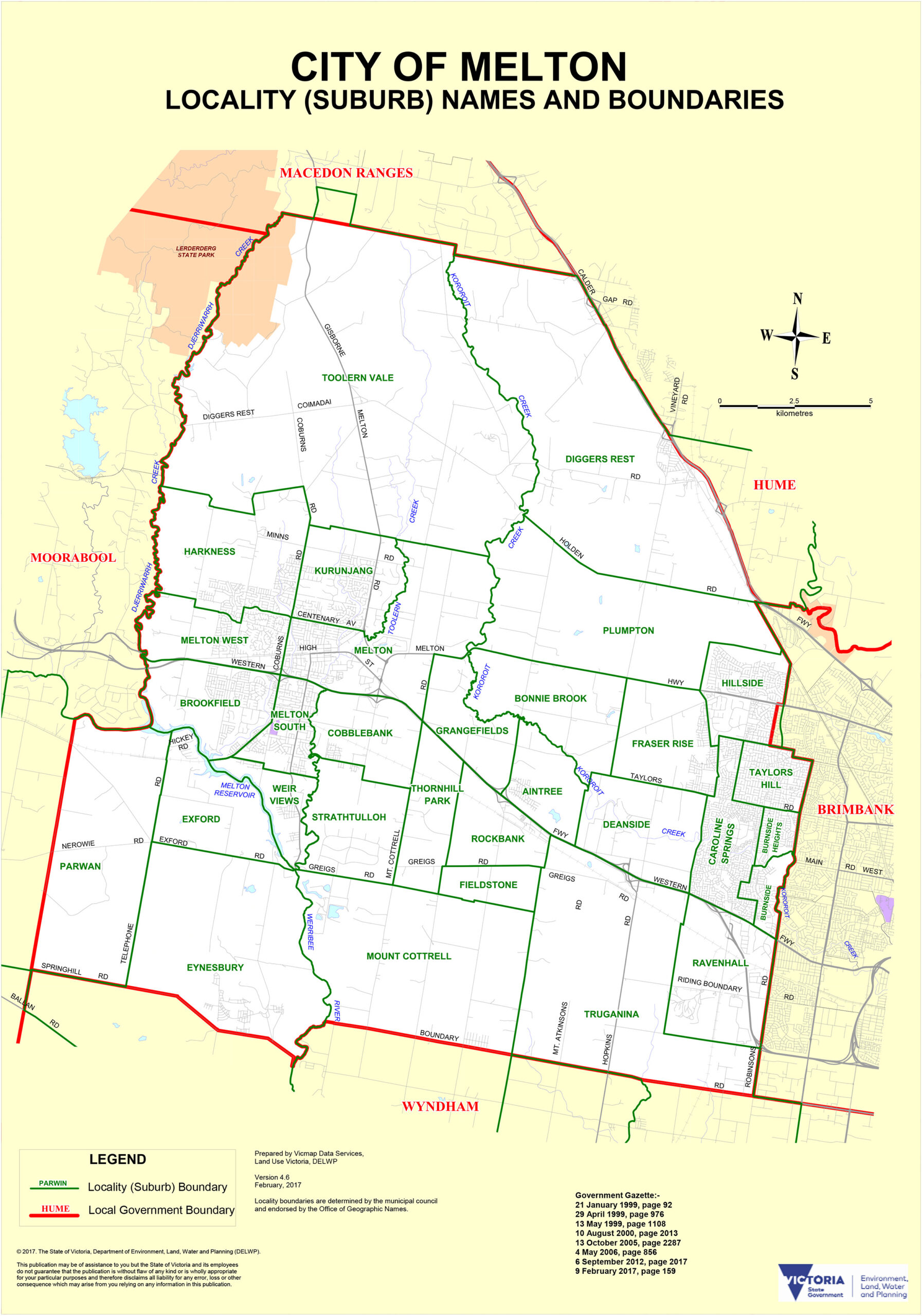
Melton is Melbourne’s most rapidly expanding municipality, sustaining annual population growth of 6.64 per cent in the year to June 2024. With over 30 suburbs and growth concentrated in the corridor between old Melton township and Caroline Springs, the LGA is building an entire city’s worth of community infrastructure at sustained speed. The Regional Rail Link, completed in 2015, was transformative: Melton Station now connects to Flinders Street in around 50 minutes, making the LGA viable for CBD workers who previously faced a bus-and-train journey of considerably longer duration. The area sits on the traditional Country of the Wurundjeri and Wathaurong peoples.
Melton
Melton township is the LGA’s historic and commercial centre, 35 kilometres west of the CBD. The original township character survives at its core, surrounded by expanding residential estates. Melton Station on the Regional Rail Link is the suburb’s most consequential recent addition, connecting residents to the city in a practical way for the first time. A working community with a genuine local identity built over decades of steady growth.
Melton South
Melton South has emerged as a residential focus in Melton’s east, with newer housing and improving amenity. Proximity to Caroline Springs and the Western Freeway corridor drives demand from families seeking value within commuting range of the CBD.
Melton West
Melton West is a well-established residential suburb to the west of the township, with affordable family housing and a strong local character. The Melton Valley Golf Course provides a major recreational facility for the area. It consistently offers some of the most affordable family housing within viable commuting distance of the CBD.
Caroline Springs
Caroline Springs is a masterplanned community 21 kilometres west of the CBD, developed from 1997 and now home to over 24,000 residents. Lake Caroline and CS Square shopping centre form the heart of the suburb: the lake walk is genuinely enjoyable and busy on weekends in a way that reflects a community that has taken to the amenity it was promised. Schools, a leisure centre, hotels, medical centres and parks were built into the plan from the outset, making Caroline Springs the most completely realised of Melton’s newer suburbs.
Hillside
Hillside is a residential suburb 24 kilometres north-west of the CBD, immediately west of Sydenham and developed primarily from the 1990s. Quiet family streets, good local schools and access to Sydenham Station on the Sunbury line give it a settled character that suits families who want proximity to Brimbank’s services without Brimbank’s density.
Rockbank
Rockbank is a small semi-rural hamlet at the edge of Melbourne’s urban growth boundary in Melton’s east. Rockbank Station on the Melton line is operational and the suburb is earmarked for significant growth, with projections of 22,000 future residents as the urban boundary extends westward. For now, it retains wide skies and a rural fringe character that will not last indefinitely. Enjoy it while it does.
Kurunjang
Kurunjang is a residential suburb within Melton, named after the Kurunjang people (Wurundjeri), providing one of the few suburb names in the growth corridor that explicitly acknowledges the traditional custodians of the land. A quiet residential suburb with Melton’s core services nearby and a cultural note worth knowing when exploring the area.
Frequently Asked Questions
What is Melbourne’s Western Region?
Melbourne’s Western Region refers to the six local government areas directly west of the CBD: City of Maribyrnong, City of Moonee Valley, City of Hobsons Bay, City of Brimbank, City of Wyndham and City of Melton. Together they cover the suburbs from 5 kilometres west of the CBD all the way to the rural fringe near Geelong, and include some of the city’s oldest and newest communities.
Which western suburbs are closest to Melbourne’s CBD?
Footscray, Seddon and Yarraville (all in Maribyrnong) are among the closest, sitting 5 to 7 kilometres from the CBD with direct train access. Spotswood and Newport in Hobsons Bay are similarly close. Moonee Ponds and Ascot Vale in Moonee Valley are roughly 6 to 7 kilometres north-west.
What is the best suburb in Melbourne’s west for food and culture?
Footscray is the standout for food diversity, with Vietnamese, East African, Filipino and Italian communities all contributing to one of Melbourne’s most genuinely multicultural dining scenes. Yarraville Village is the pick for a more curated dining and cafe experience. Newport offers strong arts culture through The Substation.
Which western suburbs have beach access?
Hobsons Bay’s suburbs along Port Phillip Bay provide the most direct beach access: Williamstown, Altona, Altona Beach, Seaholme and Newport all sit along the bay. Point Cook in Wyndham also has bay frontage through the Point Cook Coastal Park.
How do I get to Williamstown from the CBD?
The Williamstown train line runs directly from Flinders Street Station and takes around 30 minutes. Alternatively, the Williamstown ferry operates from Docklands and is a considerably more enjoyable arrival. Check Public Transport Victoria for current timetables.
Which western suburbs are considered fast-growing?
The City of Melton is Australia’s fastest-growing municipality. Within Wyndham, Tarneit, Truganina, Wyndham Vale and Point Cook have all seen rapid expansion over the past decade. The growth is driven by affordable land, improving infrastructure and the Regional Rail Link connection to the CBD.
Is it worth visiting Werribee as a day trip from Melbourne?
Werribee makes an excellent day trip. The combination of Werribee Park Mansion (Victorian Heritage Register), the Werribee Open Range Zoo (225 hectares of African savannah habitat), the Victoria State Rose Garden and K Road Cliffs provides enough for a full day. Train access from the CBD via the Werribee line takes around 50 minutes.
What is the cultural diversity like in Melbourne’s western suburbs?
The west is the city’s most genuinely multicultural region. Brimbank has nearly half its population born overseas, with over 160 languages spoken. Footscray’s Vietnamese and East African communities are long-established. St Albans has one of the lowest Australia-born percentages of any Melbourne suburb. More recent growth suburbs in Wyndham and Melton are drawing significant South Asian and East African communities.
Which western suburb has the best heritage architecture?
Williamstown has the strongest concentration of colonial and Victorian-era heritage architecture, including buildings dating to the 1840s. Essendon and Moonee Ponds have excellent Federation-era residential streetscapes. Yarraville and Footscray retain substantial workers’ cottage stock from the late 19th century.
Are there good parks and nature experiences in Melbourne’s west?
Yes, and they are underrated. Brimbank Park on the Maribyrnong River in Keilor is excellent for bushwalking. The Maribyrnong River Trail runs through multiple suburbs. Organ Pipes National Park near Keilor features striking basalt rock formations. The Hobsons Bay Coastal Park and Jawbone Flora and Fauna Reserve provide coastal and wetland experiences. Werribee Open Range Zoo and Point Cook Coastal Park are major natural attractions further out.
The western suburbs reward curiosity. Come with an appetite in Footscray, a sense of history in Williamstown, patience for growth in Wyndham and Melton, and an openness to being surprised by what you find in the suburbs in between.
References
- DataVIC – https://www.data.vic.gov.au – map data
- Melton Council – https://www.melton.vic.gov.au – local information
- Land.VIC – https://www.land.vic.gov.au – map data
- Victorian Electoral Commission – https://www.vec.vic.gov.au – map data