
The north starts as a postcode and ends as a personality. From the inner-ring energy of Northcote and Brunswick, where every second building hosts a record store or a wine bar, through the mudbrick-and-bushland calm of Eltham, the multicultural sprawl of Coburg and Broadmeadows, and out to the half-built greenfield estates of Mernda and Wollert, Melbourne’s Northern Region is not one place. It is seven local government areas, dozens of distinct communities, and a landscape that shifts from terrace house to paddock within forty minutes on a train.
Here is your guide to all of it.
Melbourne Northern Region Map
Note: this map shows the Whittlesea electorate, whereas only the City of Whittlesea is inside metropolitan Melbourne’s boundary.
Northern Region Legend
City of Banyule: Rivers, Reputations, and Impressionist Ghosts
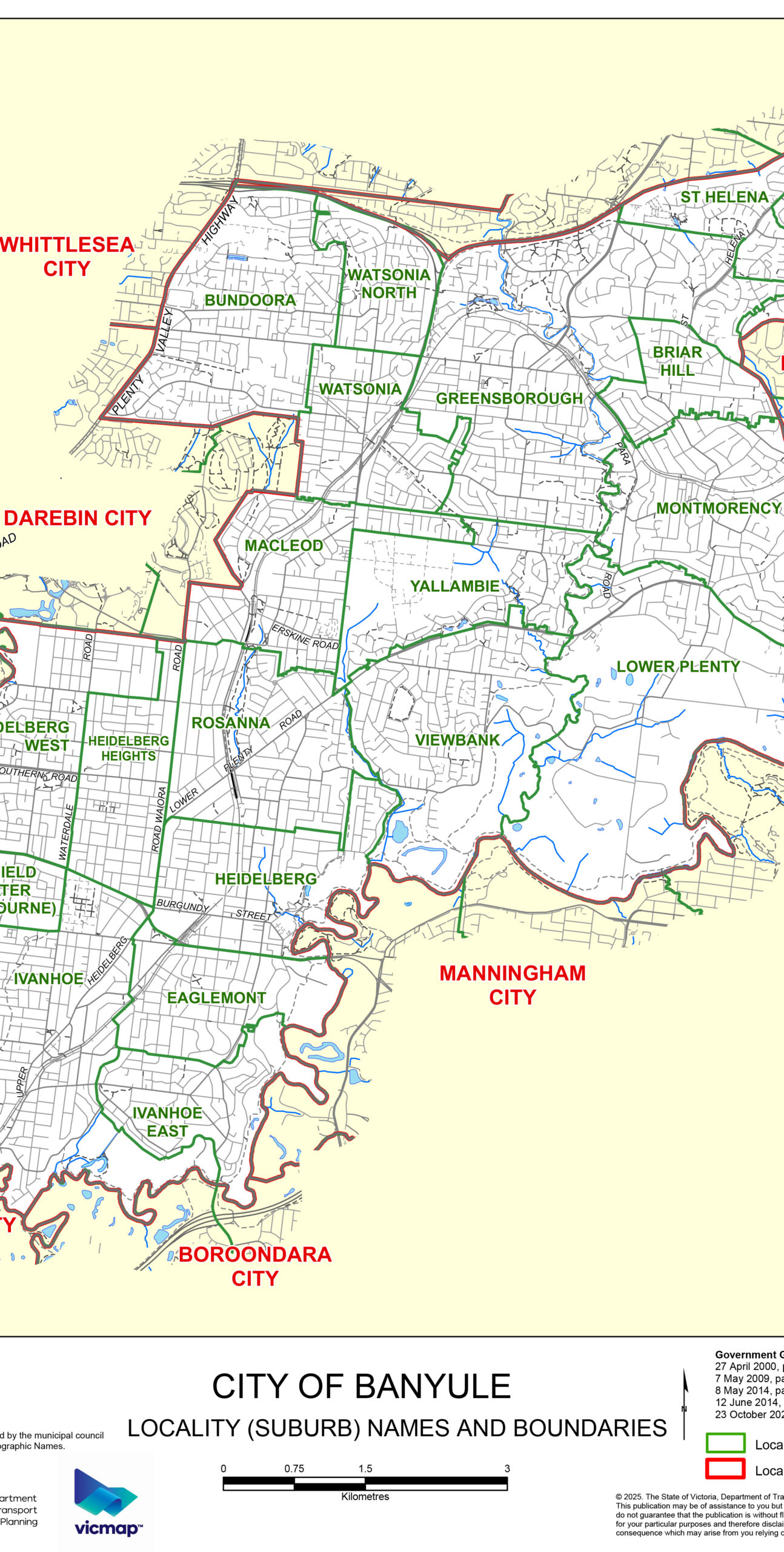
Banyule sits 7 to 21 kilometres north-east of the CBD, pinned between the Yarra River to the south and Darebin Creek to the west. With 63 square kilometres and a population of around 126,000, it is one of Melbourne’s more polished suburban councils: good schools, strong medical infrastructure, and a park system that would embarrass suburbs twice its size.
The suburb of Heidelberg carries the LGA’s most famous credential. In the 1880s, a group of painters including Tom Roberts, Arthur Streeton, Frederick McCubbin, and Charles Conder set up en plein air camps at Eaglemont, capturing Australian light with a directness that Melbourne’s conservative art world had never seen. They called their 1889 independent show the 9 by 5 Impression Exhibition (the canvases were painted on cedar cigar-box lids). Critics sneered; posterity disagreed. The Heidelberg School Artists Trail, a self-guided walk through key painting sites, follows this legacy today.
Heidelberg also hosts Melbourne’s most concentrated medical precinct: Austin Hospital, Mercy Hospital for Women, and Heidelberg Repatriation Hospital occupy a combined campus that draws patients from across the northern region and beyond. The Warringal Shopping Centre serves the precinct workers and residents alike.
Ivanhoe, 10 kilometres from the CBD, is Banyule’s most sought-after postcode. Heritage homes line avenues dropping toward the Yarra, the Upper Heidelberg Road strip pulls a reliable weekend brunch crowd, and Darebin Parklands (33 hectares, off-leash dogs welcome, free electric BBQs) fills on a Saturday like a village green. Come December, Ivanhoe’s Boulevard Christmas Lights draw visitors from across Melbourne for one of the city’s most earnest annual traditions.
Greensborough, 17 kilometres out and anchored by Greensborough Plaza’s 170-plus stores, is the north-east’s outer hub. The Hurstbridge rail line connects it to the city in under 35 minutes. Just south, the Plenty River flows through green corridors that cyclists and walkers claim on weekends.
Bundoora, straddling Banyule, Darebin, and Whittlesea council boundaries 15 kilometres from the CBD, is defined by education. La Trobe University’s Bundoora campus (267 hectares, the largest metropolitan university campus in Australia) and RMIT’s Bundoora West campus together bring tens of thousands of students and staff into what would otherwise be a quiet outer suburb. Bundoora Park’s 180 hectares include Mount Cooper, often cited as Melbourne’s highest suburban point.
| Suburb | Character | Distance from CBD |
|---|---|---|
| Heidelberg | Medical precinct, art history, civic centre | 14 km |
| Ivanhoe | Heritage homes, riverside parks, cafe strip | 10 km |
| Greensborough | North-east hub, regional shopping, rail terminus | 17 km |
| Bundoora | University suburb, large parklands | 15 km |
| Rosanna | Quiet village feel, wetlands access, rail | 13 km |
| Macleod | Family suburb, Yarra Flats access | 14 km |
| Watsonia | Residential, Hurstbridge rail | 17 km |
| Montmorency | Green Wedge fringe, semi-rural feel | 19 km |
| Briar Hill | Quiet residential, Plenty River access | 20 km |
| Bellfield | Compact, close to Darebin Creek parklands | 11 km |
| Viewbank | Established family suburb, Banyule parklands | 16 km |
Getting there: The Hurstbridge rail line connects Ivanhoe, Heidelberg, Rosanna, Macleod, Watsonia, Greensborough, Montmorency, and Briar Hill to the city. Ring Road provides freeway access.
City of Darebin: The World’s Coolest Street (It’s Not Hype)
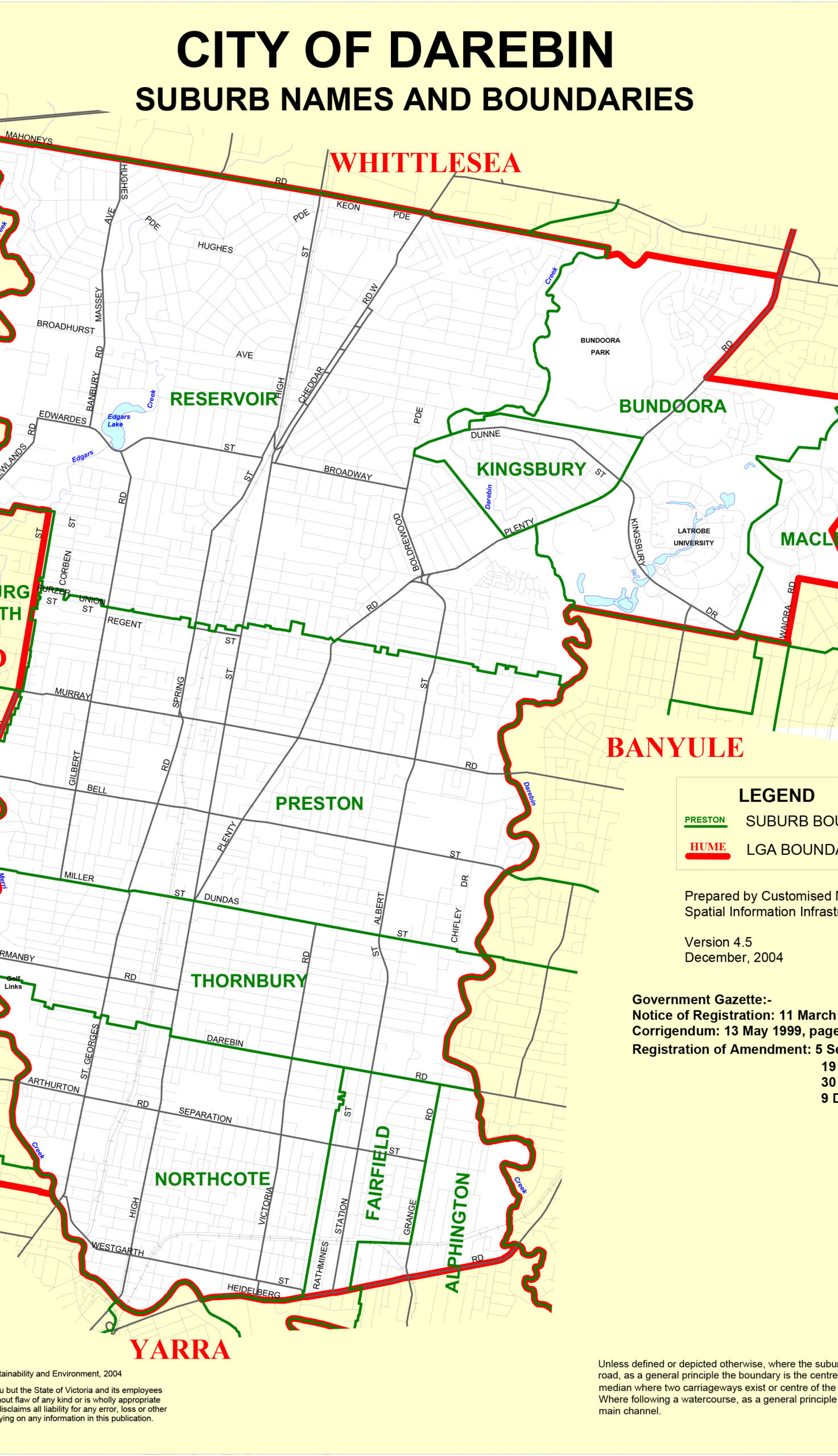
Darebin is 5 to 15 kilometres north of the CBD and contains approximately 163,000 people, more than 118 spoken languages, and one of the most culturally layered suburban councils in the country. It also has High Street.
High Street runs the length of the municipality, from Westgarth in the south through Northcote and Thornbury to Preston in the north. In 2024, Time Out magazine voted it the World’s Coolest Street. The ranking surprised no one who lives here and confused everyone who thought that title still belonged to somewhere in Tokyo or Brooklyn.
Northcote, 6 kilometres from the CBD, is the inner-north’s most complete suburb for eating, drinking, and live music. The Northcote Social Club and Croxton Band Room anchor Melbourne’s independent music circuit. Bar Nonno pours biodynamic wine in an atmosphere that makes you feel you stumbled into someone’s very well-curated living room. Wesley Anne, a former church converted to a pub, has a back garden strung with lights where bands play on weekends. Scott Pickett’s hatted restaurant Estelle has been refining its tasting menu here for years. The Westgarth Cinema, a single-screen institution, still runs festival films and Sunday-morning sessions for people who haven’t quite recovered from Saturday night.
Thornbury, immediately north, is Northcote’s less-expensive sibling. Italian pasticcerias share High Street pavement with burger joints and South American restaurants. The vibe is unpretentious in a way Northcote stopped being sometime around 2015.
Preston, 9 kilometres from the CBD, is Darebin’s most demographically complex suburb: 45-plus per cent of residents born overseas, with strong Italian, Greek, Vietnamese, Lebanese, and growing Indian and East African communities. Preston Market (250-plus stalls, 80,000 visitors per week) has operated since 1970 and remains Melbourne’s second-largest public market. Arrive on a Saturday morning and work through the delis, fishmongers, Middle Eastern pastry counters, and fresh produce stalls before the crowds hit full density by 10am.
Reservoir, 11 kilometres out, is where Darebin’s gentrification wave is currently breaking. Established Italian and Greek communities are joined by South Asian and East African arrivals. Edwardes Lake Park is the suburb’s green anchor. The rail corridor (two stations on the Mernda line) makes it accessible enough that buyers priced out of Preston are looking hard at Reservoir.
Fairfield and Alphington sit river-adjacent at Darebin’s southern edge. Alphington Paper Mill, a 17-hectare former industrial site, is Melbourne’s largest urban renewal project in the inner north. When complete, it will deliver thousands of dwellings, retail, and community facilities within walking distance of the Yarra.
| Suburb | Character | Distance from CBD |
|---|---|---|
| Northcote | Inner-north heartland, live music, wine bars, hats | 6 km |
| Thornbury | Affordable High Street, casual dining, local character | 7 km |
| Preston | Multicultural market hub, High Street north, diverse food | 9 km |
| Reservoir | Established, affordable, growing cafe scene | 11 km |
| Fairfield | Darebin Creek parklands, quiet and sought-after | 7 km |
| Alphington | Yarra River edge, major urban renewal site | 7 km |
| Heidelberg West | Diverse, improving, Darebin Creek access | 11 km |
| Kingsbury | Residential, La Trobe University adjacent | 13 km |
Getting there: Mernda rail line (Northcote, Thornbury, Preston, Reservoir). Tram 86 runs along High Street. Strong cycling infrastructure via Merri Creek Trail and the Capital City Trail connection.
City of Merri-bek: Rocky Country, Rebranded
In September 2022, the City of Moreland became the City of Merri-bek. The previous name had carried an uncomfortable weight: ‘Moreland’ traced back to a Jamaican slave plantation. After community consultation, 59 per cent of the 6,315 respondents voted for Merri-bek, the Woi-wurrung word for ‘rocky country’. The change was gazetted 13 September 2022. The basalt plains that give the name its meaning are still underfoot every time you walk Sydney Road.
Merri-bek covers Melbourne’s inner-north west, 4 to 11 kilometres from the CBD. Its northern anchor is Brunswick; its southern reach is Coburg. Then come Pascoe Vale, Glenroy, Fawkner, and Hadfield as the LGA stretches toward Hume’s boundary.
Brunswick is Melbourne’s bohemian postcode-in-chief. Sydney Road is the three-kilometre spine: Lebanese bakeries, Turkish restaurants, Italian pasticcerias, record stores, vintage furniture, specialist coffee, and bars that double as art spaces. The Brunswick Ballroom hosts everyone from touring international bands to local improvisers. Merri Creek Trail runs along the eastern edge, offering a bush-feeling corridor that is technically still less than 6 kilometres from the CBD.
Coburg, 8 kilometres north, has a history that is colourful in the old sense of the word. Pentridge Prison operated here from 1850 (prisoners initially quarried bluestone for Melbourne’s roads) until its closure in 1997. The suburb was renamed from its original moniker in 1870 by residents who felt stigmatised by the gaol association, choosing ‘Coburg’ after the royal house of Saxe-Coburg ahead of the Duke of Edinburgh’s impending colonial visit. Today, Pentridge is a heritage-listed residential and retail precinct. The Boot Factory cafe occupies the former prison workshop. And Coburg’s stretch of Sydney Road is now so strongly associated with kebab culture that the Herald Sun readers poll named it Melbourne’s unofficial kebab capital (the affectionate local shorthand is ‘Kebaburg’). Half of Coburg’s residents were born overseas; nearly every major Middle Eastern cuisine is within easy walking distance of the tram stop.
Pascoe Vale, 9 kilometres from the CBD, is quieter and more family-oriented. Named after John Pascoe Fawkner’s original ‘Pascoeville’ property, it has a good parks network (Cole Reserve, Austin Reserve, Gavin Park) and a growing cafe culture along Pascoe Vale Road. Glenroy, a little further north, is seeing an influx of first-buyers and new cafes, while Fawkner, 12 kilometres out, retains its honest working-class identity alongside growing South Asian and Italian communities.
| Suburb | Character | Distance from CBD |
|---|---|---|
| Brunswick | Sydney Road dining, live music, arts scene | 5 km |
| Brunswick East | Lygon Street extension, quieter residential | 5 km |
| Brunswick West | Merri Creek access, community-focused | 6 km |
| Coburg | Multicultural, prison heritage, kebab capital | 8 km |
| Coburg North | Quieter, growing cafe scene, Moonee Ponds Creek | 10 km |
| Oak Park | Family suburb, leisure centre, outdoor pool | 10 km |
| Pascoe Vale | Family-oriented, parks, rail access | 9 km |
| Glenroy | Affordable, multicultural, improving | 12 km |
| Fawkner | Working-class, Italian and South Asian community | 12 km |
| Hadfield | Compact residential, Hadfield Ponds Reserve | 13 km |
Getting there: Upfield rail line serves Brunswick, Coburg, Glenroy, and Fawkner. Tram routes run along Sydney Road (tram 19) and Lygon Street. Upfield Path cycling corridor is one of Melbourne’s best dedicated off-road routes.
Nillumbik Shire: 91 Per Cent Green Wedge and Proud of It

Nillumbik calls itself the Green Wedge Shire, and the statistic backs the claim: 91 per cent of its 432 square kilometres is protected non-urban land. The planning controls are deliberate and defended. There will be no subdivision of the paddocks and ridgelines that press up against Eltham and Diamond Creek. The steep hillsides, hobby farms, and Kinglake National Park buffer will stay intact. This is the policy choice that makes Nillumbik the most ecologically intentional local government area in metropolitan Melbourne.
The urban nodes are small. Eltham, 20 kilometres north-east of the CBD, is the shire’s largest town and its artistic and commercial centre. The suburb’s identity as a creative community dates back decades: Justus Jorgensen began building Montsalvat in 1934 on a 5-hectare site above Eltham. Using mudbrick, rammed earth, and materials salvaged from demolished Melbourne buildings (the Great Hall has gothic balconies from the Royal Insurance Building), Jorgensen created Australia’s oldest continuously operating artists’ colony. It is still active: studios, galleries, concert venues, and gardens across a complex that looks, from the right angle, like a medieval Burgundian village relocated to the Australian bush. Exhibitions and concerts run year-round. The mudbrick building tradition Jorgensen pioneered went on to define Eltham’s residential character. You can still find mudbrick houses on Eltham’s hill streets today.
Diamond Creek, 23 kilometres north-east, is Nillumbik’s second centre: a solid township where the suburbs officially end and the country begins. The Diamond Creek Trail is a gently graded cyclist and pedestrian path winding through parkland and creek corridor. Edendale Community Environment Farm, beside the trail, runs open days where visitors meet chickens, alpacas, goats, and native animals on a working 7-hectare farm. A growing restaurant scene is developing along the main strip.
Hurstbridge, at the end of the metropolitan rail line (28 kilometres from the CBD), has built a food reputation out of all proportion to its size. Greasy Zoe’s is a two-hat restaurant serving a daily-changing set menu built entirely around hyper-local Nillumbik produce. The fact that a hatted, produce-obsessed restaurant operates at the terminus of a train line, in a town most Melburnians consider the far outback of the metro area, is exactly the kind of thing that makes the northern region interesting.
Panton Hill and Research are scattered rural localities with small family wineries. Panton Hill Winery, run by a Dutch owner, brings a distinctly European approach to Australian shiraz and pinot. Nillumbik Estate produces award-winning wines on the Yarra Valley fringe.
| Suburb/Locality | Character | Distance from CBD |
|---|---|---|
| Eltham | Artists’ colony, mudbrick heritage, creative community | 20 km |
| Diamond Creek | Township edge, creek trail, farm attraction | 23 km |
| Hurstbridge | Rail terminus, two-hat restaurant, bush pub | 28 km |
| Research | Rural acreage, small wineries | 25 km |
| Panton Hill | Hobby farms, winery, bushland | 28 km |
| Plenty | Gorge parklands, rural lifestyle | 23 km |
| Yarrambat | Rural, golf course, Plenty Gorge access | 25 km |
Getting there: Hurstbridge rail line serves Eltham, Diamond Creek, and Hurstbridge. East Ring Road (EastLink) provides freeway access from the south. Beyond the rail corridor, a car is essential.
City of Whittlesea: The Plenty Valley Grows Up
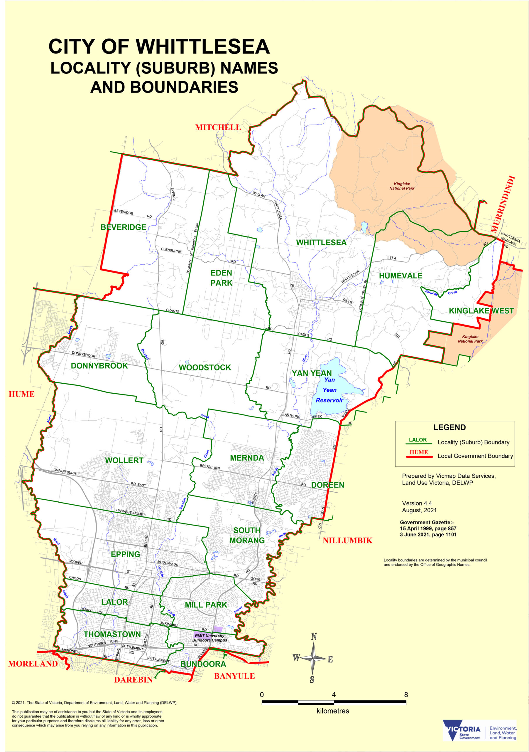
Whittlesea is one of Victoria’s fastest-growing municipalities: 490 square kilometres, a 2023 population of 245,000, and a growth rate that shows no sign of slowing. The LGA stretches from established middle suburbs like Thomastown and Lalor (16 to 17 kilometres from the CBD) through the booming Plenty Valley corridor (Mernda, Doreen, South Morang) and out to the almost-rural Whittlesea township. The common thread is family households in search of space, schools, and value.
Epping, 20 kilometres north, is Whittlesea’s commercial and health hub. Pacific Epping and Epping Plaza shopping centres anchor a retail precinct that serves the entire northern corridor. The Northern Hospital, an adjacent major public acute-care facility with emergency and maternity services, is one of the fastest-growing hospital campuses in the state.
South Morang and Mill Park occupy the inner Plenty Valley. Mill Park grew from 1,316 residents in 2001 to over 23,000 by 2021 and is still expanding. The Plenty River Trail winds through both suburbs, connecting walkers and cyclists to the broader Quarry Hills and Plenty Gorge park networks.
Mernda, 30 kilometres from the CBD, completed its transformation from semi-rural to growth suburb when the Mernda rail extension opened in 2018. The Laurimar estate (2,500 lots across 334 hectares) is the centrepiece: integrated parks, oval reserves, a community activity centre, and a semi-rural aesthetic that holds, just barely, against the pace of construction around it.
Doreen, east of Mernda on the Plenty River, has Plenty Gorge Parklands on its doorstep. With a population pushing 30,000 and climbing, Doreen is essentially a new town that did not exist twenty years ago. Wollert, 26 kilometres north, is newer still: 24,000 residents in 2021 and growing rapidly, with school and retail infrastructure still catching up to the residential pace.
Thomastown and Lalor are Whittlesea’s established multicultural suburbs. Thomastown has one of the highest proportions of overseas-born residents in the LGA (49.9 per cent). Lalor has strong Italian, Indian, and Macedonian communities. Both serve as the cultural and social anchors for the LGA’s longer-established residents.
| Suburb | Character | Distance from CBD |
|---|---|---|
| Epping | Regional retail hub, major hospital, rail connection | 20 km |
| South Morang | Inner Plenty Valley, river trail, family suburb | 23 km |
| Mill Park | Established family suburb, Plenty Valley trails | 22 km |
| Mernda | Master-planned growth estate, rail, gorge access | 30 km |
| Doreen | Rapid growth, Plenty Gorge frontage, young families | 32 km |
| Lalor | Multicultural, Italian and Indian communities | 17 km |
| Thomastown | Industrial, high cultural diversity, rail | 16 km |
| Wollert | Brand-new suburb, fast growth, young families | 26 km |
Getting there: Mernda rail line (City Loop to Mernda via Thomastown, Epping, South Morang, Mernda). Hume Freeway runs the western boundary. Multiple bus routes serve outer suburbs not yet on the rail network.
City of Hume: Airport, History, and 160 Nationalities
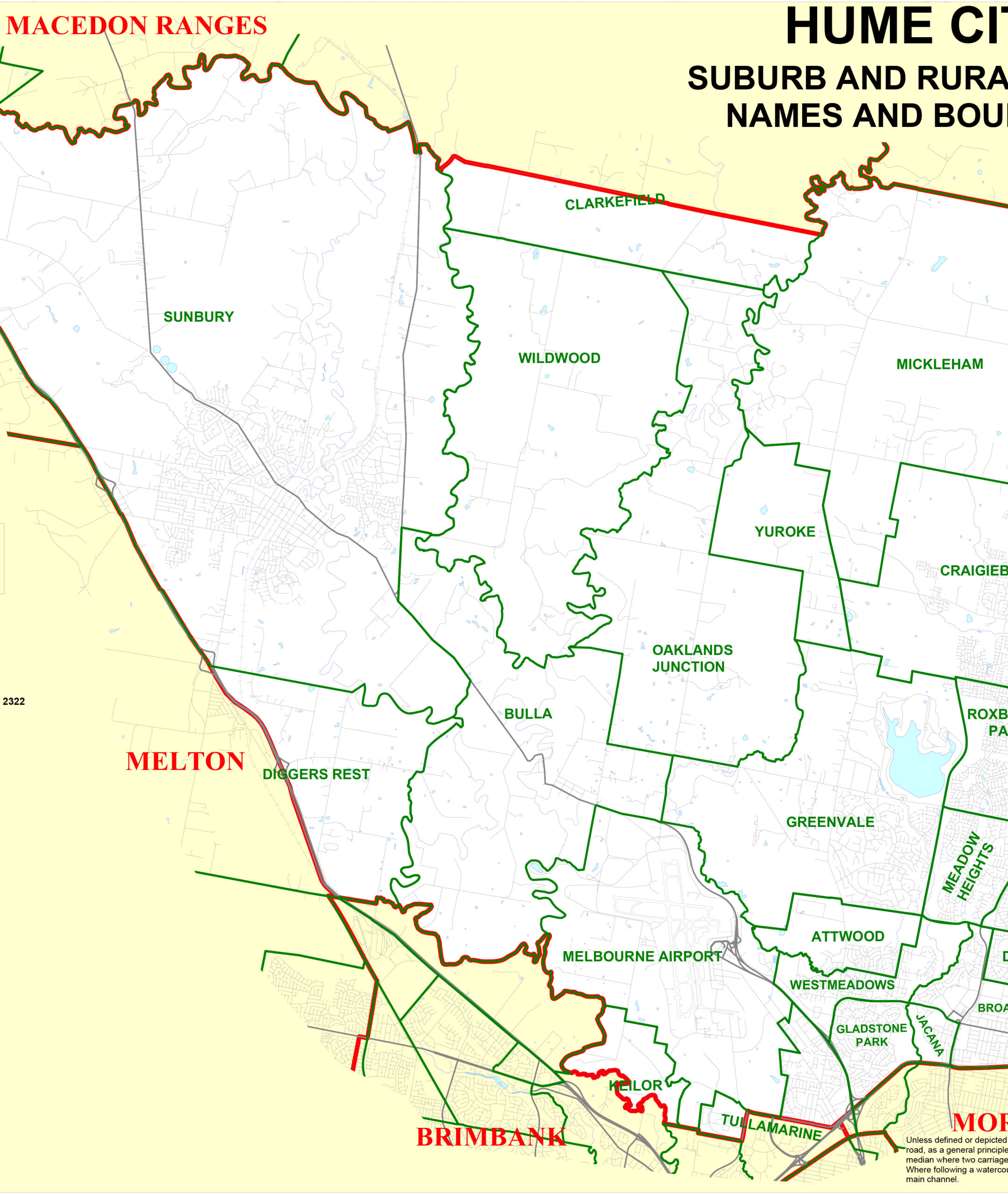
Hume is Melbourne’s north-western juggernaut: 504 square kilometres, 230,000 people, 160-plus nationalities, and the continent’s second-busiest airport. Formed in December 1994 from the former City of Broadmeadows, the Shire of Bulla, and parts of Keilor and Whittlesea, Hume spans from the dense inner suburbs of Broadmeadows (15 kilometres from the CBD) to the semi-rural township of Sunbury, 40 kilometres out.
Melbourne Airport, officially at Tullamarine, is the most tangible infrastructure fact in the LGA. It opened in 1970 (replacing Essendon Airport for international services) on 1,070 hectares of former Tullamarine farmland. In 2025 it served more than 36 million passengers across four terminals (one international, three domestic). The airport’s presence shapes everything in the western corridor of Hume: freight logistics, employment, and the ambient hum of jet engines audible from suburbs five kilometres away.
Broadmeadows, 15 kilometres north, is Hume’s civic heart and one of Melbourne’s most complex postwar social geographies. Postwar state housing estates placed large migrant and working-class communities in Broadmeadows from the 1950s onwards. The demographic mix today is striking: 43.5 per cent Australian-born, with Lebanese (8.8 per cent), Turkish (7.9 per cent), and Pakistani (3.7 per cent) communities among the largest overseas-born groups. Arabic and Turkish are the leading home languages after English. The food culture that comes with this density is exceptional: Middle Eastern bakeries, Turkish grills, Lebanese sweets, and halal butchers line the commercial strips.
Craigieburn, 30 kilometres north, is Hume’s growth story. Its population expanded from 50,000 in 2016 to approximately 70,000 in 2025, with more to come. The Craigieburn rail line terminates here (direct to City Loop). The award-winning Highlands Estate wraps around Highlands Lake, with 20-plus parks and 15 kilometres of walking and cycling trails woven through the development. Splash Aqua Park and Leisure Centre serves the recreational needs of a very young population (median age: 32).
Sunbury, 40 kilometres north-west, is a different proposition entirely. Named after Sunbury-on-Thames in Middlesex, the township was founded in 1857 and retains a genuine country-town character that newer Hume suburbs do not share. The Jacksons Hill site, a former Victorian-era asylum complex occupying an entire hillside, is now a heritage estate of converted buildings and open space. Wineries operate in the Sunbury wine region nearby. The V/Line and Metro rail connection means it is possible, if tiring, to commute from Sunbury to the CBD in under an hour.
| Suburb | Character | Distance from CBD |
|---|---|---|
| Broadmeadows | Civic hub, multicultural depth, postwar history | 15 km |
| Craigieburn | Growth estate, rail terminus, lakeside trails | 30 km |
| Sunbury | Country town heritage, wineries, rail access | 40 km |
| Tullamarine | Airport, aviation industry, logistics | 17 km |
| Gladstone Park | Family suburb, airport corridor | 17 km |
| Dallas | Affordable, diverse, established community | 18 km |
| Meadow Heights | Social housing mix, multicultural | 20 km |
| Roxburgh Park | Newer, family-oriented, good parks | 24 km |
| Greenvale | Leafy, lakes and wetlands, higher income | 22 km |
Getting there: Craigieburn rail line (City Loop to Craigieburn, via Coolaroo and Roxburgh Park). Sunbury line (V/Line and Metro services). Hume Freeway (M31) is the main road north. Tullamarine Freeway connects the airport precinct to the CBD. SkyBus operates from Melbourne Airport.
Mitchell Shire (Southern): Country Town, Commuter Price Tag
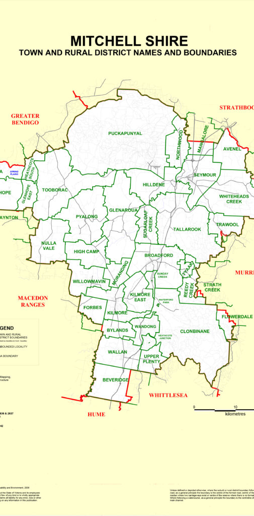
Strictly speaking, Mitchell Shire extends well into central Victoria: Seymour is its administrative hub, and Broadford, Kilmore, Tallarook, and many farming localities sit within its boundaries. But for Melbourne purposes, it is the southern fringe townships of Wallan and Kilmore that function as interface suburbs, drawing city commuters prepared to trade proximity for price and space.
Wallan, 40 kilometres north of the CBD, sits immediately beyond Hume’s urban boundary. The Hume Freeway off-ramp drops you straight to the main street. Wallan V/Line station on the Seymour line provides rail access to Southern Cross in around 50 minutes. The township has the feel of a suburb still deciding what it is: residential estates push out from a modest original town centre, and new schools and retail follow the rooftops. Young families dominate the demographic. Affordability is the lead selling point.
Kilmore, 65 kilometres north, is an older and more assured proposition. One of Victoria’s first inland towns, founded in the 1840s as a staging post on the Sydney Road, Kilmore has a 19th-century main street that has not been entirely rebuilt and not entirely forgotten. Kilmore Racecourse runs a calendar of meetings that brings people up from Melbourne. Kilmore International School is the town’s largest employer. For anyone who wants a genuine country address with a V/Line commute, Kilmore is worth a serious look.
| Town | Character | Distance from CBD |
|---|---|---|
| Wallan | Fast-growing interface township, families, V/Line access | 40 km |
| Kilmore | Historic country town, racecourse, international school | 65 km |
Getting there: V/Line Seymour line serves both Wallan and Kilmore with regular services to Southern Cross Station. Hume Freeway is the direct road connection. Allow 50 to 70 minutes to the CBD by rail.
Frequently Asked Questions
What is the Northern Region of Melbourne?
Melbourne’s Northern Region covers seven local government areas north of the CBD: the City of Banyule, City of Darebin, City of Merri-bek, Nillumbik Shire, City of Whittlesea, City of Hume, and the southern portion of Mitchell Shire. The region spans from inner suburbs 4 kilometres from the CBD to country towns more than 65 kilometres north, taking in everything from Northcote’s wine bars to Kilmore’s 19th-century main street.
Why was the City of Moreland renamed to Merri-bek?
The City of Moreland was renamed Merri-bek in September 2022 because ‘Moreland’ was linked to a Jamaican slave plantation. After a community consultation process, 59 per cent of 6,315 respondents chose the name ‘Merri-bek’, a Woi-wurrung word meaning ‘rocky country’, reflecting a reconciliation commitment to Traditional Owners of the land. The name change was gazetted 13 September 2022 and took effect 26 September 2022.
What is the Nillumbik Green Wedge?
The Nillumbik Green Wedge is a protected non-urban zone covering 91 per cent of Nillumbik Shire’s 432 square kilometres. Strict planning controls prevent subdivision and residential development across the area, preserving bushland, farmland, hobby farms, orchards, and small wineries as a wildlife and recreation buffer at Melbourne’s north-eastern edge. Kinglake National Park occupies the shire’s northern reaches.
Where is Melbourne Airport and which suburb is it in?
Melbourne Airport (IATA: MEL), also called Tullamarine Airport, is in Tullamarine within the City of Hume, approximately 23 kilometres north-west of the CBD. It opened in 1970, replacing Essendon Airport for international flights. The airport served more than 36 million passengers in 2025 and operates four terminals (one international, three domestic).
What is the Heidelberg School of Art?
The Heidelberg School was Australia’s first major art movement, centred on plein-air painting camps around Heidelberg and Eaglemont in the 1880s and 1890s. Key artists included Tom Roberts, Arthur Streeton, Frederick McCubbin, and Charles Conder. Their 1889 9 by 5 Impression Exhibition (named for the cigar-box-lid canvas size) is considered a milestone in Australian art history. A self-guided Artists Trail in Banyule follows key painting locations today.
What is Montsalvat in Eltham?
Montsalvat is Australia’s oldest continuously operating artists’ colony, founded in Eltham (Nillumbik Shire) in 1934 by architect and artist Justus Jorgensen. The 5-hectare estate was built using mudbrick, rammed earth, and materials salvaged from demolished Melbourne buildings. It includes medieval-inspired halls, studios, galleries, and gardens, and hosts regular exhibitions, concerts, and events throughout the year.
Which northern Melbourne suburb has the best food scene?
Two strips stand out. Sydney Road through Brunswick and Coburg (Merri-bek) concentrates Lebanese, Turkish, Italian, Egyptian, and Vietnamese dining across several kilometres of continuous streetfront. High Street through Northcote and Preston (Darebin) was voted the World’s Coolest Street by Time Out in 2024 and mixes hatted restaurants with multicultural street-food options and a dense bar and cafe scene.
How do I get to Melbourne’s northern suburbs by public transport?
Several rail lines serve the north: the Hurstbridge line (Banyule and Nillumbik), the Mernda line (Darebin and Whittlesea), the Craigieburn line (Merri-bek and Hume), and the Upfield line (Merri-bek). Trams run along High Street (route 86) and Sydney Road (route 19). V/Line Seymour services reach Wallan and Kilmore in Mitchell Shire.
What are the fastest-growing suburbs in Melbourne’s north?
Wollert, Donnybrook, Mernda, Doreen, and Craigieburn are among the fastest-growing suburbs in metropolitan Melbourne, all within the City of Whittlesea or City of Hume. Mitchell Shire’s southern towns of Wallan and Beveridge are also experiencing rapid growth. The entire northern corridor from Epping to Craigieburn is undergoing major infrastructure investment to keep pace with population demand.
What is the Preston Market?
Preston Market is a public marketplace in Preston (City of Darebin) that has operated since August 1970. With 250-plus stalls and around 80,000 visitors per week, it is Melbourne’s second-largest market. The market is known for its multicultural character, with fresh produce, international delis, Middle Eastern pastry counters, fishmongers, and specialty grocers representing the northern suburbs’ diverse communities.
References
- DataVIC – https://www.data.vic.gov.au – map data
- Land.VIC – https://www.land.vic.gov.au – map data
- Victorian Electoral Commission – https://www.vec.vic.gov.au – map data