
Start at Mentone’s bathing boxes on Port Phillip Bay and drive south. By the time you reach Portsea’s back beach on the tip of the Mornington Peninsula, you’ve crossed six local government areas, sampled two cultures of beach, eaten your way through one of Australia’s most concentrated food precincts, passed through a pair of the country’s fastest-growing suburbs, and stopped (if you were sensible) at a thermal mineral spring rising from 637 metres underground.
Melbourne’s Southern Region is a fusion of six distinct areas with their own personalities all stitched together by coastline, road and rail. Here’s how each one works.
Southern Region Map
Region Legend
City of Kingston: Melbourne’s Bayside Foreshore in Full
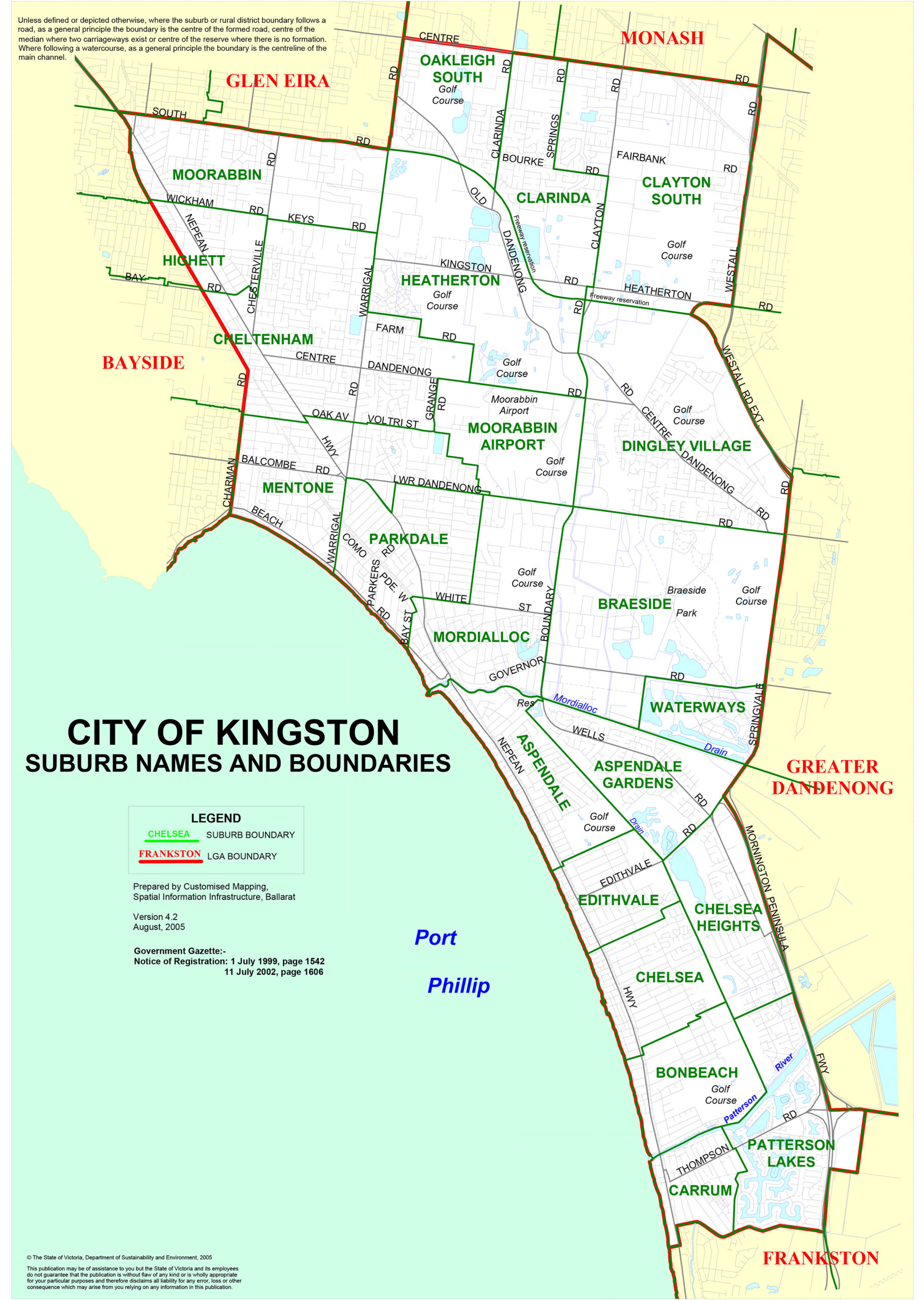
Kingston is where Melburnians discovered the beach. The 13 kilometres of continuous Port Phillip Bay coastline running from Mentone to Carrum is the LGA’s defining asset, its civic identity and its weekend draw all at once. This is bayside suburban living as Melbourne has refined it over 150 years: generous foreshore reserves, serious café culture, and the kind of community rhythms that make locals wonder why anyone bothers living further north.
The coastal suburbs run in a friendly chain. Mentone anchors the northern end with Beaumaris Bay, colourful Victorian bathing boxes and a village high street that punches well above its postcode. Parkdale and Mordialloc follow south, with Mordialloc offering the LGA’s most celebrated dining strip along Main Street, running parallel to the creek where Mordialloc Creek meets the bay. Aspendale, Edithvale, Chelsea, Bonbeach and Carrum take the coastline to the Kingston-Frankston boundary, each with its own foreshore character and its own loyal local swimming population.
| Suburb | Character | Distance from CBD |
|---|---|---|
| Moorabbin | Commercial and aviation hub; DFO outlet shopping; AFL heritage (St Kilda FC) | 17 km |
| Cheltenham | Affluent residential; strong café strip; Westfield Southland proximity | 20 km |
| Mentone | Heritage bathing boxes; Beaumaris Bay; village high street | 22 km |
| Mordialloc | Creek-mouth dining strip; foreshore reserve; Mordi Fest annual event | 24 km |
| Chelsea | Family-oriented bayside; calm swimming; relaxed local pace | 28 km |
| Aspendale | Quiet foreshore parkland; adjacent canal estate at Patterson Lakes | 27 km |
| Carrum | Patterson River mouth; boating; waterfront living at Patterson Lakes | 30 km |
| Heatherton | Inland; Kingston Heath Golf Club (one of Victoria’s most prestigious courses) | 20 km |
Braeside Park is the LGA’s most significant green space: a Parks Victoria-managed bushland reserve with wetlands, walking and cycling trails that feels considerably wilder than its suburban postcode suggests. Karkarook Park in Moorabbin is a constructed wetland and lake reserve good for an easy morning walk. Patterson River (and the canal estate of Patterson Lakes off the river mouth) offers calm-water kayaking, fishing and the pleasure of watching other people’s boats from the foreshore.
For shopping, DFO Moorabbin handles the outlet end and Westfield Southland in Highett covers everything else. The Mordi Fest is an annual outdoor music and food event at the Mordialloc foreshore that reliably delivers better vibes than its outer-suburban setting might suggest.
Getting there: The Frankston line runs the length of the coastal strip with stations at Cheltenham, Mentone, Mordialloc, Aspendale, Edithvale, Chelsea, Bonbeach and Carrum. Nepean Highway runs the inland edge.
City of Frankston: Gateway City With a Beach to Match
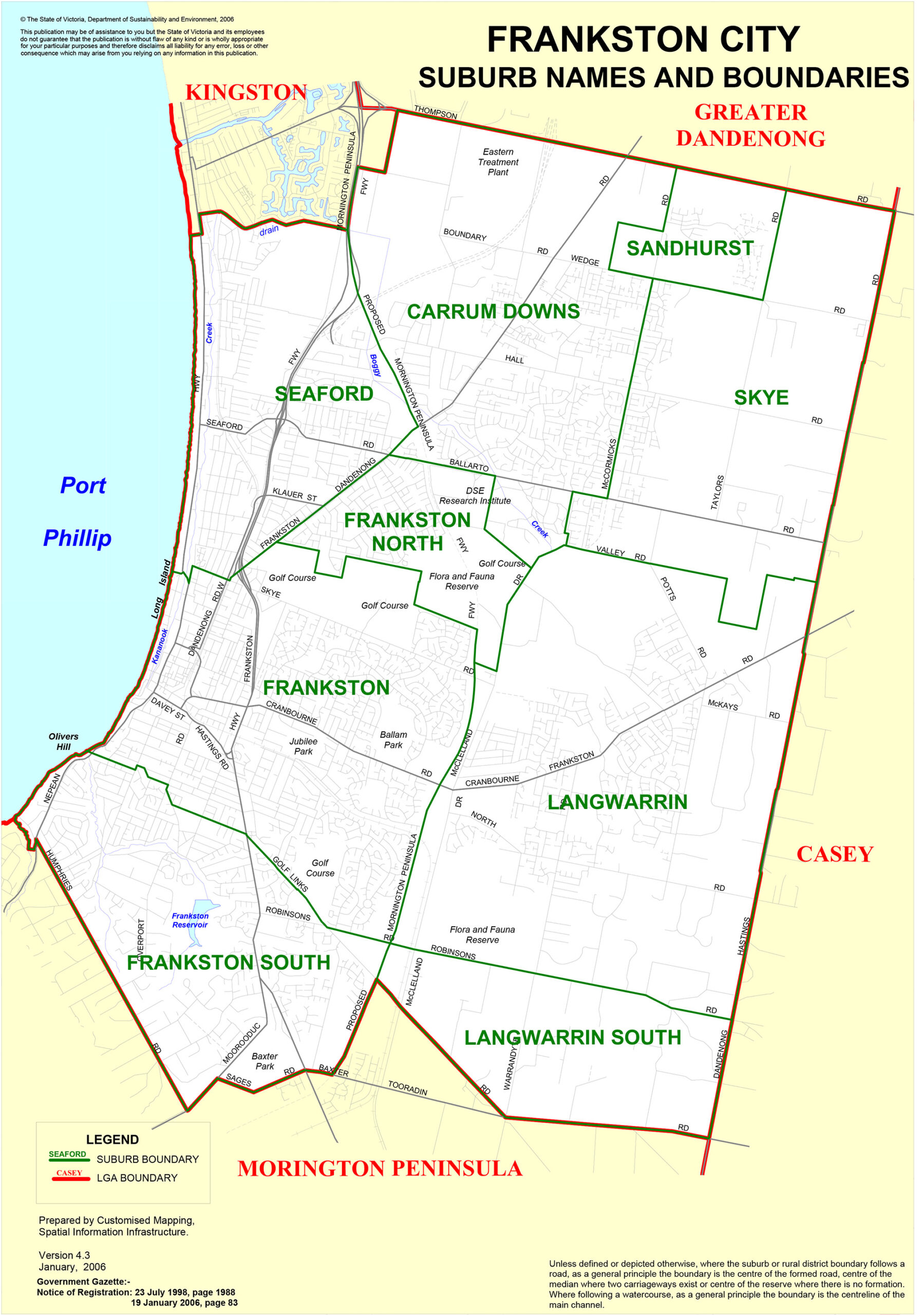
Frankston spent a few decades as Melbourne’s punchline. It’s now something closer to a genuine destination, and visitors who haven’t been recently will need to recalibrate. The waterfront has been overhauled, the arts precinct is serious, the beach is clean and the 220-metre pier is one of the most atmospheric structures on the bay.
The city functions simultaneously as the southern terminus of the Frankston rail line (making it the most transport-connected entry point to the Peninsula) and as a destination in its own right. Ten kilometres of beach. A raised timber boardwalk protecting the dune system. An arts centre with the second-largest proscenium arch stage in Victoria. These are not incidental features.
| Suburb | Character | Distance from CBD |
|---|---|---|
| Frankston | Beach, pier, boardwalk, arts centre; regional service hub | 41 km |
| Frankston South | Elevated residential; bushland pockets; adjacent to Mount Eliza | 44 km |
| Frankston North | Affordable residential; Carrum Downs retail proximity | 38 km |
| Langwarrin | Semi-rural; McClelland Sculpture Park; Flora and Fauna Reserve | 40 km |
| Seaford | Beach suburb; relaxed foreshore; between Carrum and Frankston | 36 km |
| Carrum Downs | Inland suburban; large retail zone; Langwarrin bushland proximity | 38 km |
| Karingal | Residential; Karingal Hub shopping; family-oriented | 42 km |
| Skye | Semi-rural fringe; transitioning to residential development | 41 km |
Frankston Beach is one of Port Phillip Bay’s cleanest, with consistent recognition in national beach quality assessments. Walk the pier at sunrise before anyone else arrives. Oliver’s Hill is the insider move: an elevated vantage above the bay’s northern arc with views that reward those who drive past the beach and up the hill.
McClelland Sculpture Park+Gallery in Langwarrin is a genuine surprise for first-timers. Australia’s first public gallery dedicated to art and sculpture sits on 16 hectares of coastal bushland. More than 100 sculptures populate the outdoor park; the indoor collection runs to 2,700 works. Opened in 1971, it remains undervisited relative to its quality. The Frankston Arts Centre (800 seats, major touring productions, strong community program) means Frankston residents don’t need to travel to the CBD for serious performing arts.
Getting there: The Frankston line runs express services from Flinders Street in approximately 55 minutes. By road, Peninsula Link from the Frankston Bypass is the fast route south. Frankston is also the connection point for bus services onto the Mornington Peninsula.
City of Greater Dandenong: Melbourne’s Most Diverse Municipality
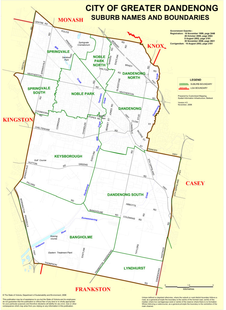
The numbers alone are striking. Residents from more than 150 birthplaces. Around 69% speaking a language other than English at home. A municipality of 158,000 people covering 130 square kilometres of Melbourne’s south-eastern middle ring. But statistics only take you so far with Greater Dandenong. Walk Springvale Road on a Saturday morning and the experience is immediate, sensory and entirely its own.
Greater Dandenong was formed in 1994 from the former City of Dandenong with parts absorbed from Springvale, Berwick and Cranbourne. What it inherited was a manufacturing and logistics base, a community already transformed by postwar European migration, and then a second transformation from the 1970s and 80s as Vietnamese and Cambodian refugees settled in numbers that reshaped the municipality’s cultural character entirely.
| Suburb | Character | Distance from CBD |
|---|---|---|
| Dandenong | Regional hub; Dandenong Market; major rail junction; multicultural retail | 29 km |
| Springvale | Little Saigon; Vietnamese, Cambodian and Chinese food precinct; 80% LOTE speakers | 24 km |
| Noble Park | Residential; Vietnamese and Sri Lankan communities; aquatic centre | 26 km |
| Keysborough | Industrial-to-residential transition; logistics and light industry | 28 km |
| Dandenong North | Residential; growing South Asian and Pacific Islander communities | 27 km |
| Lyndhurst | Industrial and logistics; southern boundary | 33 km |
The rest of Melbourne has been told about Springvale for decades. The locals who eat here regularly treat the advice with mild amusement. Yes, it is that good. Walk Springvale Road from the station toward the commercial strip and you are surrounded by Vietnamese bakeries selling banh mi and pandan cake, Cambodian restaurants with laminated menus of extraordinary range, Chinese BBQ shops with ducks in the window, and Asian supermarkets with produce you won’t find elsewhere in the south-east.
Hung Vuong is the pho institution. My Cambodia is the go-to for Phnom Penh noodles. Bun Bun Bakery does banh mi that city-side bakeries have spent years trying to replicate. Around 80% of the suburb’s residents speak a language other than English at home, which means the food is not performing for an audience. It simply is what it is. Dandenong itself has a growing Indian and Sri Lankan dining presence around Thomas Street, and Dandenong Market (operating in various forms since 1866) remains a weekly draw.
Getting there: Springvale station sits directly on the Pakenham line. Dandenong is a major rail hub where Pakenham and Cranbourne lines converge. EastLink and the Monash Freeway handle road traffic from the inner and middle suburbs.
City of Casey: Growth Corridor, Heritage Village and a Famous TV Mall
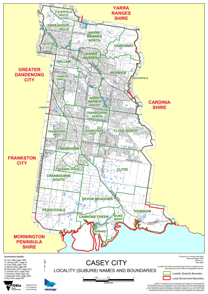
City of Casey contains multitudes. In Berwick’s older township, there are heritage streetscapes and established gardens. In Narre Warren, there is the second-largest shopping centre in Australia. In Clyde North, there are streets that didn’t exist five years ago. Casey is what Melbourne’s growth looks like: multiple phases of development stacked beside each other across a vast and still-expanding landscape.
Casey is consistently ranked among Australia’s three fastest-growing councils. The Casey-Cardinia corridor has received more residential development than any other Melbourne growth area over the past decade. Infrastructure investment follows, imperfectly and often behind schedule: the Cranbourne rail extension, Peninsula Link, the Mordialloc Freeway. The gap between housing delivery and services remains the defining frustration of outer-suburban life here.
| Suburb | Character | Distance from CBD |
|---|---|---|
| Berwick | Heritage township; village strip; established gardens; Dandenong Ranges backdrop | 40 km |
| Cranbourne | Regional hub; Royal Botanic Gardens; racecourse; RMIT campus | 45 km |
| Narre Warren | Westfield Fountain Gate; major commercial and service hub | 38 km |
| Endeavour Hills | Elevated residential; Dandenong Ranges views; community town centre | 35 km |
| Lynbrook | Planned suburb with lake and parkland; good cycling infrastructure | 42 km |
| Clyde North | Newest growth precinct; greenfield estates; rapidly expanding | 52 km |
| Hampton Park | Dense outer residential; younger families; diverse communities | 37 km |
| Doveton | Older established suburb; WWII-era stock; multicultural community | 32 km |
Royal Botanic Gardens Cranbourne is the outstanding natural attraction of the LGA: 363 hectares of native garden, including the internationally acclaimed Australian Garden designed by Taylor Cullity Lethlean. The Australian Garden takes the forms and textures of the Australian continent and translates them into a visitor experience unlike any other botanic garden in the country. The broader reserve has bushland walks and wetland areas requiring no interest in formal horticulture to enjoy.
Westfield Fountain Gate in Narre Warren is the second-largest shopping centre in Australia (yes, that Fountain Gate from Kath & Kim). Berwick Village is the counterpoint: a compact heritage strip with independent retailers, a weekend farmers market, and the kind of established-suburb character that the newer parts of Casey are working toward.
Getting there: The Cranbourne and Pakenham rail lines serve Narre Warren, Hallam, Berwick and Beaconsfield. Cranbourne is the terminus of the Cranbourne line. Peninsula Link and EastLink connect by freeway to the Mornington Peninsula south and inner Melbourne north.
Cardinia Shire: From Puffing Billy’s Terminus to Asparagus Country
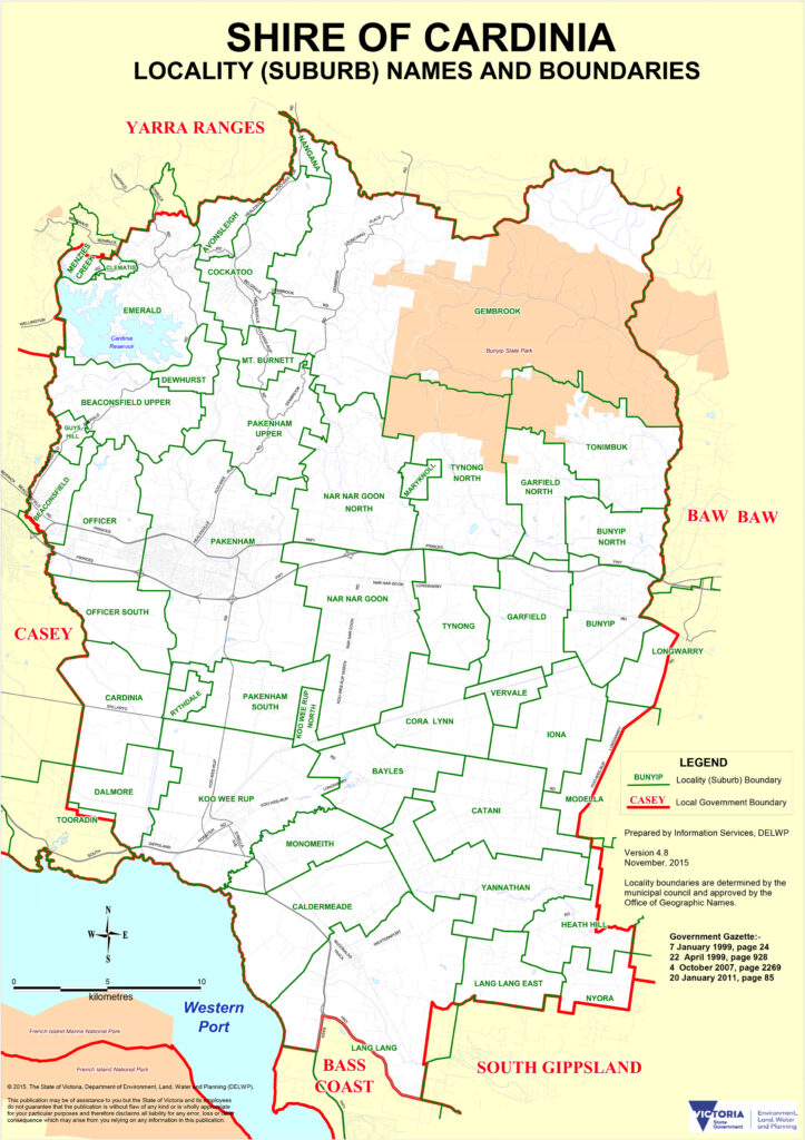
Cardinia is the shire with two distinct personalities and no apology for either. Drive west from Pakenham along the Princes Freeway corridor and you’re in some of Melbourne’s most active residential construction (Officer, Cardinia, Pakenham: greenfield estates rolling out at pace). Drive south along the South Gippsland Highway instead and the land opens into flat agricultural country, then turns hilly toward Gembrook. Different Cardinia entirely.
The Koo Wee Rup Swamp in the shire’s south was one of Victoria’s largest freshwater wetlands before it was drained from 1876 using hand-excavated channels. What replaced it is now the market-garden heart of Victoria: Koo Wee Rup (the name means ‘black fish swimming’) produces 90% of the state’s asparagus, along with celery and leeks. The agricultural productivity of the flat southern land is quietly extraordinary.
| Suburb/Town | Character | Distance from CBD |
|---|---|---|
| Pakenham | Major service town; rail terminus; rapidly growing urban centre | 55 km |
| Officer | Shire council HQ; master-planned growth suburb; Princes Freeway corridor | 49 km |
| Beaconsfield | Heritage township core; growth suburb interface; Dandenong Ranges fringe | 44 km |
| Cockatoo | Dandenong Ranges hilltop; rural lifestyle; on Puffing Billy route | 55 km |
| Gembrook | Puffing Billy eastern terminus; historic township; heritage tourism | 65 km |
| Koo Wee Rup | Agricultural hub; asparagus capital of Victoria; flat market-garden country | 60 km |
| Lang Lang | Small rural township; dairy country; South Gippsland Highway corridor | 70 km |
| Bunyip | Rural township; gateway to Bunyip State Park; Strzelecki Ranges proximity | 75 km |
The Puffing Billy Railway’s eastern terminus at Gembrook is the main tourist draw of Cardinia’s rural south. The narrow-gauge steam train (762mm track, opened 1900) runs from Belgrave in the Dandenong Ranges through Menzies Creek, Emerald, Cockatoo and on to Gembrook: roughly 24 km through forested hills, farmland and small townships. The railway closed in 1953 after a landslide, was saved by volunteers who began restoration in 1955, and has operated continuously since. More than 600 volunteers run the service today. Arriving at Gembrook by steam train is an unambiguously good experience (one the children will claim to have found obvious and the adults will privately rate highly). The township has heritage-character cafes and antique shops scaled to the train’s visitor traffic.
Getting there: Pakenham is the eastern terminus of Melbourne’s electrified suburban network (Pakenham line). Princes Freeway runs through Officer and Pakenham. The southern and rural parts of the shire are road-only. Puffing Billy connects Gembrook to Belgrave daily (except Christmas Day), and Belgrave connects to the city via the Belgrave train line.
Mornington Peninsula Shire: Wine, Water and Wellbeing
The Mornington Peninsula is Victoria’s most complete weekend escape. A 724 km2 wedge of land between Port Phillip Bay and Western Port, tapering south to the national park headland at Portsea and Flinders, it offers more concentrated pleasure per kilometre than almost anywhere else in the state. Wineries. Hot springs. Dolphin swims. Forty minutes on a ferry across the bay. Sandstone villages. Ocean beaches backed by National Park. The bay beaches stretching 28 km from Safety Beach to Portsea.
The Peninsula was wine country before most Australians knew Victoria had wine country. Production dates to 1886, when a Dromana wine won an honourable mention at the Intercontinental Exhibition. The modern wine renaissance began in the 1970s when cool-climate growers recognised that pinot noir and chardonnay would thrive in the elevated interior. Red Hill became the centre of that story, and it remains the address for the Peninsula’s best cellar doors.
| Town/Suburb | Character | Distance from CBD |
|---|---|---|
| Mornington | Main town; Wednesday market; harbour; cosmopolitan village strip | 55 km |
| Mount Eliza | Exclusive cliff-backed bayside; Walter Burley Griffin heritage estate | 48 km |
| Dromana | Bay town; Arthurs Seat gondola; wine-country gateway | 65 km |
| Safety Beach | Long sandy bay beach; popular sailing and swimming | 66 km |
| Rosebud | Family beach destination; 300m pier; calm shallow bay swimming | 72 km |
| Sorrento | Icon village; sandstone architecture; ferry crossing; dolphin swims | 93 km |
| Portsea | Prestige tip; Portsea Hotel; back beach surf; Point Nepean National Park | 100 km |
| Red Hill | Elevated wine country; cool-climate pinot; top cellar doors | 80 km |
| Fingal | Peninsula Hot Springs; the Peninsula’s wellness heart | 85 km |
| Flinders | Remote ocean-side township; Flinders Hotel; dramatic coastline | 95 km |
Book the Peninsula Hot Springs afternoon session before you do anything else on the Peninsula. At Fingal, mineral water at 50 degrees Celsius rises from an aquifer 637 metres underground, and flows untreated into more than 70 pools and bathing experiences across a natural landscape. The hilltop pool has 360-degree views. There is a cave pool, a Turkish steam room, a reflexology walk and a family bathing area. The Bath House suits all ages; the Spa Dreaming Centre is a quieter space for guests 16 and older. Peninsula Hot Springs is Victoria’s first natural thermal mineral springs site. Weekend sessions sell out weeks in advance. Book early. Go on a weekday in winter if the timetable allows, when the steam rising from the hilltop pool into cold air becomes its own reward.
Sorrento is the Peninsula’s most photographed and most loved village. White sands, clear bay water, boutique shopping and sandstone-block architecture dating to the 1870s all occupy roughly the same few streets. Take the Millionaire’s Walk clifftop trail above the bay for views and the satisfying experience of walking past some of Victoria’s most expensive residences from a public footpath.
From Sorrento Pier, Moonraker Dolphin Swims runs three-hour tours into Port Phillip Bay to swim with resident wild bottlenose dolphins and snorkel with Australian fur seals at Pope’s Eye. The dolphin sighting rate is around 92%. Thermal wetsuits and expert guides are provided. The Searoad Ferry runs year-round from Sorrento to Queenscliff on the Bellarine Peninsula: a 40-minute crossing across the bay mouth. Take the car. It opens the option of a loop drive that avoids retracing the Melbourne approach, coming back via Geelong instead.
Portsea, the final suburb on the bay side, is prestige Peninsula in concentrated form. The Portsea Hotel is among the best spots in Victoria to have lunch or watch a sunset over the bay. The back beach on the ocean side (inside Point Nepean National Park) offers surf conditions and a dramatically different character from the calm bay side just metres away.
Allocate a day to the elevated Red Hill corridor and the surrounding wine country. The Peninsula has around 200 vineyards and more than 50 cellar doors, with pinot noir and chardonnay as the signatures of the cool-climate interior. Red Hill Estate and Montalto both have destination restaurants alongside serious wine programs. Paringa Estate’s dining room has made multiple national restaurant lists. Arthurs Seat State Park sits above Dromana at 314 metres, with panoramic views over Port Phillip Bay and a gondola ride from the base in Dromana to the summit. Mount Eliza, between Frankston South and Mornington, is worth a detour for the Ranelagh Estate: a heritage-listed garden suburb designed by Walter Burley Griffin and Marion Mahony Griffin in 1924 (the same American architects responsible for Canberra’s original plan), consisting of about 800 houses on spacious tree-lined blocks.
Getting there: There is no rail access beyond Frankston. Most visitors drive via Peninsula Link from the Frankston Bypass, allowing approximately 90 minutes to Sorrento in reasonable traffic. Bus services connect Frankston station to the main Peninsula towns. The Searoad Ferry from Queenscliff is an alternative entry from the Bellarine side.
Frequently Asked Questions: Melbourne’s Southern Region
What beaches are in Melbourne’s Southern Region?
The Southern Region has more than 25 kilometres of continuous Port Phillip Bay coastline. Kingston LGA’s beaches run from Mentone through Parkdale, Mordialloc, Aspendale, Edithvale, Chelsea, Bonbeach and Carrum. Frankston has 10 kilometres of clean bay beach with its 220-metre pier. Further south, the Mornington Peninsula offers bay beaches from Safety Beach to Portsea, plus ocean surf beaches on the southern side of the headland inside Point Nepean National Park.
How do I get to the Mornington Peninsula from Melbourne?
By car, take Peninsula Link from the Frankston Bypass and allow approximately 90 minutes to Sorrento in light traffic. There is no train service beyond Frankston, but bus connections run from Frankston station to the main Peninsula towns. Alternatively, take the Searoad Ferry from Queenscliff (Bellarine Peninsula) to Sorrento: a scenic 40-minute crossing that avoids the Melbourne approach entirely and opens up a loop drive via Geelong on the return.
What is Peninsula Hot Springs and how do I book?
Peninsula Hot Springs at Fingal (near Rye) is Victoria’s first natural thermal mineral springs resort. Hot mineral water rises at 50 degrees Celsius from 637 metres underground and flows into more than 70 pools and bathing experiences, from hilltop panoramic pools to cave pools, steam rooms and private pool packages. The Bath House is family-friendly; the Spa Dreaming Centre is adults-only (16 and over). Bookings are essential and are available at peninsulahotsprings.com.
Why is Springvale famous for food?
Springvale has been known as Little Saigon since the 1970s and 80s, when significant Vietnamese and Cambodian communities settled in the area following the refugee migration wave. Today around 80% of the suburb’s residents speak a language other than English at home, and Springvale Road is lined with authentic pho restaurants, Cambodian eateries, Chinese BBQ shops, Vietnamese bakeries and Asian supermarkets. It is one of the most concentrated and authentic South-East Asian food precincts in Australia.
What is Greater Dandenong known for?
City of Greater Dandenong is Melbourne’s most culturally diverse municipality, with residents from more than 150 birthplaces and approximately 69% speaking a language other than English at home. It is best known for Springvale’s Vietnamese and Cambodian food precinct, Dandenong Market, and its role as a significant regional employment and logistics hub for south-east Melbourne.
Where does Puffing Billy end in the Southern Region?
Puffing Billy’s eastern terminus is Gembrook, a historic township in Cardinia Shire. The narrow-gauge steam train operates from Belgrave in the Dandenong Ranges through Menzies Creek, Emerald, Cockatoo and on to Gembrook, covering approximately 24 kilometres. Services run on most days except Christmas Day, operated by more than 600 dedicated volunteers.
Can I swim with dolphins near Melbourne?
Yes. Sorrento on the Mornington Peninsula is the base for dolphin and seal swim tours, with Moonraker Dolphin Swims among the established operators. Three-hour tours depart Sorrento Pier into Port Phillip Bay to find resident wild bottlenose dolphins and Australian fur seals at Pope’s Eye. Tours operate year-round, include thermal wetsuit hire and guided snorkelling, and have around a 92% dolphin sighting success rate.
What is the fastest-growing area in Melbourne’s south-east?
The Casey-Cardinia growth corridor is one of the fastest-growing residential zones in Australia. City of Casey is consistently ranked among the top three fastest-growing councils nationally. The active growth precincts are Clyde, Clyde North, Officer and Pakenham, where large-scale estate development is underway. Population across the combined Casey-Cardinia corridor is forecast to significantly exceed one million residents by the mid-2030s.
What wine varieties does the Mornington Peninsula produce?
The Mornington Peninsula is a cool-climate wine region best known for pinot noir and chardonnay, with the elevated Red Hill area particularly suited to both. Other varieties include pinot gris, pinot blanc, sauvignon blanc and arneis. The region has around 200 vineyards and more than 50 cellar doors open to visitors, making it one of Victoria’s most accessible wine-touring regions.
How do I get from Sorrento to Queenscliff?
Searoad Ferries operates a vehicle and passenger service between Sorrento (Mornington Peninsula) and Queenscliff (Bellarine Peninsula) year-round. The crossing takes approximately 40 minutes. The route is popular for a Peninsula loop itinerary: drive down the Peninsula, cross by ferry, and return to Melbourne via Geelong and the Princes Freeway, avoiding a repeat of the approach drive.