
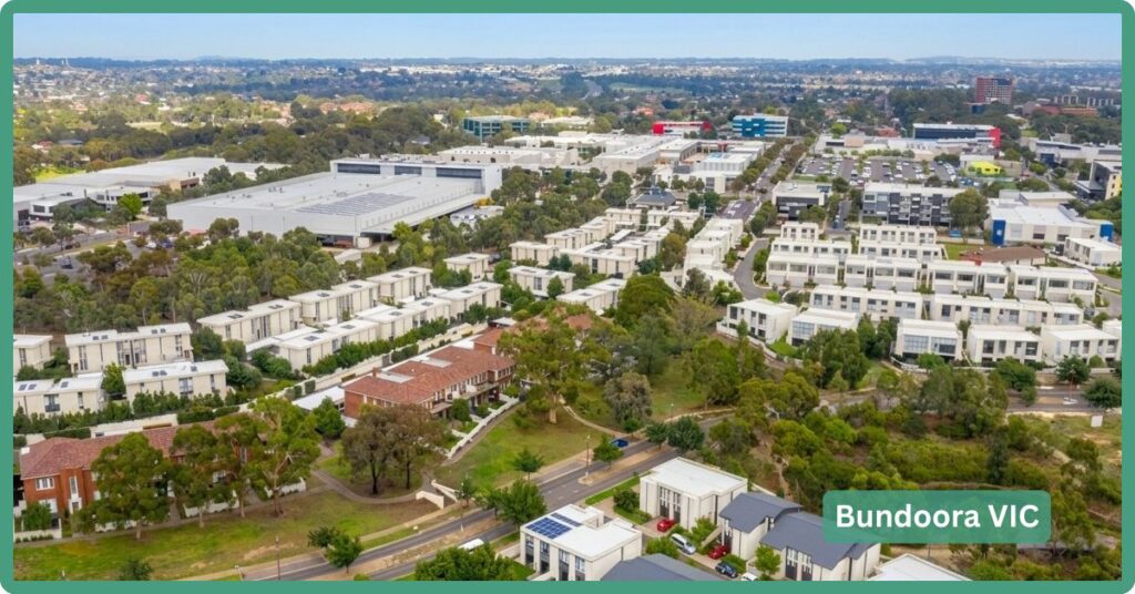
Bundoora is what happens when you build one of Victoria’s biggest universities on top of a suburb and never quite finish deciding whose suburb it is. It’s split across three councils, has zero train stations of its own, and its median age matches the state average only because a huge 20-something student cohort is cancelling out an equally large population of long-settled Italian and Greek homeowners who bought here decades ago. Don’t come here expecting a train line or a genuine town centre; come here for a 235-hectare university campus with its own wildlife sanctuary, a 180-hectare park with a working farm, and housing that’s still, remarkably, cheaper than the northern suburbs next door with a station.
Bundoora Boundary Map
Bundoora is genuinely unusual among Melbourne suburbs in spanning three separate councils: the City of Banyule (roughly the south-western section around La Trobe University’s main campus and Bundoora Park), the City of Darebin (the western section, including Bundoora Homestead and Bundoora Park Farm, both of which Darebin manages directly), and the City of Whittlesea (the northern and eastern section, which holds the largest population share). It borders Mill Park to the north, Greensborough, Watsonia and Macleod to the east, Heidelberg West to the south, and Kingsbury, Reservoir and Thomastown to the west, an unusually large, elongated footprint that also means the suburb sits across three federal electorates (Cooper, Jagajaga and Scullin).
Quick Facts
| LGA | City of Banyule; the City of Darebin; City of Whittlesea |
| Median House Price | $870,000-$900,000 (Woodards / PropertyValue.com.au, 12 months to July 2026), up around 4% year-on-year |
| Median Unit Price | $427,000-$495,000 depending on source (PropertyValue.com.au vs Chamberlain Property Advocates, mid-2026); genuine spread, not a typo |
| Population | 28,068 (2021 Census), effectively flat on 28,653 (2016 Census) |
| Growth Rate | Modest and infill-driven: Banyule’s Bundoora forecast area +8% by 2041, Whittlesea’s +25% by 2041 (forecast.id) |
| Transport | Tram route 86 and 15 bus routes, both delivered; zero train stations in-suburb; SRL North’s proposed Bundoora station is an unfunded, decades-away proposal |
| Crime Rate (LGA) | Split across three LGAs; Darebin LGA runs above the Victorian average |
| Childcare Availability | Adequate (20s-low-30s services around the suburb), with a standout Exceeding-NQS centre on the La Trobe campus itself |
| Zoned School | Bundoora Primary and Norris Bank Primary; Bundoora Secondary College (government, years 7-12) in-suburb |
| Best For | Students, university staff and value-focused buyers who don’t need a train station; long-settled families already here who bought before the market moved on |
Our Verdict
If a train station is non-negotiable, Bundoora isn’t for you, it has none, and the nearest options (Macleod, Watsonia) sit in neighbouring suburbs and come at a real price premium. If what you actually want is proximity to a major university, a genuinely large parks-and-wildlife footprint on your doorstep, and housing that’s still cheaper than comparable northern suburbs with rail access, Bundoora is a legitimately good buy, provided you accept you’ll be driving, catching a bus, or riding the 86 tram everywhere.
It suits university staff and postgraduate buyers who want to live near La Trobe or RMIT’s Bundoora campuses, investors chasing student rental demand (group households run at 6.3% locally versus 4.0% across Victoria, a clear share-house signature), and value-focused buyers happy to trade a train station for lower entry prices. It’s a weaker fit for commuters who need a fast, direct CBD run every day, and for families chasing a conventional, settled family-suburb feel, Bundoora’s population skews unusually young-adult (20-24 is the single largest age cohort) rather than family-heavy, and prime family cohorts like 35-39 year olds are actually under-represented against the state average.
Weighed against its closest neighbours, the picture is straightforward. Mill Park, directly north along the same Plenty Road corridor, offers a more conventional family-suburb feel with houses priced just below Bundoora’s ($865,000) but units priced well above ($592,000, reflecting less student-oriented stock), and famously tight rental vacancy. Macleod, to the east, is the suburb you buy in if a train station matters more than anything else, at a real and quantifiable cost: a $1,195,500 house median and $750,000 unit median, both well above Bundoora’s. Bundoora sits below both on price and above both on university-adjacent amenity, which is exactly the trade a buyer here is making.
The Backstory: Heritage & Origins
The name comes from “Kelbundoora,” a 19th-century Wurundjeri man of the Kurnaj-berring clan, the original inhabitants of the area, who used the district’s large wetlands before European settlement. Europeans arrived in 1835 in what was then the Parish of Keelbundora; the land was surveyed in 1837 and auctioned in Melbourne the following year, with early landholders including members of the Port Phillip Association grazing sheep here. Bundoora Post Office opened in 1863.
The suburb’s clearest heritage anchor is Bundoora Park Homestead, built in 1899-1900 for horse breeder John Matthew Vincent Smith on a 242-hectare property, a Federation Queen Anne-style building by architect Sydney Herbert Wilson (who also designed Malvern Town Hall), with significant stained glass and an intact set of pyrography staircase panels (Victorian Heritage Database, state-registered 1995). After WWI the Commonwealth Government converted it into the Bundoora Convalescent Farm, Victoria’s first dedicated psychiatric facility for returned servicemen, later the Mental Repatriation Hospital, which operated until 1993. In 1997 the Victorian Government gifted the homestead to the City of Darebin, the clearest evidence that Darebin holds a genuine civic stake in Bundoora, not just a nominal administrative sliver.
Postwar migration left a visible mark too: Floridia Cheese Company was founded here in 1955 by the Montalto family, an early marker of the Italian migration that still shows up strongly in today’s Census ancestry figures. Parts of Bundoora previously sat within the former City of Preston and the former Shire of Diamond Valley, both abolished in the 1994 council amalgamations, one more layer in a suburb whose governance has rarely been simple.
The Big Build & Growth Story
The dominant current project is La Trobe University’s own transformation of its 235-hectare Bundoora campus. The university has selected Plenary as preferred development partner for what’s being widely reported as a $5 billion, 30-year masterplan (branded “La Trobe University City”), though a smaller $3.26 billion figure also appears in some coverage for a differently-scoped phase, treat the $5 billion figure as the headline number but the exact scope as still settling. The plan is structured around four neighbourhoods: North Village (residential), East Village (near Macleod station, pulling part of the university’s growth toward the one nearby suburb that actually has rail access), South Village (research and commercial partnerships) and City Centre (expanded academic and retail facilities), with a stated focus on health innovation, sustainable agriculture, AI and food systems research. The one genuinely funded, dated, near-term piece of this is an $82 million University Health Clinic, under construction and targeted for completion in mid-2026; treat everything else in the $5 billion vision as long-range rather than scheduled.
On transport, Bundoora is one of seven suburbs proposed for a station under Suburban Rail Loop North, alongside Doncaster, Heidelberg, Reservoir, Fawkner, Broadmeadows and Melbourne Airport. This remains in early planning only, active tunnelling is happening on the separate SRL East project, not SRL North, and government material itself describes SRL North’s station and precinct locations as preliminary. Treat any specific opening year you see quoted (estimates range from the early 2040s to considerably later) as unconfirmed and likely to shift; the honest framing is “planned, unfunded for construction, realistically decades away.”
More concrete near-term infrastructure sits in roads rather than rail: the Metropolitan Ring Road (M80) is being widened near Bundoora as a connecting piece of the North East Link project, aiming to pull roughly 19,000 vehicles a day off Greensborough Road once complete, and Plenty Road is subject to a $139 million duplication and intersection upgrade. The Bundoora/RMIT tram interchange has also recently been upgraded. None of this delivers a train station, but it’s real, funded, and happening now, which is more than can be said for SRL North.
Getting Around Bundoora
Bundoora has no train station of its own, full stop. The nearest options are Macleod and Watsonia on the Hurstbridge line, or South Morang, Thomastown, Keon Park and Reservoir on the Mernda line, all in adjoining suburbs and reached by bus. What it does have is tram route 86, a 22.2km run terminating at the RMIT/Plenty Road stop in Bundoora and taking around 84 minutes end-to-end into the city via Reservoir, Preston, Northcote, Fitzroy and the CBD. It also has an unusually dense network of 15 bus routes, most converging on La Trobe University and RMIT Bundoora as hubs (key routes include 250 and 350 direct to the CBD, 301 to Reservoir station, 382/383/386/387 linking Mill Park and the Mernda line, and 548/550/551/561/564/566/570 linking Macleod, Heidelberg, South Morang and Thomastown stations).
That density of surface transit doesn’t fully offset the lack of rail: Census figures show only 5.3% of employed Bundoora residents travelled to work by public transport, against 58.3% by car. Plenty Road is the suburb’s main north-south spine (currently being duplicated), with the Metropolitan Ring Road running along its boundary. Drive time to the CBD is realistically in the 25-40 minute range off-peak and considerably longer at peak, treat any specific figure as an estimate pending a live traffic check rather than a verified constant. The Western Ring Road Trail and Darebin Creek Trail both pass through the suburb for cyclists and walkers.
What do the Crime Stats Say?
Victorian crime data is published at council level, and because Bundoora spans three councils there’s no single official “Bundoora crime rate”. Statewide, Victoria’s recorded criminal incident rate rose 2.3% to 6,668.6 per 100,000 people in the year to December 2025. The City of Darebin, the LGA with the most directly attributable published figure covering part of Bundoora, runs meaningfully above the state average at roughly 12,362 offences per 100,000 (year to September 2025), up 16% on five years earlier, driven mostly by property and deception offences.
Schools and Childcare
Bundoora Primary School and Norris Bank Primary School cover government primary schooling, with Bundoora Secondary College the local government secondary option (years 7-12). Catholic options include Parade College (boys, with a Bundoora campus, 2025 median VCE study score of 30, solidly mid-table rather than academically elite) and St Damian’s Catholic Primary School, with Loyola College nearby in neighbouring Watsonia also serving Bundoora families. The Concord School caters to students with additional learning needs, and Northside Christian College offers an independent option.
The suburb’s defining education landmark is La Trobe University itself, founded in 1964 as Victoria’s third university and based here on a 235-hectare main campus, with RMIT also running a Bundoora West Campus at the tram 86 terminus and an East Campus further along housing its wind tunnel and sports statistics research group.
Childcare supply sits in a realistic working range of the low-20s to low-30s services in and around the suburb, not acutely tight, one aggregator found 17 of 22 listed centres had vacancies at the time of searching. The standout is the La Trobe University Community Children’s Centre on campus, rated Exceeding NQS across all seven quality areas, a genuinely strong, purpose-built centre most suburb childcare markets don’t have anywhere near this calibre embedded in them.
Hospitals and Healthcare
Bundoora has real in-suburb healthcare infrastructure: Northpark Private Hospital, La Trobe Private Hospital, and the Bundoora Extended Care Centre (part of the Northern Health network, sub-acute care for over 100 inpatients plus community outpatients). The nearest major public hospitals are The Northern Hospital in Epping (roughly 10km) and the Austin Hospital in Heidelberg (roughly 13-14km), both outside the suburb but within a reasonable drive. Once complete in mid-2026, the $82 million University Health Clinic on La Trobe’s campus will add a further, more contemporary facility directly in-suburb.
Parks, Attractions & Fitness
Bundoora Park is the headline asset, 180 hectares containing Mount Cooper (often claimed, though not definitively confirmed, as metropolitan Melbourne’s highest point), a public golf course, and Bundoora Park Farm, a free-entry, hands-on animal experience with sheep, goats, alpacas, cows and more, daily feeding and milking sessions, a tractor ride through an adjoining wildlife reserve where kangaroos and emus turn up, and fully paved, pram-and-wheelchair-accessible paths. It’s managed by the City of Darebin, another concrete example of Darebin’s genuine stake in the suburb rather than a nominal boundary line.
The Gresswell Nature Conservation Reserves add another 70 hectares of protected habitat across Gresswell Forest, Gresswell Hill and the Gresswell Habitat Link, which connects through to La Trobe Wildlife Sanctuary on the university campus itself, home to wombats, kangaroos and significant birdlife across wetlands and remnant Red Gum woodland. For a suburb just 15km from the CBD, having a functioning wildlife sanctuary and nature reserve network at this scale is genuinely unusual and a real point of difference against comparable northern suburbs. Golfers get three courses to choose from (Bundoora Park, Strathallan, Kings Park), and the Western Ring Road and Darebin Creek trails cover walking and cycling.
Sport-wise, Bundoora punches well above its size: La Trobe Sports Park, adjacent to the main campus, is home to the Matildas (Australia’s women’s national football team) and the Victorian Rugby Centre of Excellence (Melbourne Rebels Women and Rugby Victoria’s high-performance base), two elite-sport facilities most portal pages don’t even mention.
Shopping and Dining
Bundoora Square, on Plenty Road at Settlement Road, is the suburb’s main shopping centre, a modern, part-enclosed neighbourhood centre with roughly 70 specialty retailers plus Woolworths and Coles as anchors, open 6am-10pm daily. University Hill, a business park near La Trobe, adds a DFO-style outlet mall (Uni Hill Factory Outlets) alongside corporate tenants including Continental AG’s Australian headquarters. There’s no dedicated library in Bundoora itself, the nearest are in Watsonia, Diamond Valley and Mill Park, a genuine local gap worth knowing about if that matters to you. Greensborough Lanes bowling alley, despite the name, is actually located in Bundoora.
What It’s Actually Like to Live Here
Bundoora’s Census data tells a genuinely bimodal story. It’s simultaneously a university town, 36.8% of local students are in tertiary education against a 24.5% state rate, group households run at 6.3% against 4.0% statewide, and a suburb of long-settled outright homeowners, 36.5% own outright, above the state average, with heavy Italian (12.4%, more than double the state rate), Chinese (13.8%) and Greek-linked Eastern Orthodox (9.6%, nearly triple the state rate) ancestry showing an established migrant community that bought in decades ago and stayed. Median personal and household incomes both sit below the Victorian average, consistent with a population skewed toward students and retirees rather than prime-earning-age professionals. Despite the tram and bus density, car dependency is high (92% of dwellings have at least one vehicle, 53% of workers drive to work), a direct consequence of having no train station. Population growth here is genuinely modest, essentially flat between the 2016 and 2021 Censuses, so don’t buy in expecting a “growth corridor” story; the change happening in Bundoora is infill and university-led redevelopment, not new rooftops.
Trade-offs
No train station, and it’s not getting one any time soon; SRL North’s proposed Bundoora stop is realistically decades away and unfunded for construction. Public transport mode share to work sits at just 5.3%, so day-to-day life here leans heavily on a car even with the tram and bus network. Price data itself is messier than usual, house medians converge reasonably well around $870,000-$900,000, but unit medians genuinely diverge between sources ($427,000 to $495,000), so treat any single quoted figure with some caution until you’ve checked a live listing. And the suburb’s population skews young-adult and transient (students) alongside old and settled (established migrant homeowners), with the conventional prime-family-age cohorts notably thinner than the state average, worth knowing if you’re expecting a classic family-suburb social fabric.
FAQ
What are property prices like in Bundoora? House medians sit around $870,000-$900,000 (Woodards/PropertyValue.com.au, mid-2026), up roughly 4% year-on-year. Unit prices are harder to pin down, reported anywhere from $427,000 to $495,000 depending on the source.
Does Bundoora have a train station? No. The nearest stations are Macleod and Watsonia on the Hurstbridge line, or South Morang, Thomastown, Keon Park and Reservoir on the Mernda line, all in neighbouring suburbs. Bundoora is served instead by tram route 86 and 15 bus routes.
Is Bundoora safe? Crime is reported at council level, and Bundoora spans three councils (Banyule, Darebin, Whittlesea), so there’s no single official suburb rate. The City of Darebin, which covers part of Bundoora, runs above the Victorian average; Banyule and Whittlesea figures need direct verification.
What are the best schools zoned for Bundoora? Bundoora Primary and Norris Bank Primary cover government primary schooling, with Bundoora Secondary College the local government secondary option. Parade College and St Damian’s are the main Catholic options, and La Trobe University is the suburb’s dominant education landmark.
References
- Australian Bureau of Statistics. 2021 Census All Persons QuickStats, Bundoora (SAL20399); 2016 Census, Bundoora (SSC20397).
- profile.id / forecast.id. City of Banyule and City of Whittlesea population and forecast summaries, Bundoora profile areas.
- City of Darebin. Bundoora, Kingsbury and Macleod suburb guide; Bundoora Park Farm page.
- Crime Statistics Agency Victoria. Latest Victorian crime data, year ending December 2025.
- Victoria’s Big Build, Department of Transport and Planning. Suburban Rail Loop North project pages.
- Department of Transport and Planning. M80 Ring Road and Plenty Road upgrade project pages.
- Public Transport Victoria / Transport Victoria. Tram route 86 and Bundoora bus route pages.
- Victorian Heritage Database. Bundoora Park Homestead, Place ID H1091.
- Darebin Heritage. Bundoora Homestead building history.
- Parks Victoria. Gresswell Nature Conservation Reserves; La Trobe Wildlife Sanctuary area.
- Australian Children’s Education and Care Quality Authority (ACECQA). National Registers, La Trobe University Community Children’s Centre.
- La Trobe University / Plenary. La Trobe University City masterplan announcements.
- Victorian Department of Education. Victorian State Schools Directory, Bundoora Primary and Bundoora Secondary College.