
Doreen is a suburb split down the middle, and not just in the loose way every suburb has a “better” and “worse” side. Yan Yean Road genuinely divides it between two separate councils: a suburbanising western half in the City of Whittlesea, contiguous with Mernda and South Morang, and a rural eastern half in the Shire of Nillumbik, contiguous with Yarrambat and Nutfield. That’s a real structural fact that shapes everything from which population figures apply to which crime statistics are even relevant, and no other suburb in this area straddles two councils quite like this. The nearest train station is 7-10 minutes away, though Melbourne’s oldest reservoir sits right on the doorstep, a genuine point of difference from the flatter growth suburbs further west.
Doreen Boundary Map
Doreen sits roughly 30km north-east of the Melbourne CBD, split by Yan Yean Road between the City of Whittlesea to the west and the Shire of Nillumbik to the east, bordered by Mernda and South Morang to the south-west and Yarrambat to the east.
Quick Facts
| LGA | City of Whittlesea/Shire of Nillumbik |
| Median House Price | $803,000-$820,000 (Domain and PropertyValue/CoreLogic, 2026); a third source (HtAG) cites $1,011,180 but appears to use a different methodology, treated as an outlier |
| Median Unit Price | $600,000, up 7.14% annually, though based on only around 16 sales in the past 12 months, a thin sample |
| Population | 27,122 (2021 Census, full suburb); a separate City of Whittlesea figure of 29,041 (2024) covers only the Whittlesea-LGA portion, not the full suburb |
| Growth Rate | +27.4% 2016-2021; no verified current point estimate exists, treat as “high-20s-thousands, still climbing” |
| Transport | No railway station within the suburb. Nearest is Mernda station, in neighbouring Mernda, the line’s terminus |
| Crime Rate (LGA) | City of Whittlesea: sources conflict on the exact count (13,890 incidents in 2025 vs a separate 18,346-offence figure), but vehicle theft is up sharply (+70%+) |
| Childcare Availability | Around 8 long day care services suburb-wide per one aggregator; at least two local services too new to have a published NQS rating |
| School Zone Quality | Doreen Primary (the suburb’s oldest school, tracing to 1867) and the still-expanding Marymede Catholic College Doreen campus (opened 2024) serve the area; no ranking data confirmed |
| Best For | Buyers wanting larger blocks and a rural-fringe feel within the Whittlesea growth corridor, comfortable without walk-to-rail access |
Our Verdict
Doreen is an interesting outpost on Melbourne’s outer fringes, balancing fast-growing housing estates with a distinctly semi-rural backdrop. Take a look here if you want more of a rural-fringe feel than the flatter, more built-out growth suburbs further west offer, and you’re comfortable without a train station of your own; Melbourne’s oldest reservoir sits on your doorstep, and that’s a genuine, distinctive amenity most of this growth corridor can’t match. Don’t come here expecting rail access any time soon; the nearest station is in neighbouring Mernda, and the live rail conversation in this part of Melbourne is actually a feasibility study for a Wollert extension well to the west, not anything aimed at Doreen itself.
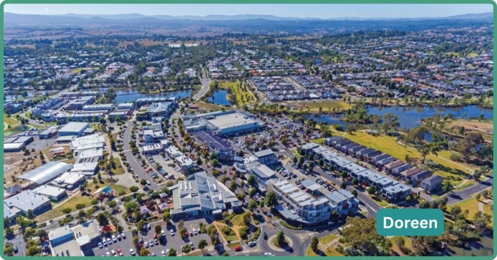
It suits people who want a larger-block, semi-rural character within commuting distance of the Whittlesea growth corridor’s amenities, and who don’t mind driving or busing to Mernda station for their rail connection. It’s a weaker fit for anyone who wants walk-to-rail access today, or anyone who’d find the suburb’s genuine split across two council areas, and the resulting patchwork of which statistics and services apply where, more confusing than they’d like.
Weighed against its closest neighbours, Doreen trades Mernda’s existing train station for larger blocks and a quieter, more rural-fringe feel; buyers choosing between the two are essentially trading transport access for space. South Morang, further south again, offers a more established amenity base and its own station, useful for buyers who want more built infrastructure today rather than betting on the future. Nearby Wollert is pinning its own rail hopes on the same feasibility-study conversation, but approaches it from the opposite side of the corridor. Whittlesea township itself, further north in the same LGA, is the genuinely rural alternative for anyone who wants Doreen’s semi-rural character taken even further.
The Doreen Backstory: Heritage & Origins
European settlement here dates to 1844, when Patrick Reid took up a rural holding he named Hazel Glen. The land was subdivided into farmland from 1862, prompting further settlement, with a Methodist church built that year at the corner of Yan Yean Road and Chapel Lane. A post office opened on 8 December 1870 under the name Hazelglen, and it was renamed Doreen in 1895 by the Victorian Postmaster-General of the time, John Gavan Duffy.
Hazel Glen Common School, built in 1867 and formally recognised by the government on 1 July 1868 as School No. 945, is the suburb’s oldest continuously-linked institution and survives today as Doreen Primary School. Modern residential development followed two distinct patterns: rural-residential estates and nurseries to the south, and the Laurimar estate to the north, developed by Delfin and marketed on a “semi-rural” living proposition. The suburb’s defining structural fact, worth restating plainly, is that it’s explicitly split by Yan Yean Road into a rural Nillumbik-LGA eastern half and a suburbanised Whittlesea-LGA western half.
The Growth Story
Population grew from 21,298 at the 2016 Census to 27,122 in 2021, a 27.4% rise. A separate figure from the City of Whittlesea’s own community profile puts the 2024 population at 29,041, but this is worth flagging clearly: that figure covers only the Whittlesea-LGA portion of Doreen, not the full ABS-defined suburb, which also includes the rural Nillumbik-side population. No verified current point estimate for the whole suburb exists beyond that, so we’ll assume the population as high-20s-thousands and still climbing rather than asserting a precise current figure. On the school infrastructure side, Marymede Catholic College’s Doreen campus, which opened in 2024 for Year 7 students, is still actively expanding: a fitness centre, basketball courts, performing arts and food technology facilities were added through 2025, with an administration building, extra classrooms and a library and resource centre planned for 2026, and the school adding one year level per year until it reaches full Year 7 to 12 provision by 2029.
Getting Around: Transport & Distances
Doreen has no railway station within its own boundaries. The nearest is Mernda station, in neighbouring Mernda, which is also the terminus of the Mernda line, itself opened in 2018, six months ahead of schedule. Worth correcting directly: the live, funded rail conversation in this part of Melbourne isn’t a “Doreen extension.” It’s a feasibility study for extending the existing line from Lalor and Epping through Epping North to Wollert, well to the west of Doreen.
The City of Whittlesea’s own Integrated Transport Plan 2024-2034 aspires to see that extension reach Wollert by 2030, but as of reporting in December 2025, the feasibility study itself still hadn’t been fully released, and local advocates, including the council’s own CEO, have been publicly pushing for it, with the project reportedly years behind the five-year commitment originally set out in the state’s 2017 infrastructure plan. Doreen itself has no current or announced rail project of its own; any future rail access would most likely still come via Mernda station rather than a station within Doreen.
Mernda Station is no more than a 7-10-minute drive for anyone in the suburb and 6-25 mins by bus depending on where you are. From Mernda station to the CBD, it’s around a 63 min journey.
Bus routes 381, 385, 388 and 389 serve the suburb, operated by Dysons following the 2016 Plenty Valley network restructure, connecting to Mernda station, Diamond Creek station, Whittlesea and Greensborough Plaza.
On roads, the Plenty Road upgrade between Bush Boulevard and Bridge Inn Road was completed back in mid-2021, so treat any reference to that project as historical rather than current. The live road project affecting Doreen right now is the Yan Yean Road Upgrade Stage 2, running from Kurrak Road to Bridge Inn Road through Yarrambat and Doreen, delivering lane duplication, nine intersection upgrades and around 11 kilometres of new walking and cycling paths, with the northern package underway and the southern package targeted to start around mid-2026.
Whilst the Melbourne CBD is only 35km, in peak, the commute can range from 55–75 minutes on a good day through to 75–90+ minutes if there’s an accident. Off-peak it’s not as bad; a good run can be 35–45 minutes. For those doing a daily CBD commute, it’s rough, and most choose the train, and that’s a slog too at just over an hour plus getting to/from the station.
Crime and Safety, Honestly
Victorian crime data is published at City of Whittlesea LGA level, not suburb level, so there’s no Doreen-specific figure. Sources here genuinely conflict on the exact count: local news reporting cites 13,890 criminal incidents in 2025 versus 12,892 in 2024, a 7.7% rise, while a separate aggregator cites 18,346 reported offences, equating to a rate of 7,998 per 100,000 people, for the same broad period. These two figures use different count bases, incidents versus offences, and we shouldn’t try to reconcile them into one number. What’s more consistently reported across sources is the trend in specific offence types: vehicle-related theft has risen sharply in the LGA, with motor vehicle theft up around 73% and theft from motor vehicles up around 71%, alongside meaningful rises in residential burglary. Victoria’s statewide recorded offence rate sat at 8,885.5 per 100,000 for the year ending December 2025, up 2.4% on the prior year; on the lower of the two Whittlesea figures cited above, the LGA would sit modestly below that state rate, but given the underlying source conflict, this profile presents that comparison cautiously rather than as a settled fact.
Schools and Childcare
Doreen Primary School, formerly Hazel Glen Common School and tracing back to 1867, is the suburb’s oldest school and its main government primary option today. Marymede Catholic College’s Doreen campus opened in 2024 for Year 7 students and is expanding one year level at a time toward full Year 7 to 12 provision by 2029, with substantial facilities still under construction through 2025 and 2026. St Paul the Apostle Catholic Primary School, which opened in February 2015, sits adjacent to Marymede’s Doreen campus. Ashley Park Primary School is a newer government school serving the area.
Childcare supply sits at around eight long day care services suburb-wide per one aggregator source, alongside similar numbers of before and after school care and vacation care options; this figure wasn’t independently cross-checked against the ACECQA National Registers directly, so treat it as approximate. Orchard Road Community and Early Learning Centre, run by Y Whittlesea, offers eight rooms from nursery through kindergarten age with a waitlist managed via Xplor. Whittlesea Council also runs a family day care service in Doreen, described as smaller than average with around seven places. At least two approved local childcare services don’t yet have a published National Quality Standard rating, a genuine supply-transparency gap common in fast-growing corridors where new services often open before their first quality assessment visit.
Hospitals and Healthcare
In the suburb, there are five GP clinics, all centred around the Laurimar Town Centre. Northern Hospital, in Epping (24 mins by car), and healthcare facilities in nearby Mernda and South Morang service this part of the corridor.
Get Outside: Parks, Attractions & Fitness
Laurimar Recreation Reserve Sportsfield provides two sports fields, walking trails and a skatepark. It connects to the Laurimar Wetlands, a north-south linear reserve with trails leading to smaller parks and the larger Hill Top Park that features a playground, kickabout space and trails.
Yan Yean Reservoir sits to the suburb’s north and is a genuine, distinctive local asset: Melbourne’s oldest reservoir, with a playground, lookout points and picnic areas, offering a heritage and open-space feature that none of the flatter, more built-out growth suburbs further west in this series can match.
The suburb’s terrain itself is hillier than most of its western neighbours, bordering the Yarra Ranges foothills to the east and north and the forested banks of the Plenty River to the west, a genuinely different topographic character from the basalt-plain growth corridors nearby. Further recreational draws, including Funfields Water Park, Torourrong Reservoir, Bear’s Castle and the old Whittlesea courthouse, now a visitor information centre, sit in or near Whittlesea township..
Shopping and Dining
Laurimar Town Centre handles daily needs, including a Woolworths, two gyms, fast food options, a couple of Asian restaurants, and numerous specialty stores. In neighbouring Mernda there is a Bunnings, another Woolworths anchored shopping centre and a Coles.
For more, locals head to Westfield Plenty Valley in Morang, about 20 min by car and easily accessed by train too.
What It’s Actually Like to Live Here
Life in Doreen revolves around family, space and the outdoors. Residents enjoy modern homes, parks and a semi-rural backdrop, but often accept longer commutes and ongoing infrastructure catch-up as the price of that lifestyle.
This is a young, family-forming suburb: median age 33 at the 2021 Census, notably younger than the state median. Owner-occupancy sits high at 73.6%, consistent with a mortgage-belt growth suburb rather than a renter-heavy one. Median weekly household income was $2,151, median monthly mortgage repayment $2,000, and median weekly rent $397 at the 2021 Census, though these figures are now several years old and likely understate current costs given the price growth discussed above.
The average household size is three people, across 7,542 families and 9,284 private dwellings. Cultural makeup data available in this research only goes back to the 2016 Census, which showed 81% Australian-born residents with England, India, New Zealand, Italy and Sri Lanka as the leading overseas birthplaces; that data is now roughly a decade old, and a fast-growing corridor like Doreen likely has a materially different current profile, probably more South Asian in composition consistent with broader Whittlesea trends.
Day to day, this is a suburb genuinely defined by its split character: a suburbanising west that looks and functions much like its Mernda and South Morang neighbours, and a rural east that retains a genuinely semi-rural, larger-block feel. For buyers who want that rural-fringe character without moving all the way out to a genuinely rural town, that’s the appeal.
Trade-offs
No train station within the suburb, with the nearest option in neighbouring Mernda and no dedicated rail project of Doreen’s own on the table, although that’s mostly an issue for residents in the far north of the suburb should they need convenient rail access. The suburb’s genuine split across two local government areas means population figures, and potentially other local statistics, can vary depending on which geography a source is using, a real source of confusion worth understanding before you rely on any single number.
FAQ
Does Doreen have a train station? No. The nearest is Mernda station in neighbouring Mernda, which is also the terminus of the Mernda line. No extension into Doreen itself is currently planned.
Is Doreen getting a train line extension? The live, funded conversation is a feasibility study for extending the line from Lalor and Epping through to Wollert, well to the west of Doreen, not a project aimed at Doreen directly. As of late 2025 reporting, that feasibility study still hadn’t been fully released.
Is Doreen one suburb or split between councils? It’s genuinely split by Yan Yean Road between the City of Whittlesea (suburbanised west) and the Shire of Nillumbik (rural east), which affects which population figures and some local statistics apply to which part of the suburb.
What’s the median house price in Doreen? Most credible sources put it between $803,000 and $820,000 as of 2026; a third source citing over $1 million appears to use a different valuation methodology and should be treated as an outlier rather than a comparable median.
References
- Australian Bureau of Statistics. 2016 and 2021 Census QuickStats, Doreen (SAL20779).
- Domain; PropertyValue/CoreLogic; HtAG Analytics; Estait. Doreen median house and unit price data, 2026, figures conflicting across sources.
- Crime Statistics Agency Victoria (indirectly, via North Central Review and The Local Paper reporting, and aucrimetracker.com aggregator). City of Whittlesea recorded incidents/offences, 2024-2025, figures conflicting across sources.
- Victoria’s Big Build. Plenty Road upgrade (completed 2021) and Yan Yean Road Upgrade Stage 2 (under construction, 2025-2026).
- City of Whittlesea. Integrated Transport Plan 2024-2034; community profile population estimates.
- North Central Review (6 December 2025). Wollert rail extension feasibility study status.
- ACECQA-adjacent childcare aggregators; Y Whittlesea. Doreen childcare services.
- Wikipedia, citing Victorian Places and historical post-office records. Doreen heritage, naming history and suburb boundary.