
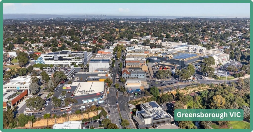
Greensborough doesn’t behave like a suburb still finding its shape. It’s spent more than forty years as the working commercial heart of Melbourne’s north-east (Greensy, the mall in the middle of it, has been the regional shopping fix for the area since 1978), and it isn’t chasing a rezoning to become relevant. What’s happening to it now is different: a fully built-out, largely owner-occupied suburb is being asked to intensify, not sprawl, while a tunnel gets bored under the highway on its doorstep. That combination, established bones plus active infrastructure investment, is rarer than either quality on its own.
Boundary Map
At 11.3km², Greensborough is bordered by St Helena to the north and Yallambie to the south, with the Plenty River forming a genuine natural boundary along both its eastern and southern edges, which is also why the river trail system runs the full length of the suburb. Watsonia sits immediately across the rail corridor to the south-east. The Greensborough Bypass and Greensborough Highway mark the northern and western edges respectively.
Quick Facts
| LGA | Banyule City Council |
| Median House Price | $1,035,000 (CoreLogic, 12 months to ~March 2026) |
| Median Unit Price | ~$700,000 (OpenAgent, May 2026) |
| Population | 21,070 (2021 Census) |
| Growth Rate | Houses +1.5% (12 months); population +2.5% over the 2011-2021 decade |
| Transport | Hurstbridge Line, Greensborough Station (rebuilt 2023); SmartBus 901 (airport), 902 (Doncaster Shoppingtown) |
| Major Roads / Distance to CBD | Greensborough Bypass to M80 Ring Road; ~17km / 22.93km rail to Melbourne CBD |
| Big Build / Growth Pipeline | Structure Plan review through 2027; North East Link tunnel extension finishing 2026 |
| Crime Rate (LGA) | Reported jointly as Banyule-Nillumbik; not among Victoria’s higher-crime LGAs |
| Nearest Major Hospital | Austin Hospital, Heidelberg, ~8km (public teaching hospital) |
| Childcare Availability | Adequate (~14 centres locally, Exceeding/Meeting NQS ratings) |
| Zoned School | Greensborough Primary (No. 2062); Greensborough Secondary College, no capacity concerns identified |
| Best For | Upgraders and established families wanting land size and transport certainty, not a still-developing growth-corridor lifestyle |
Our Verdict
If you want a suburb still working out what it wants to be, look at the growth corridor further out. Greensborough suits people who want land size, a proper commercial centre you don’t have to drive to, and a functioning train line rather than one promised. They also need to be able to live with a few more years of North East Link construction noise near the highway. Other than that, it’s a settled, already-built suburb, not a suburb still becoming one.
In my mind, it’s well suited to families and upgraders who want land, an established street, and a shopping and civic centre that already exists rather than one still under construction. Also, for downsizers who want to stay local but shrink the block, as unit prices here grew faster than houses over the past year (4.5% against 1.5%), which fits a suburb where plenty of people are doing exactly that. It’s a weaker fit for anyone wanting the still-forming, everything-is-new feel of a fringe growth corridor; Greensborough’s dwelling growth to 2041 is real but modest by Melbourne standards, driven by densification of an already-built suburb rather than paddocks becoming housing estates.
Weighed against its closest neighbours, the picture holds together. Eltham, a few minutes further out, trades Greensborough’s mega-mall convenience for a more bohemian, arts-community feel and a noticeably higher price point, you’re paying for character and the green wedge setting, not for infrastructure. Watsonia, one stop down the same Hurstbridge line, is cheaper and smaller, without a comparable commercial centre or the same weight of current construction investment. Greensborough sits in between: bigger and more built-up than Watsonia, more retail-anchored and less precious than Eltham, and currently the only one of the three with a rail tunnel being extended on its doorstep.
The Backstory: Heritage & Origins
The name comes from Edward Bernard Green, a former army officer running the Port Phillip-to-Sydney mail contract, who bought 643 acres here in 1841 and had a township surveyed overlooking the Plenty River. Before that it was known as Keelbundoora, after the local parish. By 1868 the settlement had an Anglican church, a school (1855), a store, a post office and a hotel, and about 200 people. It stayed a horticultural district, orchards, market gardens, later dairying, right up until suburban subdivision took over in the 1950s.
Two heritage items worth knowing if you’re property hunting here: the house at 3 St Helena Road (VHD listing 121140) is a locally significant, rare Federation-era example, sited prominently above the river. Saxam Homestead on Diamond Creek Road, a late-1880s farmhouse and one of the district’s oldest surviving homesteads, is the more interesting story precisely because it’s not protected: assessed and rated in a 1999 conservation study, then left out of Council’s 2011 Heritage Review entirely. If you’re looking at anything with genuine age in this pocket, don’t assume Heritage Overlay protection either way. Check VicPlan for the specific address.
The Big Build & Growth Story
This is not a “nothing planned” suburb, and it’s not on the transport-project wishlist either, work is actually underway. North East Link has extended the existing Hurstbridge line rail tunnel near Grimshaw Street to almost 500m, making it Victoria’s third-longest rail tunnel behind the City Loop and the new Metro Tunnel. That’s sitting inside a roughly 5km stretch of track and signalling upgrades between Macleod and Greensborough stations, with finishing works scheduled for early-to-mid 2026. A new Grimshaw Street interchange, linking to the M80 Ring Road and North East Link, is meant to pull around 19,000 vehicles a day off Greensborough Road once it’s done.
Some of this is already delivered, not just promised: the modernised Greensborough Station opened in 2023, the line to Montmorency was duplicated, a new timetable added services from May 2023, and a 100-space multi-deck commuter car park with a bus interchange opened by late 2024.
The bigger structural story is Council’s own review of the Greensborough Structure Plan, the “Greenbook,” which dates to 2006. That review, branded “Re-imagining Greensborough,” runs through 2025 to 2027, and Council has said explicitly it’s partly a response to how much the level crossing removal program and North East Link have already reshaped the area. There’s also documented developer interest in redeveloping the East Main Street precinct near the station, tied to a long-running push for a proper bus interchange upgrade. This isn’t a suburb waiting on a rezoning announcement to justify itself. It’s an established Principal Activity Centre (zoned as such since 2013) working out how to add density around infrastructure that’s largely already delivered, rather than promised.
Getting Around: Transport & Distances
Greensborough Station puts you on the Hurstbridge Line, 22.93km by rail from Southern Cross (about 17km by road to the CBD). Two SmartBus routes run through the station interchange: the 901 heads toward Melbourne Airport via South Morang, Epping and Broadmeadows, and the 902 is the more useful one for shopping and work trips, running via Eltham to Doncaster Shoppingtown, Nunawading and Glen Waverley. Route 385 connects Greensborough Plaza to Whittlesea and Mernda North, where you can change for La Trobe University, Bundoora RMIT and Northland Shopping Centre. A handful of local routes fill in the rest; check Transport Victoria’s journey planner directly for anything time-sensitive, frequencies on the smaller routes vary.
By road, the Greensborough Bypass connects straight onto the M80 Ring Road, Melbourne’s orbital freeway, which is the practical route to everywhere that isn’t a straight run down the Hurstbridge line.
Crime and Safety, Honestly
Victoria reports crime by council area rather than suburb, and Greensborough’s is now reported jointly with Nillumbik, a reporting change from 2024 that reflects how the two council boundaries actually meet here. Neither council features among Victoria’s higher-crime LGAs; the areas that consistently top the state’s incident-rate rankings are inner-city and regional centres like Melbourne, Yarra and Latrobe, not established middle-ring suburbs like this one. Statewide, recorded offences rose 2.4% over the year to December 2025, driven mostly by theft, including a jump in thefts from parked cars, worth bearing in mind if you’re street-parking rather than garaging.
Schools and Childcare
Greensborough Primary School (zoned, Prep-6) sits in the suburb proper; Greensborough Secondary College technically sits just over the boundary in Watsonia but is the local government secondary option, formed in 1990 from the merger of Watsonia High and Watsonia Technical School. St Mary’s on Grimshaw Street is the Catholic primary option. Roughly 14 long day care centres operate locally, including Milestones Early Learning (rated Exceeding NQS) and Wallaby Early Learning Centre (rated Meeting NQS). Unlike a growth-corridor suburb, there’s no visible gap between supply and demand here, population growth is slow enough that childcare and schooling capacity aren’t under the kind of strain you’d see further out on the fringe.
Hospitals and Healthcare
The nearest major public hospital is Austin Hospital in Heidelberg, about 8km away, a full public teaching hospital with an emergency department and Victoria-wide services including acute spinal injury care and liver transplant. Mercy Hospital for Women sits right next door for obstetric and neonatal care, including one of only four neonatal intensive care units in the state, relevant if you’re planning a family here. For everyday healthcare, Banyule Community Health (also trading as Holstep Health) runs a service on Grimshaw Street in Greensborough itself, and there’s a reasonable spread of private GP clinics locally rather than a single default option.
Parks, Attractions & Fitness
The Plenty River Trail system is the backbone of it. A roughly 2.5km loop near the centre, enter via Kalparrin Avenue, takes in Whatmough Park and Carter Reserve, crossing a suspension footbridge over fruit trees estimated at a century old. Push further and an 8km route takes in the Andrew Yandell Nature Reserve, habitat for the endangered Eltham Copper Butterfly, plus a children’s pioneer cemetery and the so-called Batman Apple Tree. The separate Greensborough Bypass Trail adds another 4.1km shared path along the highway corridor.
For organised sport and fitness, WaterMarc is the anchor, a council-built aquatic and leisure centre that also houses the civic offices, functioning as shared infrastructure rather than a token community room. The Diamond Valley Little Athletics Centre, based here, is the largest of its kind in the state, with more than 750 registered participants. Greensborough War Memorial Park is home to the Greensborough Football Club, founded in 1893 and still one of the more decorated clubs in the Northern Football Netball League.
Shopping and Dining
Greensborough Plaza, “Greensy” to anyone who’s lived here more than a year, has anchored the suburb since 1978 (it went through a brief spell as “Valley Central” around 1990 before reverting to its current name in 1995). It’s a serious operation: around 170-185 specialty stores across roughly 70,800m², anchored by Coles, Kmart, Target and Aldi, plus JB Hi-Fi, Chemist Warehouse, Rebel Sport, a Hoyts cinema and an Anytime Fitness, with about 2,700 car spaces, half of them undercover, some 950m from the train station. There’s an on-site dining and lifestyle precinct with a food court and a newer “On the Green” dining addition. If you want something less mall-shaped, Main Street is the older strip alternative, running into Diamond Creek Road, better for an independent cafe than a big weekly shop.
What It’s Actually Like to Live Here
Weekends here tend to gravitate toward one of two poles: the Plaza car park on a Saturday morning, which fills up fast, or the river trails, which don’t. Locals who’ve been here decades still call the mall “Greensy” without irony, and there’s an unselfconscious, lived-in quality to the place that comes from being a real regional centre rather than a suburb performing one for a real estate listing. The demographics back that up: a median age of 41 against the state’s 38, and over 80% owner-occupied, this is a suburb of people who’ve been here a while and plan to stay, not one cycling through renters every year or two. WaterMarc, drawing more than 800,000 visits in a recent year across a suburb of 21,000 people, tells the same story: this is infrastructure people actually use, not a token facility. It’s not a suburb built around a cafe strip or a single Instagram-able street; it’s built around infrastructure that works, which reads as unglamorous until you’re the one using it daily.
Trade-offs
The North East Link works near Grimshaw Street and Watsonia mean genuine construction disruption on the doorstep for a few more years yet, not everyone wants to live next to an active tunnel-extension project, however necessary the end result. The suburb’s median age (41, against Victoria’s 38) and modest decade-long population growth (2.5%) tell you this isn’t a suburb full of young families moving in en masse; it’s an established, ageing-in-place community, which suits some buyers and will feel slow to others. And heritage protection here is patchy rather than blanket: don’t assume an older-looking property is protected just because it looks the part.
FAQ
What are property prices like in Greensborough? The median house price is $1,035,000, up a modest 1.5% over the past year; units are cheaper and grew faster at 4.5%. Houses spend an average of 25 days on market.
Does Greensborough have a train station? Yes, on the Hurstbridge Line, rebuilt and reopened in 2023 with a new commuter car park and bus interchange added by 2024.
Is Greensborough safe? Crime is reported at the combined Banyule-Nillumbik council level rather than suburb by suburb, and neither council ranks among Victoria’s higher-crime areas; the state’s worst rates are concentrated in inner-city and regional centres, not established middle-ring suburbs like this one.
What are the best schools zoned for Greensborough? Greensborough Primary School (government) and Greensborough Secondary College (government, technically sited in neighbouring Watsonia) are the zoned local options, with St Mary’s as the Catholic primary alternative.
References
- Australian Bureau of Statistics. 2021 Census All Persons QuickStats, Greensborough (SAL21104).
- City of Banyule. Population and household forecasts, 2021-2041, prepared by .id (informed decisions), February 2023.
- City of Banyule. About the profile areas, Greensborough (boundary and locality description), profile.id.
- Crime Statistics Agency Victoria. Latest Victorian crime data, year ending March 2026, and recorded crime statistics, year ending December 2025.
- Heritage Council of Victoria. Victorian Heritage Database, House, 3 St Helena Road, Greensborough, Place ID 121140.
- Banyule City Council. Saxam Homestead heritage assessment, 108 Diamond Creek Road, Greensborough.
- Banyule City Council. Greensborough Structure Plan review, “Re-imagining Greensborough” project page, 2025-2027.
- Banyule City Council. Greensborough Principal Activity Centre advocacy fact sheet.
- Victoria’s Big Build, Department of Transport and Planning. Hurstbridge Line upgrade fact sheets; North East Link project pages.
- Victorian Department of Education and Training. Victorian State Schools Directory, Greensborough Primary School, School No. 2062.
- Australian Children’s Education and Care Quality Authority (ACECQA). National Registers, Wallaby Early Learning Centre Greensborough.
- Starting Blocks, Australian Government Department of Education. Find Child Care, Greensborough listings.
- Austin Health. Austin Hospital service information, Heidelberg.
- healthdirect Australia, Australian Government Department of Health and Aged Care. Service Finder, Greensborough listings.