
Melton East doesn’t exist yet, not in any sense a buyer can walk around in. As of this week it’s a signature on a planning document: Victorian Planning Minister Sonya Kilkenny approved the Melton East Precinct Structure Plan on 20 August 2026, rezoning 1,005 hectares of paddock immediately east of Melton township for close to 12,000 homes and more than 36,000 future residents. That makes this profile different from every other suburb in this series. There’s no crime rate to report, no school to rank, no shop to visit, only a government plan, a rezoning, and a very long runway before anyone moves in.
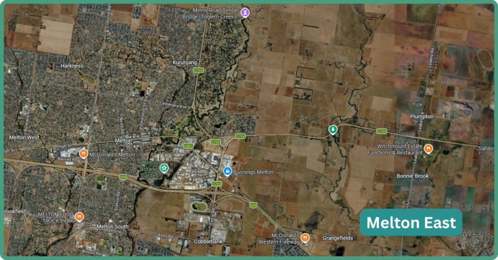
Melton East Boundary Map
Melton East sits in the City of Melton, bounded by Kororoit Creek to the north-east, the Western Freeway to the south, Leakes Road to the east and Melton Highway to the north-west, immediately east of the existing Melton township, roughly 35km north-west of the Melbourne CBD. The precinct absorbs the small, already-gazetted suburb of Grangefields (population 132 at the 2021 Census) along with the surrounding rural land around it.
Our Thoughts
Don’t consider here expecting anything resembling a suburb any time soon: Melton East is a rezoning, not a rollout, and the honest starting point for anyone reading this is that there’s no home to inspect, no street to drive down, and no confirmed date for when that changes. If you’re chasing the earliest possible entry into a masterplanned growth precinct and you’re comfortable holding through a 20-to-30-year build-out, this is a genuine first-mover opportunity. If you want livability within the next few years, or even the next decade with confidence, look at its established neighbors such as Melton, Melton South, Melton West, or the fast-developing suburbs of Strathtulloh, Deanside, Rockbank, Aintree or Thornhill Park instead, which already have residents, schools open and retail trading.
It does likely suit patient land-bank investors and developers tracking the Melton corridor’s next release wave, not owner-occupiers just yet. The one big thing Melton East will have in its favour is the massive development that’s been going on around it for decades.
Weighed against its immediate corridor neighbours, Strathtulloh and Deanside both cleared this exact “still building” phase within the last few years and now have primary schools running, if straining under enrolment growth, and at least one functioning shopping strip each. Melton East is roughly where those suburbs stood before their own PSPs were finalised: real numbers on paper (nearly 12,000 homes, seven schools, four community hubs, three arterial roads), zero of it built. Against the established Melton township it will eventually adjoin, the contrast is stark: Melton has its station, its Botanic Garden, its shopping strip and 140 years of settlement behind it. Melton East has a rezoning that’s a few days old.
The News: What Was Just Approved
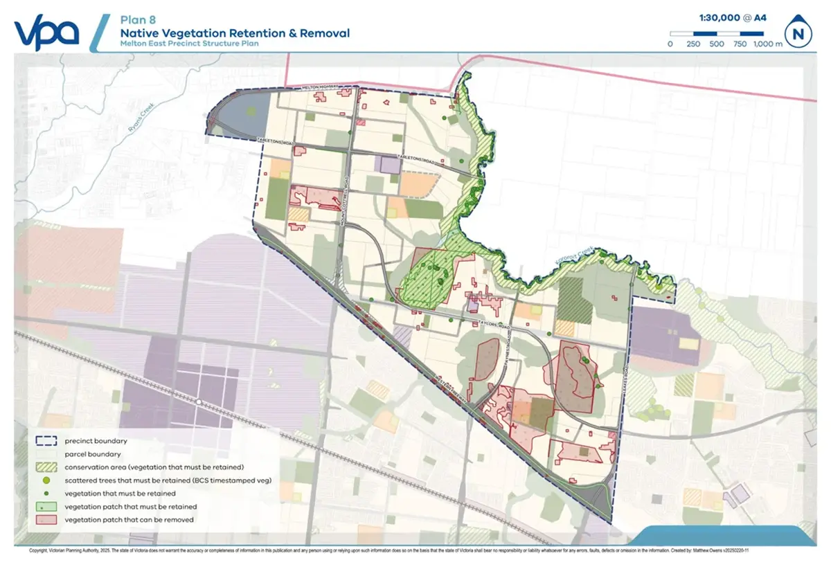
On 20 August 2026, the Victorian Government announced that Minister for Planning Sonya Kilkenny had approved the Melton East Precinct Structure Plan, the formal planning document that unlocks large-scale residential rezoning for the area. The mechanism is draft Melton Planning Scheme Amendment C244melt, which inserts a new Schedule 13 to the Urban Growth Zone (UGZ13) across the developable land, and applies Rural Conservation Zone 3 (RCZ3) to a conservation buffer along Kororoit Creek, intended to protect Growling Grass Frog habitat under the federal Melbourne Strategic Assessment Biodiversity Conservation Strategy. The amendment also layers in an Environmental Audit Overlay, a Heritage Overlay protecting the Beattys Road Nissen Hut, a Public Acquisition Overlay reserving land for a future Mount Cotrell Road/Western Freeway interchange, and an Infrastructure Contributions Overlay to fund the roads, schools and open space that come with the plan.
Minister Kilkenny framed the approval plainly: “We’re unlocking space to deliver thousands of more homes, as we deliver the infrastructure these communities need.” Local members Steve McGhie (Melton) and Luba Grigorovitch (Kororoit) were also quoted welcoming the plan. Genuinely worth flagging honestly rather than glossing over: the planning scheme amendment itself has NOT yet been formally gazetted as of this profile’s writing, the government’s own timeline says gazettal is expected “in the coming weeks” from the 20 August announcement, so treat this as approved-in-principle and imminent, not yet legally in force.
It’s also worth being precise about what “new suburb” actually means here. Media coverage has broadly reported this as a brand-new suburb, but no official record could be found confirming “Melton East” has been, or will be, formally gazetted as a distinct suburb locality name by Victoria’s Office of Geographic Names. The 1,005-hectare precinct physically absorbs the existing, already-gazetted suburb of Grangefields (created in 2017, population 132), plus surrounding rural land. “Melton East” is, on current evidence, the state’s planning-project name for the precinct, not a confirmed new suburb name, an important distinction for anyone searching property listings under that exact name expecting an established locality to already exist.
What’s Actually Planned
The approved figures, per the government’s own release, are nearly 12,000 homes and more than 36,000 residents at full build-out, supporting around 1,600 local jobs, across seven schools (four government primary, one government secondary, and land reserved for two non-government primary schools, no names or opening years announced for any of them).

Community infrastructure runs to four multipurpose community hubs with kindergartens, two neighbourhood activity centres plus two local convenience centres for retail, a regional active open space facility, three further active open space facilities, and 14 local parks, described by the government as “more than five MCGs’ worth” of green space.
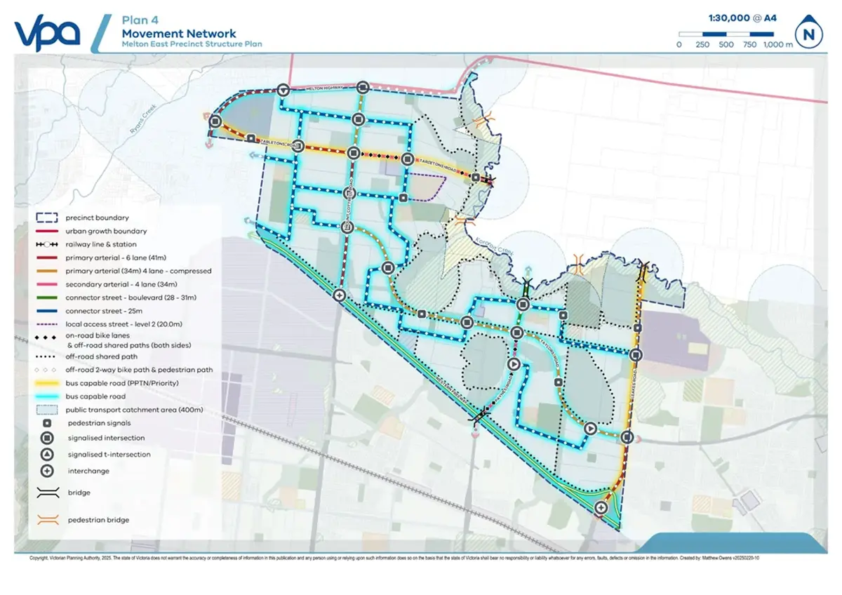
Road infrastructure includes three new arterial roads, 14 intersections and five bridges, with two of those bridge crossings over Kororoit Creek specifically located at Tarletons Road and Paynes Road, where cultural heritage excavation permits have already been granted.
Timeline and What Happens Next
Full build-out is expected to take 20 to 30 years, consistent across every source covering the announcement. No date has been published anywhere for the first land release, first land sales, or first residents moving in. The PSP approval clears the way for developers to begin lodging permit applications, a necessary step before subdivision can start, but it isn’t itself a construction start date, and no developer has yet been publicly named as attached to the project. Anyone considering this precinct as an investment should treat “when can I actually buy a block” as a genuinely open question right now, not a settled one.
The approval followed a multi-year process: technical and environmental studies, agency validation in March 2024, a public consultation period from 3 to 31 March 2025 that drew 41 submissions (some reportedly concerning school site placement and housing density, though the full detail of those objections wasn’t independently verifiable in this research), referral to the VPA Projects Standing Advisory Committee in April 2025, and ministerial approval in August 2026.
The Conservation Angle
The Rural Conservation Zone 3 buffer along Kororoit Creek is a genuinely distinctive feature of this plan compared to some earlier Melton-corridor precincts covered in this series: it’s an explicit habitat protection measure for the Growling Grass Frog, tied to a federal biodiversity strategy rather than a generic green-space commitment. Combined with the “five MCGs” of planned parks and reserves, it suggests Melton East’s eventual open-space provision may be more deliberately planned than some of its predecessors, though none of it exists on the ground yet and none of the specific park or reserve locations have been detailed publicly.
Trade-offs
The single biggest trade-off is time: this is a 20-to-30-year build-out with no confirmed date for the first home, let alone a functioning suburb. No train station is currently committed, a real and stated gap rather than an unfunded promise like some neighbouring suburbs at least have. No developer has been named, no school names or opening dates exist, and the precinct’s own naming status is genuinely unclear, “Melton East” functions as a government planning name layered over the existing suburb of Grangefields and surrounding rural land, not a confirmed new suburb locality. Early draft population and jobs figures that don’t match the final announcement point to a plan still being refined even after ministerial approval. Set against all of that, the genuine upside is real: a rare chance to track a large, government-committed growth precinct from its very first approved document, for buyers with the patience and risk tolerance for exactly that.
FAQ
Is Melton East a real suburb yet? Not in the fully official sense. The Victorian Government approved its Precinct Structure Plan on 20 August 2026 and describes it as a new suburb in its own messaging, but no record confirms formal gazettal of “Melton East” as a distinct suburb locality name, and the underlying planning scheme amendment itself is still awaiting formal gazettal, expected “in the coming weeks” from the announcement.
How many homes and people is Melton East planned for? Nearly 12,000 homes and more than 36,000 residents at full build-out, per the government’s 20 August 2026 announcement, supporting around 1,600 local jobs. Earlier draft planning documents cited higher figures (14,000 homes, 43,000 residents), a discrepancy not officially reconciled.
Does Melton East have a train station? No commitment has been made for a station within the precinct itself. The nearest confirmed rail investment nearby is electrification of the existing Melton line serving Melton township.
When can I buy land in Melton East? No date has been published. The PSP approval allows developers to begin lodging permit applications, a precondition for subdivision, but no land release date, developer name, or first-resident timeline currently exists.
References
- Premier of Victoria. Media release, “New Suburb In Melbourne’s Booming West.” 20 August 2026.
- Victorian Planning Authority. Melton East project page, vpa.vic.gov.au. Accessed 22 August 2026.
- Victorian Planning Authority. FAQ, “Why is the Melton Planning Scheme being amended for this PSP?” Accessed 22 August 2026.
- Planning Panels Victoria. VPA Projects referral 12: Melton East Precinct Structure Plan and Infrastructure Contributions Plan.